FAA INFORMATION EFFECTIVE 09 JULY 2026
Location
| FAA Identifier: | HTL |
| Lat/Long: | 44-21-35.5285N 084-40-10.1389W
44-21.592142N 084-40.168982W
44.3598690,-84.6694830
(estimated) |
| Elevation: | 1149.7 ft. / 350.4 m (surveyed) |
| Variation: | 05W (1985) |
| From city: | 5 miles NE of HOUGHTON LAKE, MI |
| Time zone: | UTC -4 (UTC -5 during Standard Time) |
| Zip code: | 48629 |
Airport Operations
| Airport use: | Open to the public |
| Activation date: | 08/1945 |
| Control tower: | no |
| ARTCC: | MINNEAPOLIS CENTER |
| FSS: | LANSING FLIGHT SERVICE STATION |
| NOTAMs facility: | HTL (NOTAM-D service available) |
| Attendance: | 0900-1700
UNATNDD MAJOR HOLS. |
| Wind indicator: | lighted |
| Segmented circle: | yes |
| Lights: | ACTVT OR INCR INTST REIL RWY 09 & 27; PAPI RWY 09 & 27; HIRL RWY 09/27 - CTAF. HIRL RWY 09/27 PRESET LOW INTST DUSK-2100. |
| Beacon: | white-green (lighted land airport)
Operates sunset to sunrise. |
Airport Communications
| CTAF/UNICOM: | 122.8 |
| WX ASOS: | 118.05 (989-200-3352) |
| WX ASOS at GOV (19 nm N): | PHONE 989-348-3127 |
- APCH/DEP SVC PRVDD BY MINNEAPOLIS ARTCC ON 125.475/269.45 (ALPENA RCAG).
Nearby radio navigation aids
| VOR radial/distance | | VOR name | | Freq | | Var |
|---|
| CGGr179/(19.5) | | GRAYLING VOR | | 109.80 | | 06W |
| NDB name | | Hdg/Dist | | Freq | | Var | | ID |
|---|
| GRAYLING | | 170/24.4 | | 359 | | 06W | | GYG | --. -.-- --. |
Airport Services
| Fuel available: | 100LL |
| Parking: | tiedowns |
| Airframe service: | MAJOR |
| Powerplant service: | MAJOR |
| Bottled oxygen: | NONE |
| Bulk oxygen: | NONE |
Runway Information
Runway 9/27
| Dimensions: | 4000 x 75 ft. / 1219 x 23 m |
| Surface: | asphalt, in good condition |
| Weight bearing capacity: | |
| Runway edge lights: | high intensity |
| RUNWAY 9 | | RUNWAY 27 |
| Latitude: | 44-21.674222N | | 44-21.687320N |
| Longitude: | 084-40.437315W | | 084-39.519938W |
| Elevation: | 1147.8 ft. | | 1144.7 ft. |
| Traffic pattern: | left | | left |
| Runway heading: | 094 magnetic, 089 true | | 274 magnetic, 269 true |
| Markings: | nonprecision, in fair condition | | nonprecision, in fair condition |
| Visual slope indicator: | 4-light PAPI on left (3.50 degrees glide path) | | 4-light PAPI on right (3.50 degrees glide path) |
| Runway end identifier lights: | yes | | yes |
| Touchdown point: | yes, no lights | | yes, no lights |
Runway 18/36
| Dimensions: | 2200 x 100 ft. / 671 x 30 m |
| Surface: | turf, in good condition |
| Runway edge markings: | 3 FT YELLOW CONES. |
| Operational restrictions: | CLSD WHEN SNOW COVD EXC FOR SKI EQUIPPED ACFT. |
| RUNWAY 18 | | RUNWAY 36 |
| Latitude: | 44-21.612000N | | 44-21.250000N |
| Longitude: | 084-40.524667W | | 084-40.505500W |
| Elevation: | 1148.3 ft. | | 1144.3 ft. |
| Traffic pattern: | left | | left |
| Runway heading: | 183 magnetic, 178 true | | 003 magnetic, 358 true |
| Displaced threshold: | no | | 200 ft. |
| Touchdown point: | yes, no lights | | yes, no lights |
| Obstructions: | 107 ft. tree, 1815 ft. from runway, 324 ft. left of centerline, 16:1 slope to clear | | 6 ft. brush, 20 ft. from runway, 88 ft. right of centerline, 3:1 slope to clear
CTLG OBSTN EXCEEDS A 45 DEG SLP. APCH RATIO 3:1 TO DTHR OVR +6 FT BRUSH, 20 FT DIST, 88 FT R. |
Airport Ownership and Management from official FAA records
| Ownership: | Publicly-owned |
| Owner: | ROSCOMMON COUNTY
500 LAKE ST
ROSCOMMON, MI 48653-7664
Phone 989-275-8021 |
| Manager: | ERIC J JAROCH
5220 E HOUGHTON LAKE DR
HOUGHTON LAKE, MI 48629-8313
Phone 989-366-7660
CELL 989-390-2398. |
Additional Remarks
| - | DEER, BIRDS, & WILDLIFE ON & INVOF ARPT. |
| - | 2203 FT MSL (883 AGL) TOWER 4.2 NM SW OF ARPT. |
| - | FOR CD CTC MINNEAPOLIS ARTCC AT 651-463-5588. |
Instrument Procedures
NOTE: All procedures below are presented as PDF files. If you need a reader for these files, you should download the free Adobe Reader.NOT FOR NAVIGATION. Please procure official charts for flight.
FAA instrument procedures published for use from 09 July 2026 at 0901Z to 06 August 2026 at 0900Z.
IAPs - Instrument Approach Procedures |
|---|
| RNAV (GPS) RWY 09 | |
download (206KB) |
| RNAV (GPS) RWY 27 | |
download (208KB) |
| NOTE: Special Alternate Minimums apply | |
download (138KB) |
| NOTE: Special Take-Off Minimums/Departure Procedures apply | |
download (358KB) |
Other nearby airports with instrument procedures:
KGOV - Grayling Army Airfield (19 nm N)
Y31 - West Branch Community Airport (22 nm E)
KGDW - Gladwin Zettel Memorial Airport (25 nm S)
48D - Clare Municipal Airport (32 nm S)
KCAD - Wexford County Airport (33 nm W)
|
|

Road maps at:
MapQuest
Bing
Google
| Aerial photo |
|---|
WARNING: Photo may not be current or correct
 Photo by Bev Smith, with Brad Smith piloting
Taken in June 2008
from their Cessna 172 at 1000 feet AGL
Photo by Bev Smith, with Brad Smith piloting
Taken in June 2008
from their Cessna 172 at 1000 feet AGL
Do you have a better or more recent aerial photo of Roscommon County/Blodgett Memorial Airport that you would like to share? If so, please send us your photo.
|
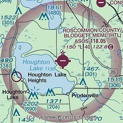
| Sectional chart |
|---|
|
| Airport distance calculator |
|---|
|
|
| Sunrise and sunset |
|---|
|
Times for 26-Jul-2026
| | Local
(UTC-4) | | Zulu
(UTC) |
|---|
| Morning civil twilight | | 05:46 | | 09:46 |
| Sunrise | | 06:20 | | 10:20 |
| Sunset | | 21:10 | | 01:10 |
| Evening civil twilight | | 21:44 | | 01:44 |
|
| Current date and time |
|---|
| Zulu (UTC) | 26-Jul-2026 05:11:56 |
|---|
| Local (UTC-4) | 26-Jul-2026 01:11:56 |
|---|
|
| METAR |
|---|
| KHTL | 260453Z AUTO 21004KT 10SM OVC050 21/15 A2993 RMK AO2 SLP132 T02110150 402610083
|
|
| NOTAMs |
|---|
NOTAMs are issued by the DoD/FAA and will open in a separate window not controlled by AirNav.
|
|

