FAA INFORMATION EFFECTIVE 11 JUNE 2026
Location
| FAA Identifier: | IYA |
| Lat/Long: | 29-58-32.8000N 092-05-03.2000W
29-58.546667N 092-05.053333W
29.9757778,-92.0842222
(estimated) |
| Elevation: | 15.9 ft. / 4.8 m (surveyed) |
| Variation: | 02E (2005) |
| From city: | 3 miles E of ABBEVILLE, LA |
| Time zone: | UTC -5 (UTC -6 during Standard Time) |
| Zip code: | 70510 |
Airport Operations
| Airport use: | Open to the public |
| Activation date: | 04/1948 |
| Control tower: | no |
| ARTCC: | HOUSTON CENTER |
| FSS: | DE RIDDER FLIGHT SERVICE STATION |
| NOTAMs facility: | DRI (NOTAM-D service available) |
| Attendance: | DAYLIGHT HOURS |
| Pattern altitude: | 351.9 ft. MSL
TPA 336 FT AGL ULTRLIGHT WI 3 MILES OF ARPT. |
| Wind indicator: | lighted |
| Segmented circle: | no |
| Lights: | DUSK-DAWN. MIRL RY 16/34 & REIL RYS 16 & 34 PRESET LOW INTST DUSK-DAWN; TO INCR INTST ACTVT - CTAF. |
| Beacon: | white-green (lighted land airport)
Operates sunset to sunrise. |
Airport Communications
| CTAF/UNICOM: | 122.8 |
| WX AWOS-3PT: | 118.875 (337-892-0526) |
| LAFAYETTE APPROACH: | 121.1 |
| LAFAYETTE DEPARTURE: | 121.1 |
| WX ASOS at ARA (11 nm E): | 133.325 (337-492-4830) |
| WX ASOS at LFT (15 nm N): | 134.05 (337-262-2757) |
- APCH/DEP SVC PRVDD BY HOUSTON ARTCC (ZHU) ON FREQS 126.35/338.25 (LAFAYETTE RCAG) WHEN LAFAYETTE (LFT) APCH CTL CLSD.
Nearby radio navigation aids
| VOR radial/distance | | VOR name | | Freq | | Var |
|---|
| LFTr197/13.9 | | LAFAYETTE VORTAC | | 109.80 | | 03E |
| LLAr035/24.1 | | WHITE LAKE VOR/DME | | 114.95 | | 04E |
| NDB name | | Hdg/Dist | | Freq | | Var | | ID |
|---|
| ABBEVILLE | | 156/5.5 | | 230 | | 02E | | BNZ | -... -. --.. |
Airport Services
| Fuel available: | 100LL JET-A |
| Parking: | hangars and tiedowns |
| Airframe service: | MAJOR |
| Powerplant service: | MAJOR |
| Bottled oxygen: | NONE |
| Bulk oxygen: | NONE |
Runway Information
Runway 16/34
| Dimensions: | 5000 x 75 ft. / 1524 x 23 m |
| Surface: | asphalt, in excellent condition |
| Weight bearing capacity: | |
| Runway edge lights: | medium intensity |
| RUNWAY 16 | | RUNWAY 34 |
| Latitude: | 29-58.930353N | | 29-58.162202N |
| Longitude: | 092-05.226245W | | 092-04.880993W |
| Elevation: | 15.7 ft. | | 14.5 ft. |
| Traffic pattern: | left | | left |
| Runway heading: | 157 magnetic, 159 true | | 337 magnetic, 339 true |
| Markings: | nonprecision, in good condition | | nonprecision, in good condition |
| Visual slope indicator: | 2-light PAPI on left (3.00 degrees glide path) | | 2-light PAPI on left (3.00 degrees glide path) |
| Runway end identifier lights: | yes | | yes |
| Touchdown point: | yes, no lights | | yes, no lights |
| Instrument approach: | LOCALIZER | | |
| Obstructions: | 7 ft. fence, 360 ft. from runway, 22:1 slope to clear | | 47 ft. trees, 1315 ft. from runway, 183 ft. left of centerline, 23:1 slope to clear |
Helipad H1
| Dimensions: | 80 x 80 ft. / 24 x 24 m |
| Surface: | concrete |
| Latitude: | 29-58.462000N | | |
| Longitude: | 092-05.185333W | | |
| Elevation: | 14.0 ft. | | |
| Traffic pattern: | left | | left |
Airport Ownership and Management from official FAA records
| Ownership: | Publicly-owned |
| Owner: | CITY OF ABBEVILLE
BOX 1170
ABBEVILLE, LA 70510
Phone 337-898-4206 |
| Manager: | MAYOR ROSLYN WHITE
BOX 1170
ABBEVILLE, LA 70510
Phone (337) 898-4206 |
Additional Remarks
| - | GCO AVBL ON FREQ 135.075 THRU LAFAYETTE APCH & DE RIDDER FSS. |
| - | FOR CD CTC LAFAYETTE APCH AT 337-262-2729, WHEN APCH CLSD CTC HOUSTON ARTCC AT 281-230-5622. |
| - | CTC ARPT MGR FOR DSNGD RAMP SPACE FOR PUB USE AT ARPT |
Instrument Procedures
NOTE: All procedures below are presented as PDF files. If you need a reader for these files, you should download the free Adobe Reader.NOT FOR NAVIGATION. Please procure official charts for flight.
FAA instrument procedures published for use from 11 June 2026 at 0901Z to 09 July 2026 at 0900z.
IAPs - Instrument Approach Procedures |
|---|
| RNAV (GPS) RWY 16 | |
download (202KB) |
| RNAV (GPS) RWY 34 | |
download (218KB) |
| LOC RWY 16 | |
download (219KB) |
| NOTE: Special Alternate Minimums apply | |
download (181KB) |
| NOTE: Special Take-Off Minimums/Departure Procedures apply | |
download (303KB) |
Other nearby airports with instrument procedures:
KARA - Acadiana Regional Airport (11 nm E)
KLFT - Lafayette Regional Airport/Paul Fournet Field (15 nm N)
4R7 - Eunice Airport (34 nm NW)
3R7 - Jennings Airport (35 nm NW)
KOPL - St Landry Parish Airport (35 nm N)
|
|

Road maps at:
MapQuest
Bing
Google
| Aerial photo |
|---|
WARNING: Photo may not be current or correct
 Photo by Chris Fontana, Lafayette, LA
Photo taken 30-Dec-2016
looking north.
Photo by Chris Fontana, Lafayette, LA
Photo taken 30-Dec-2016
looking north.
Do you have a better or more recent aerial photo of Abbeville Chris Crusta Memorial Airport that you would like to share? If so, please send us your photo.
|
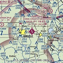
| Sectional chart |
|---|
|
| Airport distance calculator |
|---|
|
|
| Sunrise and sunset |
|---|
|
Times for 12-Jun-2026
| | Local
(UTC-5) | | Zulu
(UTC) |
|---|
| Morning civil twilight | | 05:40 | | 10:40 |
| Sunrise | | 06:08 | | 11:08 |
| Sunset | | 20:09 | | 01:09 |
| Evening civil twilight | | 20:36 | | 01:36 |
|
| Current date and time |
|---|
| Zulu (UTC) | 12-Jun-2026 06:04:18 |
|---|
| Local (UTC-5) | 12-Jun-2026 01:04:18 |
|---|
|
| METAR |
|---|
| KIYA | 120555Z AUTO 00000KT 10SM FEW020 26/26 A2997 RMK AO2 T02590259 10299 20258 403210225 51012 $
|
| K0R3 | 118.875
No observation available
|
KARA
11nm E | 120553Z AUTO 12004KT 10SM FEW022 26/24 A2999 RMK AO2 SLP154 T02560239 10300 20250 403220233 51012
|
KLFT
14nm N | 120553Z AUTO 00000KT 10SM CLR 26/24 A2999 RMK AO2 SLP155 T02560244 10300 20256 403280233 51013
|
|
| TAF |
|---|
KARA
11nm E | 120541Z 1206/1306 18006KT P6SM SCT030
|
KLFT
14nm N | 111720Z 1118/1218 18007KT P6SM SCT030 FM120300 VRB03KT P6SM SCT250
|
|
| NOTAMs |
|---|
NOTAMs are issued by the DoD/FAA and will open in a separate window not controlled by AirNav.
|
|


