FAA INFORMATION EFFECTIVE 09 JULY 2026
Location
| FAA Identifier: | LKU |
| Lat/Long: | 38-00-35.3690N 077-58-12.4560W
38-00.589483N 077-58.207600W
38.0098247,-77.9701267
(estimated) |
| Elevation: | 493.7 ft. / 150.5 m (surveyed) |
| Variation: | 10W (2010) |
| From city: | 2 miles SE of LOUISA, VA |
| Time zone: | UTC -4 (UTC -5 during Standard Time) |
| Zip code: | 23093 |
Airport Operations
| Airport use: | Open to the public |
| Activation date: | 06/1987 |
| Control tower: | no |
| ARTCC: | WASHINGTON CENTER |
| FSS: | LEESBURG FLIGHT SERVICE STATION |
| NOTAMs facility: | LKU (NOTAM-D service available) |
| Attendance: | MON-SAT 0830-1700, ALL SUN 1000-1700 |
| Wind indicator: | lighted |
| Segmented circle: | yes |
| Lights: | ACTVT REIL RWY 09/27; PAPI RWY 09 & 27; MIRL RWY 09/27 - CTAF. |
| Beacon: | white-green (lighted land airport)
Operates sunset to sunrise. |
Airport Communications
| CTAF/UNICOM: | 122.975 |
| WX AWOS-3: | 119.475 (540-967-1983) |
| POTOMAC APPROACH: | 132.85 120.525 |
| POTOMAC DEPARTURE: | 132.85 120.525 |
| WX AWOS-3 at 7W4 (11 nm E): | 120.775 (540-872-0303) |
| WX AWOS-3 at GVE (13 nm NW): | 120.225 (540-832-2095) |
| WX AWOS-3 at OMH (15 nm N): | 118.075 (540-672-0505) |
Nearby radio navigation aids
| VOR radial/distance | | VOR name | | Freq | | Var |
|---|
| GVEr098/8.6 | | GORDONSVILLE VORTAC | | 115.60 | | 06W |
| FAKr353/29.7 | | FLAT ROCK VORTAC | | 113.30 | | 06W |
| BRVr245/35.1 | | BROOKE VORTAC | | 114.50 | | 09W |
| CSNr193/38.2 | | CASANOVA VORTAC | | 116.30 | | 06W |
| NDB name | | Hdg/Dist | | Freq | | Var | | ID |
|---|
| NAILR | | 197/26.8 | | 351 | | 10W | | MSQ | -- ... --.- |
| SHANNON | | 248/29.0 | | 237 | | 10W | | EZF | . --.. ..-. |
Airport Services
| Fuel available: | 100LL JET-A |
| Parking: | hangars and tiedowns |
| Airframe service: | MAJOR |
| Powerplant service: | MAJOR |
Runway Information
Runway 9/27
| Dimensions: | 4300 x 100 ft. / 1311 x 30 m |
| Surface: | asphalt, in good condition |
| Weight bearing capacity: | |
| Runway edge lights: | medium intensity |
| RUNWAY 9 | | RUNWAY 27 |
| Latitude: | 38-00.542198N | | 38-00.636730N |
| Longitude: | 077-58.651320W | | 077-57.763887W |
| Elevation: | 469.4 ft. | | 493.5 ft. |
| Traffic pattern: | right | | left |
| Runway heading: | 092 magnetic, 082 true | | 272 magnetic, 262 true |
| Markings: | nonprecision, in good condition | | nonprecision, in good condition |
| Visual slope indicator: | 2-light PAPI on left (3.00 degrees glide path) | | 2-light PAPI on left (3.00 degrees glide path) |
| Runway end identifier lights: | yes | | yes |
| Touchdown point: | yes, no lights | | yes, no lights |
| Instrument approach: | | | LOC/DME |
| Obstructions: | 50 ft. trees, 1147 ft. from runway, 344 ft. right of centerline, 18:1 slope to clear | | none |
Airport Ownership and Management from official FAA records
| Ownership: | Publicly-owned |
| Owner: | COUNTY OF LOUISA
1 WOOLFOLK AVENUE, SUITE 301
LOUISA, VA 23093
Phone 540-967-0401 |
| Manager: | BRITTANY SHUPE
335 INDUSTRIAL DR, P.O. BOX 27
LOUISA, VA 23093
Phone 540-967-0050
BSHUPE@LOUISACOUNTY.GOV |
Additional Remarks
| - | BCN LOCATED ON WATER TWR; NORTH SIDE APCH RY 27. |
| - | DEER & BIRDS ON & INVOF ARPT. |
| - | 3 FT PVC GAS LINE MARKER LCTD APRX 26 FT FM RY 09 THLD, 54 FT LEFT OF CNTRLN. |
| - | FOR CD CTC POTOMAC APCH AT 540-349-9697 |
Instrument Procedures
NOTE: All procedures below are presented as PDF files. If you need a reader for these files, you should download the free Adobe Reader.NOT FOR NAVIGATION. Please procure official charts for flight.
FAA instrument procedures published for use from 09 July 2026 at 0901Z to 06 August 2026 at 0900Z.
IAPs - Instrument Approach Procedures |
|---|
| RNAV (GPS) RWY 09 | |
download (234KB) |
| RNAV (GPS) RWY 27 | |
download (227KB) |
| LOC RWY 27 | |
download (196KB) |
| NOTE: Special Alternate Minimums apply | |
download (143KB) |
| NOTE: Special Take-Off Minimums/Departure Procedures apply | |
download (357KB) |
Other nearby airports with instrument procedures:
7W4 - Lake Anna Airport (11 nm E)
KGVE - Gordonsville Municipal Airport (13 nm NW)
KOMH - Orange County Airport (15 nm N)
KCHO - Charlottesville-Albemarle Airport (24 nm W)
KEZF - Shannon Airport (29 nm NE)
|
|

Road maps at:
MapQuest
Bing
Google
| Aerial photo |
|---|
WARNING: Photo may not be current or correct

Do you have a better or more recent aerial photo of Louisa County Airport/Freeman Field that you would like to share? If so, please send us your photo.
|
| Sectional chart |
|---|
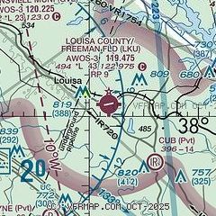
|
| Airport distance calculator |
|---|
|
|
| Sunrise and sunset |
|---|
|
Times for 21-Jul-2026
| | Local
(UTC-4) | | Zulu
(UTC) |
|---|
| Morning civil twilight | | 05:37 | | 09:37 |
| Sunrise | | 06:07 | | 10:07 |
| Sunset | | 20:30 | | 00:30 |
| Evening civil twilight | | 21:00 | | 01:00 |
|
| Current date and time |
|---|
| Zulu (UTC) | 21-Jul-2026 12:24:12 |
|---|
| Local (UTC-4) | 21-Jul-2026 08:24:12 |
|---|
|
| METAR |
|---|
| KLKU | 211155Z AUTO 20006KT 10SM SCT009 SCT100 SCT120 23/22 A2987 RMK AO2 T02310215 10236 20225
|
K7W4
11nm E | 211155Z AUTO 20006KT 10SM OVC010 23/22 A2986 RMK AO1 T02320220 10234 20225
|
KOMH
15nm N | 211155Z AUTO 20009KT 10SM CLR 22/21 A2985 RMK AO2
|
|
| TAF |
|---|
KCHO
24nm W | 211128Z 2112/2212 18007KT P6SM OVC004 FM211400 20007KT P6SM SCT025 BKN100 FM211700 22012G22KT P6SM SCT035 BKN100 TEMPO 2119/2122 1SM +TSRA OVC035CB FM220000 22011G18KT 5SM -TSRA OVC050CB FM220300 21009KT 6SM -SHRA OVC050 FM220700 21007KT P6SM BKN018
|
|
| NOTAMs |
|---|
NOTAMs are issued by the DoD/FAA and will open in a separate window not controlled by AirNav.
|
|

