FAA INFORMATION EFFECTIVE 14 MAY 2026
Location
| FAA Identifier: | LSF |
| Lat/Long: | 32-19-54.4100N 084-59-13.7480W
32-19.906833N 084-59.229133W
32.3317806,-84.9871522
(estimated) |
| Elevation: | 227 ft. / 69.2 m (surveyed) |
| Variation: | 05W (2025) |
| From city: | 5 miles SW of FORT BENNING (COLUMBUS), GA |
| Time zone: | UTC -4 (UTC -5 during Standard Time) |
| Zip code: | 31905 |
Airport Operations
| Airport use: | Private use. Permission required prior to landing |
| Control tower: | yes |
| ARTCC: | ATLANTA CENTER |
| FSS: | MACON FLIGHT SERVICE STATION |
| NOTAMs facility: | LSF (NOTAM-D service available) |
| Attendance: | CONTINUOUS |
| Pattern altitude: | TPA: FIXED WING ACFT 1800 FT, 360 DEG OVHD 2300 FT, ROTARY WING 1000 FT. |
| Segmented circle: | no |
| Lights: | ACTVT PAPI RWY 15 & 33; HIRL RWY 15/33 - CTAF. SALSF ON DRG TWR OPN. |
| Beacon: | white-white-green (lighted military airport)
Operates sunset to sunrise. |
Airport Communications
| CTAF: | 119.05 |
| ATIS: | 134.375 |
| LAWSON GROUND: | 121.7 254.25 [1230++MON-0400Z++ SAT, EXC HOLIDAYS.] |
| LAWSON TOWER: | 119.05 269.525 [1230++MON-0400Z++ SAT, EXC HOLIDAYS.] |
| ATLANTA APPROACH: | 125.5 126.55 ;7000 FT & ABV |
| ATLANTA DEPARTURE: | 125.5 126.55 ;7000 FT & ABV |
| CLEARANCE DELIVERY: | 121.7 251.15 |
| ADZY: | 126.2 ;BENNING ADVISORY 227.4 ;BENNING ADVISORY |
| ALCP: | 141.8 340.8 |
| AR OPS: | 372.2 |
| BASE OPS: | 134.1 245.7 247.4 343.2 372.2 |
| EMERG: | 121.5 243.0 |
| HEL OPS: | 41.5FM |
| PAR/P: | 132.4 226.6 |
| PAR/S: | 133.525 237.2 |
| PMSV METRO: | 343.2 |
| WX ASOS at CSG (11 nm N): | PHONE 706-748-8097 |
- ALCP OPER DURG SKED MSN.
- CTC AAS ON TWR FREQ PRIOR TO LNDG.
- APCH CTL WILL NOT PROVIDE RADAR SVC TO ACFT IN LSF CLASS D AIRSPACE 2700 FT & BLO WITHIN 4.2 NM RADIUS OF LSF ATCT.
- APCH/DEP SVC PRVDD BY ATLANTA LARGE TRACON 0615-2300 ON FREQS 125.5/323.1 BLW 7000 AND 126.55/353.75 7000 AND ABV. ATLANTA ARTCC PROVIDES APCH/DEP SVC 2300-0615 ON FREQS 120.45/298.850 (COLUMBUS RCAG).
- FULL SVC 1200Z++ MON-0100Z++ SAT, EXC HOL. LTD SVC OT. WX OBSN VIS LTD IN EFF AT FLD; IN NM ARE NE 3-16, E 1-4, SE 1-2, SW 1 1-2, NW-4, N 3-16. REMOTE WX BRIEFING SVC AVBL 26 OWS, BARKSDALE AFB, DSN 781-4775, C318-456-4775, FAX DSN 781-3493. BACKUP PTD 134.1.
Nearby radio navigation aids
| VOR radial/distance | | VOR name | | Freq | | Var |
|---|
| LSF at field | | LAWSON VOR/DME | | 111.40 | | 05W |
| EUFr016/24.0 | | EUFAULA VOR/DME | | 109.20 | | 02E |
| NDB name | | Hdg/Dist | | Freq | | Var | | ID |
|---|
| FENIX | | 161/7.7 | | 355 | | 02W | | CS | -.-. ... |
Airport Services
| Fuel available: | A JET-A++ |
| Bulk oxygen: | LOX SVC NOT AVBL. |
Runway Information
Runway 15/33
| Dimensions: | 10002 x 150 ft. / 3049 x 46 m |
| Surface: | asphalt |
| Weight bearing capacity: | |
| Runway edge lights: | high intensity |
| RUNWAY 15 | | RUNWAY 33 |
| Latitude: | 32-20.579940N | | 32-19.233742N |
| Longitude: | 084-59.790365W | | 084-58.667840W |
| Elevation: | 226.9 ft. | | 226.2 ft. |
| Traffic pattern: | right | | left |
| Displaced threshold: | no | | 700 ft. |
| Declared distances: | TORA:10002 TODA:10002 ASDA:10002 LDA:10002 | | TORA:10002 TODA:10002 ASDA:10002 LDA:9302 |
| Visual slope indicator: | 4-light PAPI on left (3.00 degrees glide path) | | 4-light PAPI on left (3.00 degrees glide path) |
| Approach lights: | | | SALSF |
| Touchdown point: | yes, no lights | | yes, no lights |
| Instrument approach: | | | ILS |
Airport Ownership and Management from official FAA records
| Ownership: | U.S. Army |
| Owner: | US ARMY ATCA-ASO
9325 GUNSTON ROAD
FT BELVOIR, VA 22060
Phone 703-274-7773 |
| Manager: | COMMANDER USAASA
9325 GUNSTON RD BLDG 1466 STE N319
FT BELVOIR, VA 22060 |
Additional Remarks
| - | MISC: VIP ACFT CTC PTD 45 NM OUT. LSF-BENN.DOT.LS.-OPS@BENNING.ARMY.MIL |
| - | ADV SVC RQSTS ON BASE OPS FREQS WHEN ATCT CLSD. |
| - | RSTD: PPR ALL TRAN ACFT INCL TGL RQR. 7 DAY RQR FOR HAZ CARGO. CIV ACFT LDG PERMIT MAND FOR ALL NON DOD GOV ACFT. FOR PPR CTC AFLD OPS DSN 835-3524, C706-545-3524. PPR ISSUED UP TO 7 DAYS PRIOR TO ARR, MIN 24 HR PN. PPR GOOD FOR +/- 1 HR. COORD OF PPR OUTSIDE BLOCK TIME BY FONE RQR, OR PPR NR WILL BE CONSIDERED CNL EXC FOR AIREVAC AND VIP ACFT. TWY D 50 FT WIDE. |
| - | EXTSV TROOP CARRIER OPR. PRCHT DROPS AT 1550 FT WITHIN 3.5 NM OF ARPT. EXTSV HOP. |
| - | TFC PAT: RSTRD TO THE WEST OF RWY. |
| - | MISC: WX OBS AUTOMATED AND AUGMENTED AS RQRD FOR CONS OPN. REMOTE BRIEFING SVCS AVBL 26 OWS, BARKSDALE AFB, DSN 331-2651/2652/2653 COM 318-529-2651/2652/2653, TOLL FREE 1-866-223-9328, FAX DSN 331-2609; HTTPS://26OWS.US.AF.MIL. WX FORECASTER ON DUTY 1200Z-0400Z++ MON-FRI, EXC HOL. |
| - | MISC: VIP ACFT CTC PTD 45 NM OUT. |
| - | MISC: WHEN TWR CLOSED, CTC ARPT ADZY SERVICE ON TWR FREQ. LAVATORY AND ACFT CLEANING SVC NOT AVBL. |
| - | MISC: NO CUSTOMS SVCS AVBL. |
| - | SERVICE-LGT-UNMTO WHEN ALFD CLSD. AFLD OPS LTD TO TENANT ACFT WHEN AFLD CLSD. |
| - | NAVAIDS UNMON WHEN TAF CLSD. |
| - | AFLD CLSD 0400Z++ SAT THRU 1230Z++ MON TO TRAN ACFT. MISC- AFLD OPS LTD TO TENANT ACFT WHEN TAF CLSD. TENANT ACFT CONDUCTING TACTICAL OPS ON KLSF CTC LAWSON ON CTAF WHEN TWR CLSD. |
| - | CAUTION: SOLAR PANEL FARM LCT 1.5 MILES S OF RWY 33 THR. ALL ACFT OTFC OF SOLAR FARM WILL BE AT OR ABV 500 FT AGL. |
| - | MISC: ARFF CAPABILITY CAT 8, INDEX E AVBL, REDUCED TO CAT 5, INDEX B ON WKEND AND HOL. |
| - | JASU: 2(MA32A-95). |
| - | A++ REFUEL SVC AVBL MON-FRI 1230-0400Z++, MON-FRI EXC HOL: OT 72 HR PPR RQR. |
| - | OIL: O-128-148-156. |
| - | SVCS: TRAN ALERT: SVC CLSD 0400Z++ SAT THRU 1230++ MON, EXC HOL, OT 72 HR PPR RQR. |
Instrument Procedures
NOTE: All procedures below are presented as PDF files. If you need a reader for these files, you should download the free Adobe Reader.NOT FOR NAVIGATION. Please procure official charts for flight.
FAA instrument procedures published for use from 14 May 2026 at 0901Z to 11 June 2026 at 0900Z.
IAPs - Instrument Approach Procedures |
|---|
| ILS OR LOC RWY 33 | |
download (131KB) |
| RNAV (GPS) RWY 15 | |
download (126KB) |
| RNAV (GPS) RWY 33 | |
download (130KB) |
| VOR/DME RWY 15 | |
download (127KB) |
| NOTE: Special Take-Off Minimums/Departure Procedures apply | |
download (560KB) |
Other nearby airports with instrument procedures:
KCSG - Columbus Airport (11 nm N)
KEUF - Weedon Field Airport (24 nm S)
KAUO - Auburn University Regional Airport (28 nm NW)
KPIM - Harris County Airport (31 nm N)
7A3 - Lanett Regional Airport (31 nm NW)
|
|

Road maps at:
MapQuest
Bing
Google
| Aerial photo |
|---|

|
| Sectional chart |
|---|
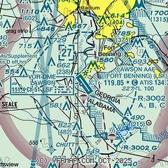
|
 Download PDF
of official airport diagram from the FAA
| Airport distance calculator |
|---|
|
|
| Sunrise and sunset |
|---|
|
Times for 07-Jun-2026
| | Local
(UTC-4) | | Zulu
(UTC) |
|---|
| Morning civil twilight | | 06:05 | | 10:05 |
| Sunrise | | 06:34 | | 10:34 |
| Sunset | | 20:44 | | 00:44 |
| Evening civil twilight | | 21:12 | | 01:12 |
|
| Current date and time |
|---|
| Zulu (UTC) | 07-Jun-2026 15:58:47 |
|---|
| Local (UTC-4) | 07-Jun-2026 11:58:47 |
|---|
|
| METAR |
|---|
| KLSF | 071455Z AUTO 19005KT 10SM FEW180 FEW210 28/23 A3001 RMK AO2 SLP165 T02840226 50005 $
|
KCSG
11nm N | 071551Z 20010KT 10SM CLR 28/21 A3004 RMK AO2 SLP167 T02780206
|
|
| TAF |
|---|
KCSG
11nm N | 071130Z 0712/0812 VRB03KT P6SM SCT070 BKN100 FM071500 21005KT P6SM SCT030 BKN050 FM071900 21006KT P6SM VCSH SCT025 BKN040 FM080000 VRB03KT P6SM SCT040 BKN080 FM080800 00000KT P6SM BKN020 BKN040
|
|
| NOTAMs |
|---|
NOTAMs are issued by the DoD/FAA and will open in a separate window not controlled by AirNav.
|
|


