FAA INFORMATION EFFECTIVE 11 JUNE 2026
Location
| FAA Identifier: | MBG |
| Lat/Long: | 45-32-46.6210N 100-24-22.5730W
45-32.777017N 100-24.376217W
45.5462836,-100.4062703
(estimated) |
| Elevation: | 1716.1 ft. / 523.1 m (surveyed) |
| Variation: | 09E (1990) |
| From city: | 1 mile NE of MOBRIDGE, SD |
| Time zone: | UTC -5 (UTC -6 during Standard Time) |
| Zip code: | 57601 |
Airport Operations
| Airport use: | Open to the public |
| Activation date: | 07/1959 |
| Control tower: | no |
| ARTCC: | MINNEAPOLIS CENTER |
| FSS: | HURON FLIGHT SERVICE STATION |
| NOTAMs facility: | MBG (NOTAM-D service available) |
| Attendance: | MON-FRI 0900-1800, ALL SAT ON CALL 0900-1800 FBO CLSD SUN |
| Wind indicator: | lighted |
| Segmented circle: | no |
| Lights: | ACTVT PAPI RWY 12 & 30; MIRL RWY 12/30 - CTAF. |
| Beacon: | white-green (lighted land airport)
Operates sunset to sunrise. |
Airport Communications
| CTAF/UNICOM: | 122.8 |
| WX ASOS: | 121.425 (605-206-3018) |
- APCH/DEP SVC PRVDD BY MINNEAPOLIS ARTCC (ZMP) ON FREQ 135.25/256.7 (DUPREE RCAG).
Airport Services
| Fuel available: | 100LL JET-A MOGAS |
| Parking: | hangars and tiedowns |
| Airframe service: | MINOR |
| Powerplant service: | MINOR |
| Bottled oxygen: | NONE |
| Bulk oxygen: | NONE |
Runway Information
Runway 12/30
| Dimensions: | 4410 x 75 ft. / 1344 x 23 m |
| Surface: | asphalt, in excellent condition |
| Weight bearing capacity: | |
| Runway edge lights: | medium intensity |
| RUNWAY 12 | | RUNWAY 30 |
| Latitude: | 45-33.007243N | | 45-32.573652N |
| Longitude: | 100-24.889393W | | 100-24.061338W |
| Elevation: | 1703.2 ft. | | 1700.0 ft. |
| Traffic pattern: | left | | left |
| Runway heading: | 118 magnetic, 127 true | | 298 magnetic, 307 true |
| Markings: | nonprecision, in fair condition | | nonprecision, in fair condition |
| Visual slope indicator: | 2-light PAPI on left (3.00 degrees glide path) | | 2-light PAPI on right (3.00 degrees glide path) |
| Runway end identifier lights: | no | | no |
| Touchdown point: | yes, no lights | | yes, no lights |
Runway 17/35
| Dimensions: | 2387 x 250 ft. / 728 x 76 m |
| Surface: | turf, in good condition
SOME GOPHER HOLES. |
| Operational restrictions: | RWY 17/35 CLSD WINTER MONTHS. |
| RUNWAY 17 | | RUNWAY 35 |
| Latitude: | 45-32.948530N | | 45-32.555815N |
| Longitude: | 100-24.194773W | | 100-24.191345W |
| Elevation: | 1716.1 ft. | | 1692.4 ft. |
| Traffic pattern: | left | | left |
| Runway heading: | 171 magnetic, 180 true | | 351 magnetic, 360 true |
| Markings: | none, in fair condition | | none, in fair condition |
| Runway end identifier lights: | no | | no |
| Touchdown point: | yes, no lights | | yes, no lights |
| Obstructions: | 43 ft. road, 882 ft. from runway, 20:1 slope to clear | | none |
Airport Ownership and Management from official FAA records
| Ownership: | Publicly-owned |
| Owner: | CITY OF MOBRIDGE
114 1ST AVE. E
MOBRIDGE, SD 57601
Phone 605-845-3509 |
| Manager: | BRADY FUHRER
114 1ST AVENUE E
MOBRIDGE, SD 57601
Phone 605-850-9935 |
Additional Remarks
| - | WILDLIFE ON AND INVOF ARPT. |
| - | GCO AVBL ON FREQ 121.725 (4 CLICKS TO MINNEAPOLIS CENTER) |
| - | FOR CD IF UNA TO CTC ON FSS FREQ, CTC MINNEAPOLIS ARTCC AT 651-463-5588. |
Instrument Procedures
NOTE: All procedures below are presented as PDF files. If you need a reader for these files, you should download the free Adobe Reader.NOT FOR NAVIGATION. Please procure official charts for flight.
FAA instrument procedures published for use from 11 June 2026 at 0901Z to 09 July 2026 at 0900z.
IAPs - Instrument Approach Procedures |
|---|
| RNAV (GPS) RWY 12 | |
download (228KB) |
| RNAV (GPS) RWY 30 | |
download (291KB) |
| NOTE: Special Alternate Minimums apply | |
download (25KB) |
| NOTE: Special Take-Off Minimums/Departure Procedures apply | |
download (156KB) |
Other nearby airports with instrument procedures:
0D8 - Gettysburg Municipal Airport (39 nm SE)
7L2 - Linton Municipal Airport (41 nm N)
84D - Cheyenne Eagle Butte Airport (49 nm SW)
98D - Onida Municipal Airport (52 nm S)
KASY - Ashley Municipal Airport (53 nm NE)
|
|

Road maps at:
MapQuest
Bing
Google
| Aerial photo |
|---|
WARNING: Photo may not be current or correct
 Photo by Steve Hamilton
Photo taken 28-Aug-2011
looking north.
Photo by Steve Hamilton
Photo taken 28-Aug-2011
looking north.
Do you have a better or more recent aerial photo of Mobridge Municipal Airport that you would like to share? If so, please send us your photo.
|
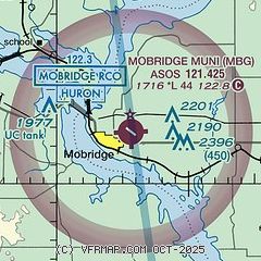
| Sectional chart |
|---|
|
| Airport distance calculator |
|---|
|
|
| Sunrise and sunset |
|---|
|
Times for 12-Jun-2026
| | Local
(UTC-5) | | Zulu
(UTC) |
|---|
| Morning civil twilight | | 05:15 | | 10:15 |
| Sunrise | | 05:53 | | 10:53 |
| Sunset | | 21:30 | | 02:30 |
| Evening civil twilight | | 22:08 | | 03:08 |
|
| Current date and time |
|---|
| Zulu (UTC) | 12-Jun-2026 13:33:31 |
|---|
| Local (UTC-5) | 12-Jun-2026 08:33:31 |
|---|
|
| METAR |
|---|
| KMBG | 121252Z AUTO 25004KT 10SM CLR 14/09 A2990 RMK AO2 SLP120 T01390089
|
|
| TAF |
|---|
| KMBG | 121120Z 1212/1312 VRB04KT P6SM SKC FM121700 29012G19KT P6SM FEW240 FM130200 33010G18KT P6SM SCT250
|
|
| NOTAMs |
|---|
NOTAMs are issued by the DoD/FAA and will open in a separate window not controlled by AirNav.
|
|

