FAA INFORMATION EFFECTIVE 14 MAY 2026
Location
| FAA Identifier: | MSN |
| Lat/Long: | 43-08-23.5649N 089-20-15.0161W
43-08.392748N 089-20.250268W
43.1398791,-89.3375045
(estimated) |
| Elevation: | 886.6 ft. / 270.2 m (surveyed) |
| Variation: | 03W (2020) |
| From city: | 5 miles NE of MADISON, WI |
| Time zone: | UTC -5 (UTC -6 during Standard Time) |
| Zip code: | 53704 |
Airport Operations
| Airport use: | Open to the public |
| Activation date: | 09/1937 |
| Control tower: | yes |
| ARTCC: | CHICAGO CENTER |
| FSS: | GREEN BAY FLIGHT SERVICE STATION |
| NOTAMs facility: | MSN (NOTAM-D service available) |
| Attendance: | CONTINUOUS |
| Pattern altitude: | MILITARY: OVHD TFC PAT ALT RSTRD TO 3500 FT MSL; RWY 18/36 L TURN. |
| Wind indicator: | lighted |
| Segmented circle: | no |
| Lights: | ACTVT MALSR RWY 18 & 21; REIL RWY 03, 14 & 32; HIRL RWY 03/21, 14/32 & 18/36 - CTAF. WHEN ATCT CLSD HIRL RWY 18/36 PRESET LOW INTST; INCR INTST - CTAF. |
| Beacon: | white-green (lighted land airport)
Operates sunset to sunrise. |
| Fire and rescue: | ARFF index C |
Airport Communications
| CTAF: | 119.3 |
| UNICOM: | 122.95 |
| ATIS: | 124.65 278.3 |
| WX ASOS: | PHONE 608-410-1285 |
| MADISON GROUND: | 121.9 348.6 [0600-2300] |
| MADISON TOWER: | 119.3 257.8 [0600-2300] |
| MADISON APPROACH: | 120.1 ;EAST 135.45 ;WEST 343.7 ;WEST 350.3 ;EAST [0600-2300] |
| MADISON DEPARTURE: | 120.1 ;EAST 135.45 ;WEST 318.1 [0600-2300] |
| CLEARANCE DELIVERY: | 121.625 |
| ANG OPS: | 123.4 138.175 238.2 299.9 40.8 |
| CLASS C: | 120.1 ;EAST 135.45 ;WEST 343.7 ;WEST 350.3 ;EAST |
| EMERG: | 121.5 243.0 |
| IC: | 343.7 ;WEST |
| WX AWOS-3 at C29 (9 nm W): | 118.675 (608-833-1686) |
- ARMY OPERATION CALL 'FIREFLY'. 0730-1600 LCL.
- APCH/DEP SVC PRVDD BY CHICAGO ARTCC ON FREQS 133.3/257.925 (LONE ROCK RCAG) & 135.45 WHEN MADISON APCH CTL CLSD.
- CALL MADISON OPS
Nearby radio navigation aids
| VOR radial/distance | | VOR name | | Freq | | Var |
|---|
| MSN at field | | MADISON VORTAC | | 108.60 | | 03E |
| DLLr140/30.9 | | DELLS VORTAC | | 117.00 | | 03E |
| JVLr341/36.4 | | JANESVILLE VOR/DME | | 114.30 | | 03E |
| NDB name | | Hdg/Dist | | Freq | | Var | | ID |
|---|
| ROCK RIVER | | 267/26.9 | | 371 | | 01W | | RYV | .-. -.-- ...- |
Airport Services
| Fuel available: | 100LL JET-A JET-A++ |
| Parking: | hangars |
| Airframe service: | MAJOR |
| Powerplant service: | MAJOR |
| Bottled oxygen: | HIGH/LOW |
Runway Information
Runway 18/36
| Dimensions: | 9006 x 150 ft. / 2745 x 46 m |
| Surface: | concrete/grooved, in fair condition |
| Weight bearing capacity: | | Single wheel: | 120.0 | | Double wheel: | 230.0 | | Double tandem: | 380.0 | | Dual double tandem: | 870.0 |
|
| Runway edge lights: | high intensity |
| RUNWAY 18 | | RUNWAY 36 |
| Latitude: | 43-08.948228N | | 43-07.466638N |
| Longitude: | 089-20.461530W | | 089-20.529960W |
| Elevation: | 860.3 ft. | | 862.0 ft. |
| Traffic pattern: | left | | left |
| Runway heading: | 185 magnetic, 182 true | | 005 magnetic, 002 true |
| Displaced threshold: | 400 ft. | | 1001 ft. |
| Declared distances: | TORA:9006 TODA:9006 ASDA:9006 LDA:8606 | | TORA:9006 TODA:9006 ASDA:9006 LDA:8006 |
| Markings: | precision, in good condition | | precision, in good condition |
| Visual slope indicator: | 4-light PAPI on left (3.00 degrees glide path)
UNUSBL BYD 9 DEGS RIGHT OF CNTRLN. | | 4-light PAPI on left (3.00 degrees glide path) |
| RVR equipment: | touchdown, midfield, rollout
RWY CC NOT REPORTED. | | touchdown, midfield, rollout
RWY CC NOT REPORTED. |
| Approach lights: | MALSR: 1,400 foot medium intensity approach lighting system with runway alignment indicator lights | | ALSF2: standard 2,400 foot high intensity approach lighting system with centerline sequenced flashers (category II or III)
ALSF2 OPRS AS SSALR WHEN TWR CLSD. |
| Runway end identifier lights: | no | | no |
| Centerline lights: | yes | | yes |
| Touchdown point: | yes, no lights | | yes, no lights |
| Instrument approach: | ILS/DME | | ILS/DME |
| Obstructions: | 50 ft. hill, 1634 ft. from runway, 689 ft. left of centerline, 28:1 slope to clear
APCH RATIO 40:1 FM DTHR. | | none |
Runway 3/21
| Dimensions: | 7200 x 150 ft. / 2195 x 46 m |
| Surface: | concrete/grooved, in good condition |
| Weight bearing capacity: | | Single wheel: | 120.0 | | Double wheel: | 230.0 | | Double tandem: | 380.0 |
|
| Runway edge lights: | high intensity |
| RUNWAY 3 | | RUNWAY 21 |
| Latitude: | 43-07.998117N | | 43-09.034818N |
| Longitude: | 089-20.505437W | | 089-19.720958W |
| Elevation: | 860.8 ft. | | 886.6 ft. |
| Traffic pattern: | left | | left |
| Runway heading: | 032 magnetic, 029 true | | 212 magnetic, 209 true |
| Displaced threshold: | 431 ft. | | no |
| Declared distances: | TORA:7200 TODA:7200 ASDA:7200 LDA:6770 | | TORA:6770 TODA:6770 ASDA:7015 LDA:7015 |
| Markings: | precision, in good condition | | precision, in good condition |
| Visual slope indicator: | 4-light PAPI on left (3.00 degrees glide path) | | 4-light PAPI on left (3.00 degrees glide path) |
| Approach lights: | | | MALSR: 1,400 foot medium intensity approach lighting system with runway alignment indicator lights |
| Runway end identifier lights: | yes | | |
| Touchdown point: | yes, no lights | | yes, no lights |
| Instrument approach: | | | ILS/DME |
| Obstructions: | 72 ft. trees, 2760 ft. from runway, 460 ft. left of centerline, 35:1 slope to clear
TAP | | 19 ft. road, 2050 ft. from runway |
Runway 14/32
| Dimensions: | 5846 x 150 ft. / 1782 x 46 m |
| Surface: | concrete/grooved, in good condition |
| Weight bearing capacity: | | Single wheel: | 120.0 | | Double wheel: | 210.0 | | Double tandem: | 320.0 |
|
| Runway edge lights: | high intensity |
| RUNWAY 14 | | RUNWAY 32 |
| Latitude: | 43-08.874538N | | 43-08.177185N |
| Longitude: | 089-20.493760W | | 089-19.588083W |
| Elevation: | 858.9 ft. | | 861.5 ft. |
| Traffic pattern: | left | | left |
| Runway heading: | 139 magnetic, 136 true | | 319 magnetic, 316 true |
| Displaced threshold: | 477 ft. | | no |
| Declared distances: | TORA:5846 TODA:5846 ASDA:5846 LDA:5369 | | TORA:5846 TODA:5846 ASDA:5846 LDA:5846 |
| Markings: | nonprecision, in good condition | | nonprecision, in good condition |
| Visual slope indicator: | 4-light PAPI on left (3.00 degrees glide path) | | 4-light PAPI on left (3.00 degrees glide path) |
| Runway end identifier lights: | yes | | yes |
| Touchdown point: | yes, no lights | | yes, no lights |
| Obstructions: | none | | 112 ft. tree, 4047 ft. from runway, 440 ft. right of centerline, 34:1 slope to clear |
Airport Ownership and Management from official FAA records
| Ownership: | Publicly-owned |
| Owner: | DANE COUNTY
4000 INTERNATIONAL LANE
MADISON, WI 53704
Phone 608-246-3380 |
| Manager: | MARK PAPKO
4000 INTERNATIONAL LANE
MADISON, WI 53704
Phone 605-246-3390
MATT POWERS - 608-661-6452 |
Additional Remarks
| A39-18/36 | PCR VALUE: 780/R/C/W/T |
| A39-14/32 | PCR VALUE: 710/R/D/W/T |
| A39-03/21 | PCR VALUE: 780/R/D/W/T |
| E60-21 | BAK-14 BAK-12(B) (1620'). |
| E60-18 | BAK-14 BAK-12(B) (1900'). |
| E60-36 | BAK-14 BAK-12(B) (1750'). |
| - | W RAMP RSTRD TO ACR. |
| - | ANG: PPR - 115FW.PPR.ORG@US.AF.MIL. OPS HR 1200-2230Z++MON-THURS - D724-8642/8436/C608 245-4642/4436. H24 - D724-8580 H24/C608 245-4580. |
| - | AVOID OTFC OF YAHARA RIVER INVOF ARPT BLW 2000 FT. |
| - | RWY 14 & 18 APCH ENDS CLOSELY ALIGNED; VERIFY RWY & HDG BFR DEP. |
| - | TWY L1, L6, B5, E & H NORTH OF RWY 14/32, E RAMP BTN TWY H & M CLSD TO WINGSPAN GTR THAN 118 FT. TWYS B1, J & B NORTH OF TWY M & E RAMP CLSD TO WINGSPAN GTR THAN 150 FT. |
| - | NOISE ABATEMENT PROC IN EFCT; DEP RWY 03 & 36; ARR RWY 18 & 21. |
| - | ARNG: PPR; TSNT SVC LTD; HEL RQR SVC - ARMY OPS; 1300-2200Z++ MON, TUE; 1300-0400Z++ WED-FRI, CLSD SAT, SUN - D745-8310/C608-301-8310. |
| - | HIGH RISK FLT TEST PPR - AMGR. |
| - | ENG RUNUP N HOLD BAY ONLY. |
| - | BARRICADES ALG W EDGE OF S RAMP ADJ MIL RAMP. |
| - | W RAMP UNCTLD; PUSHBACK AT PILOT DISCRETION. |
| - | AVGAS E OR S APRON ONLY. |
| - | RWY 18, 21, 36 BAK-14 ARRESTING CABLE MIL USE ONLY; RETRACTED WHEN NOT IN USE. |
| - | FOR CD CTC MADISON APP/DEP CON AT 608-249-8240. WHEN MADISON APCH CLSD, FOR CD CTC CHICAGO ARTCC AT 630-906-8921. |
| - | TWY F MIL FIGHTER USE ONLY. TWY G PERM CLSD. |
| - | GEN AVN SVC AVBL E RAMP ONLY. |
| - | TBJT TRNG OPS PROH. |
| - | BIRDS ON & INVOF ARPT. |
Instrument Procedures
NOTE: All procedures below are presented as PDF files. If you need a reader for these files, you should download the free Adobe Reader.NOT FOR NAVIGATION. Please procure official charts for flight.
FAA instrument procedures published for use from 14 May 2026 at 0901Z to 11 June 2026 at 0900Z.
IAPs - Instrument Approach Procedures |
|---|
| ILS OR LOC RWY 18 | |
download (313KB) |
| ILS OR LOC RWY 21 **CHANGED** | |
download (258KB) |
| ILS OR LOC/DME RWY 36 | |
download (283KB) |
| ILS RWY 36 (SA CAT I) | |
download (248KB) |
| ILS RWY 18 (SA CAT I - II) | |
download (300KB) |
| ILS RWY 36 (CAT II - III) | |
download (258KB) |
| RNAV (GPS) RWY 03 | |
download (240KB) |
| RNAV (GPS) RWY 14 | |
download (255KB) |
| RNAV (GPS) RWY 18 | |
download (270KB) |
| RNAV (GPS) RWY 21 | |
download (244KB) |
| RNAV (GPS) RWY 32 | |
download (247KB) |
| RNAV (GPS) RWY 36 | |
download (292KB) |
| VOR RWY 14 | |
download (219KB) |
| VOR RWY 32 | |
download (207KB) |
| HI-TACAN RWY 18 | |
download (147KB) |
| HI-TACAN RWY 36 | |
download (137KB) |
| NOTE: Special Alternate Minimums apply | |
download (163KB) |
| NOTE: Special Take-Off Minimums/Departure Procedures apply | |
download (518KB) |
Other nearby airports with instrument procedures:
87Y - Blackhawk Airfield (7 nm E)
C29 - Middleton Municipal Airport - Morey Field (9 nm W)
91C - Sauk/Prairie Airport (21 nm NW)
61C - Fort Atkinson Municipal Airport (25 nm SE)
C47 - Portage Municipal Airport (26 nm N)
|
|

Road maps at:
MapQuest
Bing
Google
| Aerial photo |
|---|
WARNING: Photo may not be current or correct
 Photo by Brian Mensing
Photo taken 19-Aug-2020
looking northwest.
Photo by Brian Mensing
Photo taken 19-Aug-2020
looking northwest.
Do you have a better or more recent aerial photo of Dane County Regional Airport-Truax Field that you would like to share? If so, please send us your photo.
|
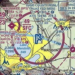
| Sectional chart |
|---|
|
 Download PDF
of official airport diagram from the FAA
| Airport distance calculator |
|---|
|
|
| Sunrise and sunset |
|---|
|
Times for 10-Jun-2026
| | Local
(UTC-5) | | Zulu
(UTC) |
|---|
| Morning civil twilight | | 04:43 | | 09:43 |
| Sunrise | | 05:18 | | 10:18 |
| Sunset | | 20:35 | | 01:35 |
| Evening civil twilight | | 21:10 | | 02:10 |
|
| Current date and time |
|---|
| Zulu (UTC) | 10-Jun-2026 18:36:59 |
|---|
| Local (UTC-5) | 10-Jun-2026 13:36:59 |
|---|
|
| METAR |
|---|
| KMSN | 101753Z 18012G18KT 10SM BKN034 BKN250 31/23 A2963 RMK AO2 SLP027 T03060228 10306 20239 58031
|
KC29
9nm W | 101815Z AUTO 19008G14KT 10SM SCT037 BKN043 31/21 A2967 RMK AO1 T03060207
|
|
| TAF |
|---|
| KMSN | 101745Z 1018/1118 20012KT P6SM BKN030 FM101900 21013G25KT 2SM +TSRA BKN025CB FM102100 21013G25KT P6SM BKN040 PROB30 1021/1022 5SM -TSRA BKN025CB FM110000 21011G22KT P6SM BKN025 PROB30 1100/1106 5SM -TSRA OVC020CB FM110600 23007KT P6SM SCT070 FM111600 18007KT 5SM -SHRA BKN060 PROB30 1116/1118 3SM TSRA BKN035CB
|
|
| NOTAMs |
|---|
NOTAMs are issued by the DoD/FAA and will open in a separate window not controlled by AirNav.
|
|


