FAA INFORMATION EFFECTIVE 14 MAY 2026
Location
| FAA Identifier: | OLZ |
| Lat/Long: | 42-40-51.3282N 091-58-27.8234W
42-40.855470N 091-58.463723W
42.6809245,-91.9743954
(estimated) |
| Elevation: | 1076.3 ft. / 328.1 m (surveyed) |
| Variation: | 02E (1985) |
| From city: | 3 miles W of OELWEIN, IA |
| Time zone: | UTC -5 (UTC -6 during Standard Time) |
| Zip code: | 50662 |
Airport Operations
| Airport use: | Open to the public |
| Activation date: | 12/1946 |
| Control tower: | no |
| ARTCC: | MINNEAPOLIS CENTER |
| FSS: | FORT DODGE FLIGHT SERVICE STATION |
| NOTAMs facility: | OLZ (NOTAM-D service available) |
| Attendance: | UNATNDD |
| Wind indicator: | lighted |
| Segmented circle: | no |
| Lights: | ACTVT MIRL RY 13/31 & REIL RY 13/31 CTAF. |
| Beacon: | white-green (lighted land airport)
Operates sunset to sunrise. |
Airport Communications
| CTAF/UNICOM: | 122.8 |
| WX AWOS-3: | 119.675 (319-283-3518) |
| DES MOINES APPROACH: | 118.9 |
| DES MOINES DEPARTURE: | 118.9 |
| WX AWOS-3 at IIB (13 nm S): | 120.825 (319-334-3879) |
- APCH/DEP SVC PRVDD BY MINNEAPOLIS ARTCC ON FREQS 118.9/251.15 (REMOTED FROM WATERLOO) WHEN DES MOINES APCH CTL CLSD.
Nearby radio navigation aids
| VOR radial/distance | | VOR name | | Freq | | Var |
|---|
| ALOr068/20.2 | | WATERLOO VOR/DME | | 112.20 | | 00E |
Airport Services
| Fuel available: | 100LL JET-A |
| Parking: | hangars and tiedowns |
| Airframe service: | MAJOR |
| Powerplant service: | MAJOR |
| Bottled oxygen: | NONE |
| Bulk oxygen: | NONE |
Runway Information
Runway 13/31
| Dimensions: | 4000 x 75 ft. / 1219 x 23 m |
| Surface: | concrete/wired/combed, in good condition |
| Weight bearing capacity: | |
| Runway edge lights: | medium intensity |
| RUNWAY 13 | | RUNWAY 31 |
| Latitude: | 42-41.047712N | | 42-40.586070N |
| Longitude: | 091-58.801773W | | 091-58.165505W |
| Elevation: | 1076.3 ft. | | 1059.3 ft. |
| Traffic pattern: | left | | left |
| Runway heading: | 133 magnetic, 135 true | | 313 magnetic, 315 true |
| Markings: | nonprecision, in fair condition | | nonprecision, in fair condition |
| Runway end identifier lights: | yes | | yes |
| Touchdown point: | yes, no lights | | yes, no lights |
| Obstructions: | 17 ft. road, 480 ft. from runway, 290 ft. right of centerline, 16:1 slope to clear | | none |
Runway 18/36
| Dimensions: | 1822 x 85 ft. / 555 x 26 m |
| Surface: | turf, in fair condition |
| Runway edge markings: | & 36 THLDS & EDGES MARKED WITH YELLOW CONES. |
| RUNWAY 18 | | RUNWAY 36 |
| Latitude: | 42-41.090000N | | 42-40.790333N |
| Longitude: | 091-58.412333W | | 091-58.427667W |
| Elevation: | 1075.0 ft. | | 1073.0 ft. |
| Traffic pattern: | left | | left |
| Runway heading: | 180 magnetic, 182 true | | 000 magnetic, 002 true |
| Touchdown point: | yes, no lights | | yes, no lights |
| Obstructions: | 10 ft. road, 390 ft. from runway, 39:1 slope to clear | | none |
Airport Ownership and Management from official FAA records
| Ownership: | Publicly-owned |
| Owner: | CITY OF OELWEIN
20 2ND AVE SW
OELWEIN, IA 50662
Phone 319-283-5440 |
| Manager: | DYLAN MULFINGER
20 - 2ND AVENUE SW
OELWEIN, IA 50662
Phone (319) 283-5440 |
Additional Remarks
| - | RWY 18/36 CLSD AFT FST SNWFL. |
| - | AG OPS DRG SUMMER MONTHS |
| - | FOR CD CTC DES MOINES APCH AT 515-974-8016. WHEN DES MOINES APP CLSD, FOR CD CTC MINNEAPOLIS ARTCC AT 651-463-5588. |
Instrument Procedures
NOTE: All procedures below are presented as PDF files. If you need a reader for these files, you should download the free Adobe Reader.NOT FOR NAVIGATION. Please procure official charts for flight.
FAA instrument procedures published for use from 14 May 2026 at 0901Z to 11 June 2026 at 0900Z.
IAPs - Instrument Approach Procedures |
|---|
| RNAV (GPS) RWY 13 | |
download (193KB) |
| NOTE: Special Alternate Minimums apply | |
download (124KB) |
| NOTE: Special Take-Off Minimums/Departure Procedures apply | |
download (435KB) |
Other nearby airports with instrument procedures:
KIIB - James H Connell Field at Independence Municipal Airport (13 nm S)
3Y2 - George L Scott Municipal Airport (20 nm NE)
KALO - Waterloo Regional Airport (20 nm W)
C25 - Waverly Municipal Airport (24 nm W)
KVTI - Vinton Veterans Memorial Airpark (28 nm S)
|
|

Road maps at:
MapQuest
Bing
Google
| Aerial photo |
|---|
WARNING: Photo may not be current or correct
 Photo by David Ekman
Photo taken 04-Sep-2020
looking north.
Photo by David Ekman
Photo taken 04-Sep-2020
looking north.
Do you have a better or more recent aerial photo of Oelwein Municipal Airport that you would like to share? If so, please send us your photo.
|
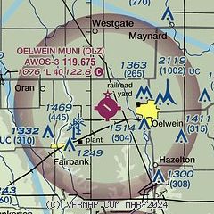
| Sectional chart |
|---|
|
| Airport distance calculator |
|---|
|
|
| Sunrise and sunset |
|---|
|
Times for 03-Jun-2026
| | Local
(UTC-5) | | Zulu
(UTC) |
|---|
| Morning civil twilight | | 04:58 | | 09:58 |
| Sunrise | | 05:33 | | 10:33 |
| Sunset | | 20:39 | | 01:39 |
| Evening civil twilight | | 21:14 | | 02:14 |
|
| Current date and time |
|---|
| Zulu (UTC) | 03-Jun-2026 09:51:41 |
|---|
| Local (UTC-5) | 03-Jun-2026 04:51:41 |
|---|
|
| METAR |
|---|
| KOLZ | 030935Z AUTO 13010KT 10SM CLR 15/06 A3031 RMK A01
|
KIIB
14nm S | 030935Z AUTO 11007KT 10SM CLR 13/07 A3033 RMK AO2 T01280068
|
|
| TAF |
|---|
KALO
20nm SW | 030520Z 0306/0406 11007KT P6SM FEW250 FM031200 15009KT P6SM FEW250 FM031600 17012G18KT P6SM FEW250 FM040100 16010KT P6SM FEW200
|
|
| NOTAMs |
|---|
NOTAMs are issued by the DoD/FAA and will open in a separate window not controlled by AirNav.
|
|

