FAA INFORMATION EFFECTIVE 14 MAY 2026
Location
| FAA Identifier: | PVW |
| Lat/Long: | 34-10-05.3300N 101-43-02.4100W
34-10.088833N 101-43.040167W
34.1681472,-101.7173361
(estimated) |
| Elevation: | 3374 ft. / 1028.4 m (surveyed) |
| Variation: | 09E (2000) |
| From city: | 1 mile S of PLAINVIEW, TX |
| Time zone: | UTC -5 (UTC -6 during Standard Time) |
| Zip code: | 79072 |
Airport Operations
| Airport use: | Open to the public |
| Activation date: | 04/1945 |
| Control tower: | no |
| ARTCC: | FORT WORTH CENTER |
| FSS: | FORT WORTH FLIGHT SERVICE STATION |
| NOTAMs facility: | PVW (NOTAM-D service available) |
| Attendance: | 0800-1800
UNATNDD THANKSGIVING & CHRISTMAS. |
| Wind indicator: | lighted |
| Segmented circle: | yes |
| Lights: | MIRL RWY 4/22, RWY 13/31 SS-SR, PRESET LOW INTST. TO INCR INTST AND ACTVT REIL RWY 4; VASI RWY 22 - CTAF. VASI RWY 4 OPR CONSLY. |
| Beacon: | white-green (lighted land airport)
Operates sunset to sunrise. |
Airport Communications
| CTAF/UNICOM: | 123.0 |
| WX AWOS-3: | 119.675 (806-291-8679) |
| LUBBOCK APPROACH: | 119.2 119.9 |
| LUBBOCK DEPARTURE: | 119.2 119.9 |
| CLEARANCE DELIVERY: | 118.4 |
Nearby radio navigation aids
| VOR radial/distance | | VOR name | | Freq | | Var |
|---|
| PVWr025/6.1 | | PLAINVIEW VOR/DME | | 112.90 | | 11E |
| LBBr008/29.5 | | LUBBOCK VORTAC | | 109.20 | | 11E |
Airport Services
| Fuel available: | 100LL JET-A1+ |
| Parking: | hangars and tiedowns |
| Airframe service: | NONE |
| Powerplant service: | NONE |
Runway Information
Runway 4/22
| Dimensions: | 5997 x 100 ft. / 1828 x 30 m |
| Surface: | asphalt, in fair condition
TRANSVERSE AND LONGL CRACKS UP TO 4 IN WID, FULL LEN. |
| Weight bearing capacity: | |
| Runway edge lights: | medium intensity |
| RUNWAY 4 | | RUNWAY 22 |
| Latitude: | 34-09.744000N | | 34-10.369817N |
| Longitude: | 101-43.555350W | | 101-42.634683W |
| Elevation: | 3372.6 ft. | | 3366.4 ft. |
| Traffic pattern: | left | | left |
| Runway heading: | 042 magnetic, 051 true | | 222 magnetic, 231 true |
| Markings: | nonprecision, in good condition | | nonprecision, in good condition |
| Visual slope indicator: | 4-box VASI on left (3.50 degrees glide path)
UNUSBL BYD 7 DEG LEFT OF RWY CNTRLN. | | 4-box VASI on left (3.50 degrees glide path) |
| Runway end identifier lights: | yes | | yes |
| Touchdown point: | yes, no lights | | yes, no lights |
| Obstructions: | 44 ft. pole, 2073 ft. from runway, 42:1 slope to clear | | 190 ft. bldg, lighted, 6200 ft. from runway, 800 ft. right of centerline, 31:1 slope to clear
GRAIN ELEVATOR |
Runway 13/31
| Dimensions: | 4000 x 100 ft. / 1219 x 30 m |
| Surface: | asphalt, in excellent condition |
| Weight bearing capacity: | |
| Runway edge lights: | medium intensity |
| RUNWAY 13 | | RUNWAY 31 |
| Latitude: | 34-10.382017N | | 34-09.891733N |
| Longitude: | 101-43.222767W | | 101-42.692267W |
| Elevation: | 3372.4 ft. | | 3372.4 ft. |
| Traffic pattern: | left | | left |
| Runway heading: | 129 magnetic, 138 true | | 309 magnetic, 318 true |
| Markings: | nonprecision, in good condition | | nonprecision, in good condition |
| Touchdown point: | yes, no lights | | yes, no lights |
| Obstructions: | 40 ft. pline, 1120 ft. from runway, 205 ft. left of centerline, 23:1 slope to clear | | 15 ft. road, 585 ft. from runway, 172 ft. right of centerline, 25:1 slope to clear |
Airport Ownership and Management from official FAA records
| Ownership: | Publicly-owned |
| Owner: | CITY OF PLAINVIEW & HALE CO.
500 BROADWAY 300
PLAINVIEW, TX 79072
Phone 806-291-5294 |
| Manager: | RYAN STEVENSON
10 MILLER BLVD
PLAINVIEW, TX 79072-1600
Phone 806-293-4121 |
Additional Remarks
| - | NO LINE OF SIGHT TO RWY 13/31 FM RWY END 22. |
| - | FOR CD IF UNA TO CTC ON FSS FREQ, CTC FORT WORTH ARTCC AT 817-858-7584. |
Instrument Procedures
NOTE: All procedures below are presented as PDF files. If you need a reader for these files, you should download the free Adobe Reader.NOT FOR NAVIGATION. Please procure official charts for flight.
FAA instrument procedures published for use from 14 May 2026 at 0901Z to 11 June 2026 at 0900Z.
IAPs - Instrument Approach Procedures |
|---|
| RNAV (GPS) RWY 04 | |
download (231KB) |
| RNAV (GPS) RWY 22 | |
download (202KB) |
| VOR RWY 04 | |
download (199KB) |
| NOTE: Special Alternate Minimums apply | |
download (117KB) |
| NOTE: Special Take-Off Minimums/Departure Procedures apply | |
download (113KB) |
Other nearby airports with instrument procedures:
41F - Floydada Municipal Airport (22 nm SE)
KLBB - Lubbock Preston Smith International Airport (31 nm S)
KLIU - Littlefield Taylor Brown Municipal Airport (36 nm SW)
8F3 - Crosbyton Municipal Airport (40 nm SE)
F49 - City of Slaton/Larry T Neal Memorial Airport (41 nm S)
|
|

Road maps at:
MapQuest
Bing
Google
| Aerial photo |
|---|
WARNING: Photo may not be current or correct
 Photo taken 28-Apr-2007
Do you have a better or more recent aerial photo of Hale County Airport that you would like to share? If so, please send us your photo.
|
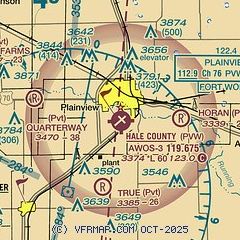
| Sectional chart |
|---|
|
CAUTION: Diagram may not be current

| Airport distance calculator |
|---|
|
|
| Sunrise and sunset |
|---|
|
Times for 23-May-2026
| | Local
(UTC-5) | | Zulu
(UTC) |
|---|
| Morning civil twilight | | 06:13 | | 11:13 |
| Sunrise | | 06:41 | | 11:41 |
| Sunset | | 20:46 | | 01:46 |
| Evening civil twilight | | 21:15 | | 02:15 |
|
| Current date and time |
|---|
| Zulu (UTC) | 23-May-2026 15:34:34 |
|---|
| Local (UTC-5) | 23-May-2026 10:34:34 |
|---|
|
| METAR |
|---|
| KPVW | 231510Z AUTO 09008KT 10SM CLR 19/11 A3006 RMK AO2 T01900114
|
|
| TAF |
|---|
| KPVW | 231120Z 2312/2412 36005KT P6SM FEW050 FM231800 15009KT P6SM SCT050 FM240000 12015KT P6SM BKN100 PROB30 2400/2404 P6SM -TSRA OVC040CB FM240500 13009KT P6SM OVC250 AMD NOT SKED
|
|
| NOTAMs |
|---|
NOTAMs are issued by the DoD/FAA and will open in a separate window not controlled by AirNav.
|
|


