FAA INFORMATION EFFECTIVE 14 MAY 2026
Location
| FAA Identifier: | RSN |
| Lat/Long: | 32-30-47.6090N 092-35-18.4010W
32-30.793483N 092-35.306683W
32.5132247,-92.5884447
(estimated) |
| Elevation: | 316.8 ft. / 97 m (estimated) |
| Variation: | 03E (1995) |
| From city: | 3 miles E of RUSTON, LA |
| Time zone: | UTC -5 (UTC -6 during Standard Time) |
| Zip code: | 71270 |
Airport Operations
| Airport use: | Open to the public |
| Activation date: | 01/1994 |
| Control tower: | no |
| ARTCC: | FORT WORTH CENTER |
| FSS: | DE RIDDER FLIGHT SERVICE STATION |
| NOTAMs facility: | RSN (NOTAM-D service available) |
| Attendance: | 0700-1900 |
| Pattern altitude: | 1316.8 ft. MSL |
| Wind indicator: | lighted |
| Segmented circle: | yes |
| Lights: | REIL RWY 18 & 36; MIRL RWY 18/36 - PRESET LOW INTST DUSK-DAWN; TO INCR INTST ACTVT - CTAF. |
| Beacon: | white-green (lighted land airport)
Operates sunset to sunrise. |
Airport Communications
| CTAF/UNICOM: | 122.7 |
| WX AWOS-3PT: | 119.525 (318-242-0062) |
| MONROE APPROACH: | 126.9 |
| MONROE DEPARTURE: | 126.9 |
| CLEARANCE DELIVERY: | 118.8 |
- APCH/DEP CTL SVC PRVDD BY FORT WORTH ARTCC (ZFW) ON FREQS 126.325/346.25 (MONROE RCAG) WHEN MONROE APCH CTL (MLU) CLSD.
Nearby radio navigation aids
| VOR radial/distance | | VOR name | | Freq | | Var |
|---|
| MLUr267/28.0 | | MONROE VORTAC | | 117.20 | | 03E |
| NDB name | | Hdg/Dist | | Freq | | Var | | ID |
|---|
| BASTROP | | 245/38.5 | | 329 | | 03E | | BQP | -... --.- .--. |
Airport Services
| Fuel available: | 100LL JET-A
100LL:FOR FUEL AFTER HOURS CALL IN ADVANCE DURING WORKING HOURS 318-251-9098. |
| Parking: | hangars and tiedowns |
| Airframe service: | MINOR |
| Powerplant service: | MINOR |
| Bottled oxygen: | NONE |
| Bulk oxygen: | NONE |
Runway Information
Runway 18/36
| Dimensions: | 6002 x 100 ft. / 1829 x 30 m |
| Surface: | asphalt, in excellent condition |
| Weight bearing capacity: | | PCN 30 /F/B/X/T | | Single wheel: | 78.0 | | Double wheel: | 119.0 |
|
| Runway edge lights: | medium intensity |
| RUNWAY 18 | | RUNWAY 36 |
| Latitude: | 32-31.288370N | | 32-30.298597N |
| Longitude: | 092-35.306015W | | 092-35.307367W |
| Elevation: | 276.2 ft. | | 316.8 ft. |
| Traffic pattern: | left | | left |
| Runway heading: | 177 magnetic, 180 true | | 357 magnetic, 000 true |
| Markings: | nonprecision, in fair condition | | nonprecision, in fair condition |
| Visual slope indicator: | 4-light PAPI on left (3.00 degrees glide path) | | 4-light PAPI on left (3.00 degrees glide path) |
| Runway end identifier lights: | yes | | yes |
| Touchdown point: | yes, no lights | | yes, no lights |
| Obstructions: | 60 ft. trees, 2383 ft. from runway, 450 ft. left of centerline, 36:1 slope to clear | | none |
Airport Ownership and Management from official FAA records
| Ownership: | Publicly-owned |
| Owner: | CITY OF RUSTON
401 N. TRENTON
RUSTON, LA 71270
Phone 318-251-8620 |
| Manager: | JOHN FREEMAN
701 E. TENNESSEE AVE, PO BOX 2069
RUSTON, LA 71270
Phone 318-242-7703
DIRECTOR OF PUBLIC WORKS |
Additional Remarks
| - | NUMEROUS TRNG ACFT IN VICINITY. |
| - | MEN AND EQUIPMENT OPERATING NEAR THE RUNWAY MARCH-OCTOBER |
| - | FOR CD CTC MONROE APCH AT 318-327-5641 OR 118.8, IF UNAVBL, CTC FORT WORTH ARTCC AT 817-858-7584 |
| - | ADDTL AIRPORT MANAGER CONTACT - JOEY SUTTON OFFICE # 318-251-9098 | MOBILE # 318-265-1415 |
| - | CTC ARPT MGR FOR DSNGD RAMP SPACE FOR PU USE AT ARPT |
Instrument Procedures
NOTE: All procedures below are presented as PDF files. If you need a reader for these files, you should download the free Adobe Reader.NOT FOR NAVIGATION. Please procure official charts for flight.
FAA instrument procedures published for use from 14 May 2026 at 0901Z to 11 June 2026 at 0900Z.
IAPs - Instrument Approach Procedures |
|---|
| RNAV (GPS) RWY 18 | |
download (263KB) |
| RNAV (GPS) RWY 36 | |
download (212KB) |
| NOTE: Special Alternate Minimums apply **CHANGED** | |
download (144KB) |
| NOTE: Special Take-Off Minimums/Departure Procedures apply | |
download (309KB) |
Other nearby airports with instrument procedures:
F88 - Jonesboro Airport (20 nm S)
KMLU - Monroe Regional Airport (28 nm E)
0R5 - David G Joyce Airport (33 nm S)
KMNE - Minden Airport (37 nm W)
KBQP - Morehouse Memorial Airport (39 nm E)
|
|

Road maps at:
MapQuest
Bing
Google
| Aerial photo |
|---|
WARNING: Photo may not be current or correct

Do you have a better or more recent aerial photo of Ruston Regional Airport that you would like to share? If so, please send us your photo.
|
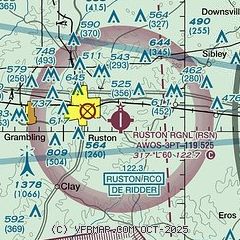
| Sectional chart |
|---|
|
| Airport distance calculator |
|---|
|
|
| Sunrise and sunset |
|---|
|
Times for 06-Jun-2026
| | Local
(UTC-5) | | Zulu
(UTC) |
|---|
| Morning civil twilight | | 05:36 | | 10:36 |
| Sunrise | | 06:04 | | 11:04 |
| Sunset | | 20:14 | | 01:14 |
| Evening civil twilight | | 20:42 | | 01:42 |
|
| Current date and time |
|---|
| Zulu (UTC) | 06-Jun-2026 23:34:40 |
|---|
| Local (UTC-5) | 06-Jun-2026 18:34:40 |
|---|
|
| METAR |
|---|
| KRSN | 062315Z AUTO 11010G17KT 10SM FEW022 BKN041 27/25 A2985 RMK AO2 T02690247 $
|
|
| TAF |
|---|
KMLU
28nm E | 062027Z 0620/0718 14006KT P6SM VCTS BKN035CB OVC090 TEMPO 0620/0624 VRB15G25KT 4SM -TSRA OVC035CB FM070500 17003KT P6SM BKN015 FM070900 19004KT P6SM OVC010 FM071200 17004KT P6SM OVC007
|
|
| NOTAMs |
|---|
NOTAMs are issued by the DoD/FAA and will open in a separate window not controlled by AirNav.
|
|

