FAA INFORMATION EFFECTIVE 14 MAY 2026
Location
| FAA Identifier: | MLU |
| Lat/Long: | 32-30-38.0010N 092-02-10.0810W
32-30.633350N 092-02.168017W
32.5105558,-92.0361336
(estimated) |
| Elevation: | 78.9 ft. / 24.0 m (surveyed) |
| Variation: | 03E (1995) |
| From city: | 3 miles E of MONROE, LA |
| Time zone: | UTC -5 (UTC -6 during Standard Time) |
| Zip code: | 71203 |
Airport Operations
| Airport use: | Open to the public |
| Activation date: | 04/1940 |
| Control tower: | yes |
| ARTCC: | FORT WORTH CENTER |
| FSS: | DE RIDDER FLIGHT SERVICE STATION |
| NOTAMs facility: | MLU (NOTAM-D service available) |
| Attendance: | CONTINUOUS |
| Wind indicator: | lighted |
| Segmented circle: | yes |
| Lights: | WHEN ATCT CLSD ACTVT MALSR RWYS 04 & 22; HIRL RWY 04/22; MIRL RWY 14/32; TWY LGTS - CTAF. PAPI RWYS 04, 22, 14 & 32 OPR CONSLY. |
| Beacon: | white-green (lighted land airport)
Operates sunset to sunrise. |
| Fire and rescue: | ARFF index B |
| Airline operations: | TWYS J & E EAST OF RWY 04/22 NOT AVBL FOR ACR OPNS WITH OVER 9 PSGR SEATS. |
Airport Communications
| CTAF: | 118.9 |
| UNICOM: | 122.95 |
| ATIS: | 125.05 |
| WX ASOS: | PHONE 318-327-5675 |
| MONROE GROUND: | 121.9 [0600-2200] |
| MONROE TOWER: | 118.9 257.8 [0600-2200] |
| MONROE APPROACH: | 118.15 ;WITHIN 20 NM BLW 4000 FT 126.9 290.475 ;WITHIN 20 NM BLW 4000 FT 307.9 [0600-2200] |
| MONROE DEPARTURE: | 118.15 ;WITHIN 20 NM BLW 4000 FT 126.9 290.475 ;WITHIN 20 NM BLW 4000 FT 307.9 [0600-2200] |
| CLEARANCE DELIVERY: | 121.65 |
| EMERG: | 121.5 243.0 |
| IC: | 118.15 ;WITHIN 20 NM BLW 4000 FT 290.475 ;WITHIN 20 NM BLW 4000 FT |
| TRSA: | 118.15 ;WITHIN 20 NM BLW 4000 FT 126.9 290.475 ;WITHIN 20 NM BLW 4000 FT 307.9 |
| WX AWOS-3PT at BQP (17 nm NE): | 118.375 (318-281-1443) |
- APCH/DEP CTL SVC PRVDD BY FORT WORTH ARTCC (ZFW) ON FREQS 126.325/346.25 (MONROE RCAG) WHEN MONROE APCH CTL (MLU) CLSD.
Nearby radio navigation aids
| VOR radial/distance | | VOR name | | Freq | | Var |
|---|
| MLU at field | | MONROE VORTAC | | 117.20 | | 03E |
| NDB name | | Hdg/Dist | | Freq | | Var | | ID |
|---|
| SABAR | | 043/4.8 | | 392 | | 03E | | ML | -- .-.. |
| BASTROP | | 205/16.6 | | 329 | | 03E | | BQP | -... --.- .--. |
Airport Services
| Fuel available: | 100LL JET-A |
| Parking: | hangars and tiedowns |
| Airframe service: | MAJOR |
| Powerplant service: | MAJOR |
| Bottled oxygen: | NONE |
| Bulk oxygen: | HIGH |
Runway Information
Runway 4/22
| Dimensions: | 7504 x 150 ft. / 2287 x 46 m |
| Surface: | asphalt/grooved, in good condition |
| Weight bearing capacity: | | Single wheel: | 75.0 | | Double wheel: | 170.0 | | Double tandem: | 290.0 |
|
| Runway edge lights: | high intensity |
| RUNWAY 4 | | RUNWAY 22 |
| Latitude: | 32-30.231195N | | 32-31.105710N |
| Longitude: | 092-02.738968W | | 092-01.705618W |
| Elevation: | 75.5 ft. | | 74.5 ft. |
| Traffic pattern: | left | | left |
| Runway heading: | 042 magnetic, 045 true | | 222 magnetic, 225 true |
| Declared distances: | TORA:7504 TODA:7504 ASDA:7504 LDA:7504 | | TORA:7504 TODA:7504 ASDA:7504 LDA:7504 |
| Markings: | precision, in good condition | | precision, in good condition |
| Visual slope indicator: | 4-light PAPI on left (3.00 degrees glide path) | | 4-light PAPI on left (3.00 degrees glide path) |
| RVR equipment: | touchdown | | rollout |
| Approach lights: | MALSR: 1,400 foot medium intensity approach lighting system with runway alignment indicator lights | | MALSR: 1,400 foot medium intensity approach lighting system with runway alignment indicator lights |
| Touchdown point: | yes, no lights | | yes, no lights |
| Instrument approach: | ILS | | ILS |
Runway 14/32
| Dimensions: | 6301 x 150 ft. / 1921 x 46 m |
| Surface: | asphalt, in good condition |
| Weight bearing capacity: | | Single wheel: | 75.0 | | Double wheel: | 170.0 | | Double tandem: | 290.0 |
|
| Runway edge lights: | medium intensity |
| RUNWAY 14 | | RUNWAY 32 |
| Latitude: | 32-30.989712N | | 32-30.193300N |
| Longitude: | 092-02.497238W | | 092-01.709507W |
| Elevation: | 78.4 ft. | | 73.4 ft. |
| Traffic pattern: | left | | left |
| Runway heading: | 137 magnetic, 140 true | | 317 magnetic, 320 true |
| Declared distances: | TORA:6301 TODA:6301 ASDA:6301 LDA:6301 | | TORA:6301 TODA:6301 ASDA:6301 LDA:6301 |
| Markings: | nonprecision, in good condition | | nonprecision, in good condition |
| Visual slope indicator: | 4-light PAPI on left (3.00 degrees glide path) | | 4-light PAPI on left (3.00 degrees glide path) |
| Runway end identifier lights: | yes | | yes |
| Touchdown point: | yes, no lights | | yes, no lights |
Airport Ownership and Management from official FAA records
| Ownership: | Publicly-owned |
| Owner: | CITY OF MONROE
PO BOX 123
MONROE, LA 71210
Phone 318-329-2200 |
| Manager: | CHARLES BUTCHER
5400 OPERATIONS RD
MONROE, LA 71203
Phone 318-329-2460 |
Additional Remarks
| A39-14/32 | PCR VALUE: 330/R/D/X/T |
| A39-04/22 | PCR VALUE: 1120/F/D/X/T |
| - | TWY E EAST OF RWY 04/22 RESTRICTED TO ACFT WITH WINGSPAN UNDER 90 FT. TWY C TURNAROUND BTN APCH END RWY 22 AND TWY C1 CLSD TO ACFT WINGSPAN MORE THAN 49 FT. TWY C2 CLSD. |
| - | BIRD ACT ON AND INVOF ARPT. |
| - | FOR CD WHEN ATCT IS CLSD CTC FORT WORTH ARTCC AT 817-858-7584 |
Instrument Procedures
NOTE: All procedures below are presented as PDF files. If you need a reader for these files, you should download the free Adobe Reader.NOT FOR NAVIGATION. Please procure official charts for flight.
FAA instrument procedures published for use from 14 May 2026 at 0901Z to 11 June 2026 at 0900Z.
IAPs - Instrument Approach Procedures |
|---|
| ILS OR LOC RWY 04 | |
download (270KB) |
| ILS OR LOC RWY 22 | |
download (275KB) |
| RNAV (GPS) RWY 04 | |
download (222KB) |
| RNAV (GPS) RWY 14 | |
download (217KB) |
| RNAV (GPS) RWY 22 | |
download (220KB) |
| RNAV (GPS) RWY 32 | |
download (232KB) |
| VOR/DME RWY 04 | |
download (219KB) |
| VOR RWY 22 | |
download (225KB) |
| VOR RWY 32 **CHANGED** | |
download (228KB) |
| Radar Approach Procedures available | |
download (184KB) |
| NOTE: Special Alternate Minimums apply | |
download (159KB) |
| NOTE: Special Take-Off Minimums/Departure Procedures apply | |
download (300KB) |
Other nearby airports with instrument procedures:
M79 - John H Hooks Jr Memorial Airport (13 nm E)
KBQP - Morehouse Memorial Airport (17 nm NE)
KRSN - Ruston Regional Airport (28 nm W)
F88 - Jonesboro Airport (40 nm SW)
KCRT - Z M Jack Stell Field Airport (41 nm N)
|
|

Road maps at:
MapQuest
Bing
Google
| Aerial photo |
|---|
WARNING: Photo may not be current or correct

Do you have a better or more recent aerial photo of Monroe Regional Airport that you would like to share? If so, please send us your photo.
|
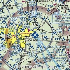
| Sectional chart |
|---|
|
 Download PDF
of official airport diagram from the FAA
| Airport distance calculator |
|---|
|
|
| Sunrise and sunset |
|---|
|
Times for 05-Jun-2026
| | Local
(UTC-5) | | Zulu
(UTC) |
|---|
| Morning civil twilight | | 05:33 | | 10:33 |
| Sunrise | | 06:02 | | 11:02 |
| Sunset | | 20:12 | | 01:12 |
| Evening civil twilight | | 20:40 | | 01:40 |
|
| Current date and time |
|---|
| Zulu (UTC) | 05-Jun-2026 17:44:10 |
|---|
| Local (UTC-5) | 05-Jun-2026 12:44:10 |
|---|
|
| METAR |
|---|
| KMLU | 051653Z 16003KT 10SM FEW031 29/20 A3003 RMK AO2 SLP168 T02940200
|
KBQP
17nm NE | 051730Z AUTO 00000KT 29/18 A3004 RMK AO2 T02870176 PWINO
|
|
| TAF |
|---|
| KMLU | 051146Z 0512/0612 17004KT P6SM BKN250 FM051800 12005KT P6SM SCT050 BKN250 FM060000 14003KT P6SM SCT040 SCT100 BKN250 FM060800 11003KT P6SM OVC012
|
|
| NOTAMs |
|---|
NOTAMs are issued by the DoD/FAA and will open in a separate window not controlled by AirNav.
|
|


