FAA INFORMATION EFFECTIVE 09 JULY 2026
Location
| FAA Identifier: | SBP |
| Lat/Long: | 35-14-14.1810N 120-38-33.3700W
35-14.236350N 120-38.556167W
35.2372725,-120.6426028
(estimated) |
| Elevation: | 212.3 ft. / 64.7 m (surveyed) |
| Variation: | 15E (1980) |
| From city: | 3 miles S of SAN LUIS OBISPO, CA |
| Time zone: | UTC -7 (UTC -8 during Standard Time) |
| Zip code: | 93401 |
Airport Operations
| Airport use: | Open to the public |
| Activation date: | 04/1940 |
| Control tower: | yes |
| ARTCC: | LOS ANGELES CENTER |
| FSS: | HAWTHORNE FLIGHT SERVICE STATION |
| NOTAMs facility: | SBP (NOTAM-D service available) |
| Attendance: | 0600-1700 |
| Pattern altitude: | TPA 991 AGL SINGLE ENG; 1491 AGL MULTI-ENG, JET & HIGH PER. |
| Wind indicator: | lighted |
| Segmented circle: | yes |
| Lights: | ACTVT MALSR RWY 11; REIL RWY 29; VASI RWY 11; HIRL RWY 11/29 - CTAF. VASI RWY 29 OPR CONSLY. |
| Beacon: | white-green (lighted land airport)
Operates sunset to sunrise. |
| Fire and rescue: | ARFF index B |
Airport Communications
| CTAF: | 124.0 |
| UNICOM: | 122.95 |
| ATIS: | 120.6 |
| WX ASOS: | 120.6 (805-547-1260) |
| SAN LUIS GROUND: | 121.6 [0600-2000] |
| SAN LUIS TOWER: | 124.0 379.9 [0600-2000] |
| SANTA BARBARA APPROACH: | 127.725 |
| SANTA BARBARA DEPARTURE: | 127.725 |
| WX AWOS-3 at L52 (8 nm S): | 118.375 (805-489-1305) |
- APCH/DEP CTL SVC PRVDD BY LOS ANGELES ARTCC (ZLA) ON FREQS 119.05/269.5 (SAN LUIS OBISPO RCAG) WHEN SANTA BARBARA APCH CTL (SBA) CLSD.
Nearby radio navigation aids
| VOR radial/distance | | VOR name | | Freq | | Var |
|---|
| MQOr083/5.8 | | MORRO BAY VORTAC | | 112.40 | | 16E |
| GLJr325/(18.1) | | GUADALUPE VOR | | 113.05 | | 16E |
| PRBr166/26.1 | | PASO ROBLES VORTAC | | 114.30 | | 16E |
| FLWr267/39.1 | | FELLOWS VOR/DME | | 117.50 | | 16E |
Airport Services
| Fuel available: | 100LL JET-A |
| Parking: | tiedowns |
| Airframe service: | MAJOR |
| Powerplant service: | MAJOR |
| Bottled oxygen: | HIGH/LOW
REFIL CUSTOMER BOTTLE. |
| Bulk oxygen: | HIGH |
Runway Information
Runway 11/29
| Dimensions: | 6101 x 150 ft. / 1860 x 46 m |
| Surface: | asphalt/grooved, in good condition |
| Weight bearing capacity: | | Single wheel: | 96.0 | | Double wheel: | 124.0 | | Double tandem: | 181.0 |
|
| Runway edge lights: | high intensity |
| Operational restrictions: | BLAST PAD DEP END RY 11: 600 FT X 200 FT. BLAST PAD DEP END RY 29: 600 FT X 200 FT. |
| RUNWAY 11 | | RUNWAY 29 |
| Latitude: | 35-14.532887N | | 35-13.959380N |
| Longitude: | 120-38.974020W | | 120-37.967193W |
| Elevation: | 161.8 ft. | | 212.2 ft. |
| Traffic pattern: | left | | left |
| Runway heading: | 110 magnetic, 125 true | | 290 magnetic, 305 true |
| Displaced threshold: | 800 ft. | | 501 ft. |
| Declared distances: | TORA:6100 TODA:6100 ASDA:6100 LDA:5300 | | TORA:6100 TODA:6100 ASDA:6100 LDA:5600 |
| Markings: | precision, in good condition | | nonprecision, in good condition |
| Visual slope indicator: | 4-box VASI on left (3.00 degrees glide path)
RWY 11 VASI UNUSBL BYD 5 DEGS RIGHT OF RWY CNTRLN. | | 4-box VASI on left (3.25 degrees glide path) |
| Approach lights: | MALSR: 1,400 foot medium intensity approach lighting system with runway alignment indicator lights | | |
| Runway end identifier lights: | no | | yes |
| Touchdown point: | yes, no lights | | yes, no lights |
| Instrument approach: | ILS | | |
Runway 7/25
| Dimensions: | 2500 x 100 ft. / 762 x 30 m |
| Surface: | asphalt, in good condition |
| Weight bearing capacity: | | Single wheel: | 24.0 | | Double wheel: | 38.0 |
|
| Operational restrictions: | RWY 07/25 NOT AVBL FOR PART 121/PART 380 OPS WITH SKED PAX CARRYING OPS MORE THAN 9 PAX SEATS AND NON-SKED PAX CARRYING OPS MORE THAN 30 PAX SEATS. |
| RUNWAY 7 | | RUNWAY 25 |
| Latitude: | 35-14.211645N | | 35-14.213218N |
| Longitude: | 120-39.016143W | | 120-38.513957W |
| Elevation: | 162.0 ft. | | 189.0 ft. |
| Traffic pattern: | left | | left |
| Runway heading: | 075 magnetic, 090 true | | 255 magnetic, 270 true |
| Declared distances: | TORA:2500 TODA:2500 ASDA:2500 LDA:2500 | | TORA:2500 TODA:2500 ASDA:2500 LDA:2500 |
| Markings: | basic, in good condition | | basic, in good condition |
| Runway end identifier lights: | no | | no |
| Touchdown point: | yes, no lights | | yes, no lights |
| Obstructions: | 10 ft. road, 410 ft. from runway, 21:1 slope to clear | | none |
Airport Ownership and Management from official FAA records
| Ownership: | Publicly-owned |
| Owner: | SAN LUIS OBISPO COUNTY
COUNTY GOVERNMENT CENTER
SAN LUIS OBISPO, CA 93408
Phone (805) 781-5205 |
| Manager: | COURTNEY JOHNSON
975 AIRPORT DRIVE, SUITE 1
SAN LUIS OBISPO, CA 93401
Phone 805-781-5218
DEPUTY DIR: TIM O'KEEFFE 805-788-2000. |
Additional Remarks
| A39-11/29 | PCR VALUE: 390/F/D/X/T |
| A39-07/25 | PCR VALUE: 90/F/D/X/T |
| E60-11 | ENGINEERED MATERIAL ARRESTING SYSTEM (EMAS) 300 FT IN LENGTH BY 170 FT IN WIDTH LCTD AT THE DER 11. |
| E60-29 | ENGINEERED MATERIAL ARRESTING SYSTEM (EMAS) 312 FT IN LENGTH BY 170 FT IN WIDTH LCTD AT THE DER 29. |
| - | RECURRING FLOCKS OF WATERFOWL ON AND IN VICINITY OF ARPT DURG WINTER MONTHS. |
| - | TWY A BTN TWYS C AND F WILL BE PDCLY RSTRD FOR ACFT WITH WINGSPAN OF 79 FT OR GTR DRG OPNS ON RWY 11/29. |
| - | TAXILANE WIDTHS LESS THAN STANDARD. |
| - | NOISE SENSITIVE ARPT; TCH 50 FT; FOR NOISE ABATEMENT INFO CTC AMGR (805) 781-5205. |
| - | RY 29 DESIGNATED CALM WIND RY. |
| - | ATCT UNABLE TO SEE ACFT IN HOLDING BAY AT NW END OF TWY A. MOVEMENT FM HOLDING BAY REQUIRES ATCT APVL DURG ATCT HRS. |
| - | TRANSIENT PARKING EXCEEDING 2 HRS CTC FBO EXCEPT FOR AIR CARRIERS. |
| - | PUSHBACK FM TRML GATES AT PILOT'S DISCRETION. DO NOT CALL GND CTL FOR PUSHBACK. |
| - | TWY A RUN-UP AREA FOR RWY 29, JETS USE MNM BREAKAWAY PWR. |
Instrument Procedures
NOTE: All procedures below are presented as PDF files. If you need a reader for these files, you should download the free Adobe Reader.NOT FOR NAVIGATION. Please procure official charts for flight.
FAA instrument procedures published for use from 09 July 2026 at 0901Z to 06 August 2026 at 0900Z.
IAPs - Instrument Approach Procedures |
|---|
| ILS OR LOC RWY 11 | |
download (386KB) |
| RNAV (GPS) RWY 11 **CHANGED** | |
download (350KB) |
| RNAV (GPS) RWY 29 **CHANGED** | |
download (422KB) |
| VOR OR TACAN-A **CHANGED** | |
download (332KB) |
| NOTE: Special Alternate Minimums apply | |
download (140KB) |
Departure Procedures |
|---|
| AVILA FOUR | |
download (202KB) |
| CREPE THREE | |
download (219KB) |
| WYNNR FOUR | |
download (184KB) |
| NOTE: Special Take-Off Minimums/Departure Procedures apply | |
download (347KB) |
Other nearby airports with instrument procedures:
KSMX - Santa Maria Public Airport/Capt G Allan Hancock Field (22 nm SE)
KPRB - Paso Robles Municipal Airport (26 nm N)
KVBG - Vandenberg Space Force Base (30 nm S)
KLPC - Lompoc Airport (35 nm S)
KIZA - Santa Ynez Airport/Kunkle Field (47 nm SE)
|
|

Road maps at:
MapQuest
Bing
Google
| Aerial photo |
|---|
WARNING: Photo may not be current or correct
 Photo by www.focalflight.com
Photo taken 18-Jun-2020
looking southeast.
Photo by www.focalflight.com
Photo taken 18-Jun-2020
looking southeast.
Do you have a better or more recent aerial photo of San Luis Obispo County Regional Airport that you would like to share? If so, please send us your photo.
|
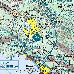
| Sectional chart |
|---|
|
CAUTION: Diagram may not be current
 Download PDF
of official airport diagram from the FAA
| Airport distance calculator |
|---|
|
|
| Sunrise and sunset |
|---|
|
Times for 13-Jul-2026
| | Local
(UTC-7) | | Zulu
(UTC) |
|---|
| Morning civil twilight | | 05:30 | | 12:30 |
| Sunrise | | 05:59 | | 12:59 |
| Sunset | | 20:17 | | 03:17 |
| Evening civil twilight | | 20:47 | | 03:47 |
|
| Current date and time |
|---|
| Zulu (UTC) | 13-Jul-2026 19:42:01 |
|---|
| Local (UTC-7) | 13-Jul-2026 12:42:01 |
|---|
|
| METAR |
|---|
| KSBP | 131856Z 25004KT 10SM CLR 27/13 A2997 RMK AO2 SLP145 T02720128
|
|
| TAF |
|---|
| KSBP | 131720Z 1318/1418 VRB03KT P6SM BKN250 FM132000 29008KT P6SM BKN250 FM140400 VRB03KT P6SM SCT250
|
|
| NOTAMs |
|---|
NOTAMs are issued by the DoD/FAA and will open in a separate window not controlled by AirNav.
|
|


