FAA INFORMATION EFFECTIVE 09 JULY 2026
Location
| FAA Identifier: | PRB |
| Lat/Long: | 35-40-22.4000N 120-37-37.5000W
35-40.373333N 120-37.625000W
35.6728889,-120.6270833
(estimated) |
| Elevation: | 838.7 ft. / 255.6 m (surveyed) |
| Variation: | 15E (1980) |
| From city: | 4 miles NE of PASO ROBLES, CA |
| Time zone: | UTC -7 (UTC -8 during Standard Time) |
| Zip code: | 93446 |
Airport Operations
| Airport use: | Open to the public |
| Activation date: | 10/1943 |
| Control tower: | no |
| ARTCC: | OAKLAND CENTER |
| FSS: | HAWTHORNE FLIGHT SERVICE STATION |
| NOTAMs facility: | PRB (NOTAM-D service available) |
| Attendance: | 0700-1800
FEE FOR CALL OUT SVC OTR HRS, 805-246-1443. |
| Wind indicator: | lighted |
| Segmented circle: | yes |
| Lights: | RY LGTS OPER DUSK-2200; AFTER 2200 ACTVT HIRL RY 01/19 MIRL RY 13/31 PAPI RYS 19 & 31, RY H1 PERIMETER LGTS - CTAF. |
| Beacon: | white-green (lighted land airport)
Operates sunset to sunrise. |
Airport Communications
| CTAF/UNICOM: | 123.0 |
| WX ASOS: | 120.125 (805-721-3168) |
- COMMUNICATIONS PRVDD BY HAWTHORNE RADIO ON FREQS 122.4 (PASO ROBLES RCO).
- APCH/DEP CTL SVC PRVDD BY OAKLAND ARTCC (ZOA) ON FREQS 128.7/307.0 (PRIEST RCAG).
Nearby radio navigation aids
| VOR radial/distance | | VOR name | | Freq | | Var |
|---|
| PRB at field | | PASO ROBLES VORTAC | | 114.30 | | 16E |
| MQOr358/26.1 | | MORRO BAY VORTAC | | 112.40 | | 16E |
| AVEr257/31.7 | | AVENAL VOR/DME | | 117.10 | | 16E |
| NDB name | | Hdg/Dist | | Freq | | Var | | ID |
|---|
| HUNTER LIGGETT | | 107/32.4 | | 209 | | 15E | | HGT | .... --. - |
Airport Services
| Fuel available: | 100LL JET-A |
| Parking: | tiedowns |
| Airframe service: | MAJOR |
| Powerplant service: | MINOR |
| Bottled oxygen: | LOW |
Runway Information
Runway 1/19
| Dimensions: | 6008 x 150 ft. / 1831 x 46 m |
| Surface: | asphalt/grooved, in good condition |
| Weight bearing capacity: | | Single wheel: | 60.0 | | Double wheel: | 106.0 | | Double tandem: | 150.0 |
|
| Runway edge lights: | high intensity |
| RUNWAY 1 | | RUNWAY 19 |
| Latitude: | 35-39.966505N | | 35-40.835537N |
| Longitude: | 120-38.134630W | | 120-37.552758W |
| Elevation: | 814.5 ft. | | 803.4 ft. |
| Traffic pattern: | left | | left |
| Runway heading: | 014 magnetic, 029 true | | 194 magnetic, 209 true |
| Markings: | nonprecision, in good condition | | nonprecision, in good condition |
| Visual slope indicator: | | | 4-light PAPI on left (3.00 degrees glide path) |
| Runway end identifier lights: | no | | yes |
| Touchdown point: | yes, no lights | | yes, no lights |
Runway 13/31
| Dimensions: | 4701 x 100 ft. / 1433 x 30 m |
| Surface: | asphalt, in good condition |
| Weight bearing capacity: | | Single wheel: | 30.0 | | Double wheel: | 50.0 | | Double tandem: | 90.0 |
|
| Runway edge lights: | medium intensity |
| RUNWAY 13 | | RUNWAY 31 |
| Latitude: | 35-40.649245N | | 35-40.025252N |
| Longitude: | 120-37.625793W | | 120-37.062968W |
| Elevation: | 810.0 ft. | | 838.7 ft. |
| Traffic pattern: | left | | left |
| Runway heading: | 129 magnetic, 144 true | | 309 magnetic, 324 true |
| Markings: | nonprecision, in good condition | | nonprecision, in good condition |
| Visual slope indicator: | | | 4-light PAPI on left (3.00 degrees glide path) |
| Runway end identifier lights: | no | | no |
| Touchdown point: | yes, no lights | | yes, no lights |
| Obstructions: | none | | 54 ft. tree, 1950 ft. from runway, 32:1 slope to clear |
Helipad H1
| Dimensions: | 100 x 100 ft. / 30 x 30 m |
| Surface: | asphalt, in excellent condition |
| Runway edge lights: | PERI |
| Runway edge markings: | STANDARD HELIPAD MARKINGS. |
| Latitude: | 35-40.281000N | | |
| Longitude: | 120-38.160333W | | |
| Elevation: | 809.0 ft. | | |
| Traffic pattern: | left | | left |
| Markings: | , in good condition | | |
Airport Ownership and Management from official FAA records
| Ownership: | Publicly-owned |
| Owner: | CITY OF PASO ROBLES
1000 SPRING ST.
PASO ROBLES, CA 93446
Phone 805-237-3861 |
| Manager: | MARK W. SCANDALIS
4912 WING WAY
PASO ROBLES, CA 93446
Phone 805-237-3877 |
Additional Remarks
| A111 | MSCANDALIS@PRCITY.COM |
| - | PPR FOR AIRCRAFT OVER 80,000 LBS. CONTACT AMGR 805-237-3877 |
| - | RWY 19 DSGND CALM WIND RWY. |
| - | FOR CD IF UNA TO CTC ON FSS FREQ, CTC OAKLAND ARTCC AT 510-745-3380. |
| - | V22 OSPREY ARPT OPS RSTRD TO BTN 0700 TO 1530 LOCAL. |
| - | V22 OSPREY OPS PPR RQRD. |
Instrument Procedures
NOTE: All procedures below are presented as PDF files. If you need a reader for these files, you should download the free Adobe Reader.NOT FOR NAVIGATION. Please procure official charts for flight.
FAA instrument procedures published for use from 09 July 2026 at 0901Z to 06 August 2026 at 0900Z.
IAPs - Instrument Approach Procedures |
|---|
| RNAV (GPS) RWY 19 | |
download (261KB) |
| RNAV (GPS) RWY 31 | |
download (227KB) |
| VOR RWY 19 | |
download (216KB) |
| VOR-B | |
download (200KB) |
| NOTE: Special Alternate Minimums apply | |
download (121KB) |
Departure Procedures |
|---|
| BRALY ONE | |
download (212KB) |
| JEDGI TWO | |
download (216KB) |
|
|---|
| PASO ROBLES TWO (OBSTACLE) | |
download (393KB) |
| NOTE: Special Take-Off Minimums/Departure Procedures apply | |
download (354KB) |
Other nearby airports with instrument procedures:
KSBP - San Luis Obispo County Regional Airport (26 nm S)
C80 - New Coalinga Municipal Airport (34 nm NE)
KHGT - Tusi Army Heliport (Hunter Liggett) (35 nm NW)
KKIC - Mesa Del Rey Airport (41 nm NW)
KSMX - Santa Maria Public Airport/Capt G Allan Hancock Field (47 nm S)
|
|

Road maps at:
MapQuest
Bing
Google
| Aerial photo |
|---|
WARNING: Photo may not be current or correct
 Photo by www.focalflight.com
Photo taken 18-Jun-2020
looking southeast.
Photo by www.focalflight.com
Photo taken 18-Jun-2020
looking southeast.
Do you have a better or more recent aerial photo of Paso Robles Municipal Airport that you would like to share? If so, please send us your photo.
|
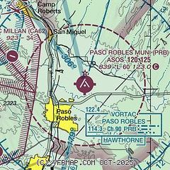
| Sectional chart |
|---|
|
| Airport distance calculator |
|---|
|
|
| Sunrise and sunset |
|---|
|
Times for 27-Jul-2026
| | Local
(UTC-7) | | Zulu
(UTC) |
|---|
| Morning civil twilight | | 05:39 | | 12:39 |
| Sunrise | | 06:08 | | 13:08 |
| Sunset | | 20:10 | | 03:10 |
| Evening civil twilight | | 20:39 | | 03:39 |
|
| Current date and time |
|---|
| Zulu (UTC) | 27-Jul-2026 20:11:56 |
|---|
| Local (UTC-7) | 27-Jul-2026 13:11:56 |
|---|
|
| METAR |
|---|
| KPRB | 271953Z AUTO 31006KT 10SM CLR 32/05 A3001 RMK AO2 SLP156 T03170050
|
|
| TAF |
|---|
| KPRB | 271720Z 2718/2818 31008KT P6SM SKC FM280100 30015G22KT P6SM SKC FM280700 31010KT P6SM SKC FM281100 VRB03KT P6SM SKC
|
|
| NOTAMs |
|---|
NOTAMs are issued by the DoD/FAA and will open in a separate window not controlled by AirNav.
|
|


