FAA INFORMATION EFFECTIVE 16 APRIL 2026
Location
| FAA Identifier: | SUU |
| Lat/Long: | 38-15-52.3320N 121-55-26.8733W
38-15.872200N 121-55.447888W
38.2645367,-121.9241315
(estimated) |
| Elevation: | 63.4 ft. / 19.3 m (surveyed) |
| Variation: | 13E (2020) |
| From city: | 3 miles E of FAIRFIELD, CA |
| Time zone: | UTC -7 (UTC -8 during Standard Time) |
| Zip code: | 94535 |
Airport Operations
| Airport use: | Private use. Permission required prior to landing |
| Activation date: | 05/1941 |
| Control tower: | yes |
| ARTCC: | OAKLAND CENTER |
| FSS: | RANCHO MURIETA FLIGHT SERVICE STATION |
| NOTAMs facility: | SUU (NOTAM-D service available) |
| Attendance: | CONTINUOUS |
| Segmented circle: | no |
| Beacon: | white-green (lighted land airport)
Operates sunset to sunrise. |
| International operations: | customs landing rights airport |
Airport Communications
| TRAVIS GROUND: | 121.8 289.4 |
| TRAVIS TOWER: | 120.75 254.4 239.05 |
| TRAVIS APPROACH: | 119.9 ;SOUTH 126.6 ;NORTH 281.45 ;NORTH 322.325 ;SOUTH 128.4 139.9 398.2 |
| TRAVIS DEPARTURE: | 119.9 281.45 ;NORTH 306.9 ;NORTH 322.325 ;SOUTH 126.6 |
| CLEARANCE DELIVERY: | 127.55 335.8 |
| BMBER STAR: | 119.9 ;SOUTH 126.6 ;NORTH 306.9 ;NORTH 322.325 ;SOUTH 124.8 |
| COMD POST: | 141.9 349.4 |
| D-ATIS: | 135.55 292.125 |
| EMERG: | 121.5 243.0 |
| PALISADES STAR: | 123.7 |
| PMSV METRO: | 271.1 |
| PTD: | 342.5 |
| WX ASOS at VCB (7 nm N): | 134.75 (707-240-8032) |
| WX AWOS-AV at O88 (11 nm E): | 127.075 (707-374-5396) |
| WX ASOS at APC (17 nm W): | PHONE 707-252-7916 |
| WX AWOS-3 at EDU (17 nm N): | 119.025 (530-754-6839) |
| WX ASOS at CCR (18 nm S): | PHONE 925-689-2077 |
| WX AWOS-3P at DWA (19 nm N): | 125.775 (530-750-2759) |
- COMMUNICATIONS: SFA REMARKS: ON REQ.
- ILS/RADAR-RADAR: LIMITATION BETWEEN TACAN (SUU) 075 AND 185 RADIALS, BEGINNING 3 DME OUT TO 13 DME ALL ALTITUDES. TRAFFIC ADVISORIES AVAILABLE ON TRANSPONDER EQUIPPED AIRCRAFT ONLY.
- WX SVC AVBL 24/7 AT DSN 837-3003/5549, C707-424-3003/5549. AN/FMQ-19 AUTOMATED OBSERVING SYS IN USE; AUGMENTED BY HUMAN OBSN WHEN NEC. DUR WX FLT CLOSURE OR EVAC, REMOTE BRIEFING SVC AVBL FR 25 OP WX SQ DSN 228-6598/6599/6588, C520-228-6598/6599/6588. WHEN AUTO OBSN SYS INOP, OBST AT 350-020 DEGS AND 210-280 DEGS MAY IMPACT DERIVED PREVAILING VIS. RVR INFO NOT AVBL RWY 21R APCH.
- COMMUNICATIONS: TRAVIS AERO CLUB - 122.725 REMARKS: LCTD AT RIO VISTA MUNI O88.
- CALL GOLDEN OPS
- COMM/NAV/WEATHER REMARKS: ASR-11/DASR - NO-NOTAM MP 0701-1300Z++ MON THRU FRI. ILS/RADAR-RADAR: RADAR COVERAGE LTD IN AREA BOUNDED BY SUU075/004, SUU115/013, SUU157/011, SUU185/003. TFC ADZY MAY NOT BE AVBL TO NON-TRANSPONDER EQPT ACFT.
Nearby radio navigation aids
| VOR radial/distance | | VOR name | | Freq | | Var |
|---|
| CCRr006/14.4 | | CONCORD VOR/DME | | 117.00 | | 17E |
| SACr221/20.6 | | SACRAMENTO VORTAC | | 115.20 | | 17E |
| SGDr059/21.8 | | SCAGGS ISLAND VORTAC | | 112.10 | | 17E |
| MCCr208/34.4 | | MC CLELLAN VOR/DME | | 109.20 | | 17E |
| OAKr007/35.3 | | OAKLAND VOR/DME | | 116.80 | | 17E |
| SAUr032/37.5 | | SAUSALITO VOR/DME | | 116.20 | | 17E |
Airport Services
| Fuel available: | A++ |
| Parking: | hangars |
| Airframe service: | MAJOR |
| Powerplant service: | MAJOR |
| Bottled oxygen: | NONE |
| Bulk oxygen: | HIGH/LOW |
Runway Information
Runway 3R/21L
| Dimensions: | 10995 x 150 ft. / 3351 x 46 m |
| Surface: | concrete |
| Weight bearing capacity: | |
| Runway edge lights: | high intensity |
| RUNWAY 3R | | RUNWAY 21L |
| Latitude: | 38-15.688000N | | 38-16.907500N |
| Longitude: | 121-55.591000W | | 121-53.892000W |
| Elevation: | 53.2 ft. | | 53.3 ft. |
| Traffic pattern: | left | | left |
| Runway heading: | 034 magnetic, 047 true | | 214 magnetic, 227 true |
| Markings: | precision, in good condition | | precision, in good condition |
| Visual slope indicator: | 4-light PAPI on left (2.50 degrees glide path) | | 4-light PAPI on left (2.80 degrees glide path) |
| RVR equipment: | touchdown, midfield, rollout | | touchdown, midfield, rollout |
| Approach lights: | | | ALSF2: standard 2,400 foot high intensity approach lighting system with centerline sequenced flashers (category II or III) |
| Runway end identifier lights: | no | | no |
| Centerline lights: | yes | | yes |
| Touchdown point: | yes, no lights | | yes, lighted |
| Instrument approach: | | | ILS |
Runway 32/212
| Dimensions: | 3500 x 90 ft. / 1067 x 27 m |
| Surface: | concrete |
| Weight bearing capacity: | |
| RUNWAY 32 | | RUNWAY 212 |
| Latitude: | 38-16.428833N | | 38-16.817000N |
| Longitude: | 121-54.413167W | | 121-53.872167W |
| Elevation: | 57.4 ft. | | 51.6 ft. |
| Traffic pattern: | left | | left |
Runway 3L/21R
| Dimensions: | 11001 x 300 ft. / 3353 x 91 m |
| Surface: | PEM |
| Weight bearing capacity: | |
| Runway edge lights: | high intensity |
| RUNWAY 3L | | RUNWAY 21R |
| Latitude: | 38-14.597833N | | 38-15.818500N |
| Longitude: | 121-57.418667W | | 121-55.719667W |
| Elevation: | 32.7 ft. | | 50.4 ft. |
| Traffic pattern: | left | | left |
| Runway heading: | 034 magnetic, 047 true | | 214 magnetic, 227 true |
| Markings: | precision, in good condition | | precision, in good condition |
| Visual slope indicator: | 4-light PAPI on left (2.50 degrees glide path) | | 4-light PAPI on left (2.80 degrees glide path) |
| RVR equipment: | touchdown | | rollout |
| Runway end identifier lights: | no | | no |
| Touchdown point: | yes, no lights | | yes, no lights |
| Instrument approach: | LOC/GS | | LOC/GS |
Airport Ownership and Management from official FAA records
| Ownership: | U.S. Air Force |
| Owner: | USAF
TRAVIS AFB
FAIRFIELD, CA 94535 |
| Manager: | BASE OPERATIONS (USAF)
TRAVIS AFB
FAIRFIELD, CA 94535
Phone 707-424-2836 |
Additional Remarks
| - | CAUTION: RWY EDGE LGTS FOR BOTH RWYS LCTD MORE THAN 10 FT FROM EDGE OF USABLE RWY SFC. |
| - | CAUTION: EXTV LGT ACFT OPR. POSSIBLE RF INTFC ALL FREQS 9 NM NE OVER VOA TRANS. EXP WIND SHEAR BLW 2000 FT ON APCH TO ALL RWYS. HVY C5 JET TFC IN IMMED VCNTY. HI DENSITY VFR TFC CROS FINAL APCH AND DEP CRS. |
| - | CAUTION: ARR ACFT EXP HVY JET ACFT CROS RWY TO PARL TWY. |
| - | MISC: ALL ACFT CARRYING DV WILL NOTIFY COMD POST NO LATER THAN 24 HR PRIOR WITH ARR TIME AND RQR AT DSN 837-5517 OR C707-424-5517. ACFT WITH DV CODE 7 OR ABV AND ALL INBD PAX/CARGO ACFT MUST CTC COMD POST 30 MIN PRIOR TO LDG AND CONFIRM BLOCK TIME. |
| - | MISC: FIRST 2175 FT RWY 03R AND FIRST 1000 FT RWY 21L CONC; 75 FT KEEL SECTION IS CONC, RMNG WIDTH IS REINFORCED ASPH, 38 FT ON EITHER SIDE OF KEEL. FIRST 1000 FT RWY 21R AND FIRST 2900 FT RWY 03L CONC, MID 7100 FT ASPH. |
| - | RWY-LGTS: RWY 21L SF. |
| - | TFC PAT REVISE TO: RECTANGULAR 1600 FT, OVERHEAD 2100 FT. |
| - | CAUTION: TWY N MAY BE TMPRY CLSD WO NTC S OF 900 RAMP DUE TO C17 COMBAT OFF-LOAD/STAR TRNG. |
| - | RSTD: OUTBOARD ENGS OF 4-ENG ACFT RSTRD TO IDLE PWR ON TWYS A, B, D, H, M, N, & T AND DRG TAXI OPS ON RWY 03R/21L. |
| - | CAUTION: NO C17 COMBAT OFFLOADS AUTHORIZED ON TWY DELTA EAST OF RWY 21L/3R. |
| - | MISC: BACKING OPS PROH ON SPOTS 511 THRU 515. SHOULDERS ARE NON-LOAD SFCS. RWY 21L/03R GROOVED 148 FT ENTIRE RY. |
| - | CAUTION: RWY 03R/21L EDGE LGTS HAVE GAPS OF MORE THAN 400 FT ON THE APCH/DEP END OF THE RWY. |
| - | CAUTION: BA ON RWY 03R/21L MAY BE IMPAIRED DUE TO HVY RUBBER DEPOSITS. |
| - | CSTMS/AG/IMG - DUE TO LTD. CSTMS, PN/COORD RQR FOR ARR OUTSIDE NML WKD HR. FOR NGT, SAT, SUN AND HOL ARR, 1 HR PN RQR. MSN COORD THRU TRAVIS COMD POST AT DSN 837-5517 OR C707-424-5517. |
| - | RWY: RWY 21L/03R GROOVED 148 FT ENTIRE RWY. RWY 21R FIRST 1000 FT CONC NOT GROOVED. |
| - | PPR DSN 837-2836/2837 C707-424-2836/2837. |
| - | JASU - 1(MA-1) 6(MA-1A) 1(MC-1A) 1(MC-2A) 8(A/M32A-86) 1(707 STARTING UNIT). |
| - | MISC: TRAVIS CRASH FIRE RESPONSE STEADY STATE ARFF AGENT QNTY IS 9000 GALLONS, AND STEADY STATE PSNL AVBLTY IS 16. ARFF CONDS FOR TRAVIS AFB ARE REDUCED LEVEL OF SERVICE (RLS) FOR NFPA, ICAO, AND USAF CATS 7-9, AND CRITICAL LEVEL OF SERVICE (CLS) FOR NFPA, ICAO, AND USAF CAT 10. |
| - | MISC: DAVID GRANT MEDICAL CENTER HELIPAD LCTD 3816.12N/12158.12W, ELEV 59 FT. HELIPAD NOT VISIBLE FROM TWR. HELIPAD EQUIPPED WITH PILOT CTL LGT (VHF 120.75) LDG/DEP WILL BE AT YOUR OWN RISK. |
| - | MISC: 900 RAMP B747 AND C5 ACFT ON SPOT 902 WILL OFFSET 5 FT NW OF EXISTING TAXI LINE DUE TO WINGTIP CLNC. |
| - | MISC: CTC AFLD MGMT FOR CUR BIRD WATCH COND. SEE AP1 FOR FURTHER INFO. |
| - | CAUTION: POTENTIAL FOR UAS OPS IN VCNTY OF TRAVIS AFB. |
| - | MISC: AIRCREW AND PAX TRNSPN LTD TO INITIAL PICKUP, FINAL DROP-OFF, AND MSN PLANNING AT BASE OPS. ALL OTR GND TRNSPN REQS WILL BE MET BASED ON MSN PRIORITY. FAILURE TO COMPLY MAY RESULT IN LOSS OF TRNSPN SUPPORT. |
| - | MISC: TWY A SFC PAINT INCOR; SHOULD READ 21L. |
| - | AMC SKEDD MSN (EXC FOR CIV DOD CONTR, DV, AND MEDEVAC MSN) DO NOT RQR PPR. ALL OTHER TSNT ACFT RQR PPR. TSNT ACFT REQ PPR CTC AFLD MGMT AT DSN 837-2836, C707-424-2836 OR 60OSS.OSAA.AMOPS@US.AF.MIL. ACFT WITH PPR CARRYING DV, AIR EVAC, AND SPL AIR MSN MUST CTC AFLD MGMT ON PTD FOR NOTIFICATION AND TRKG PURPOSES. |
| - | OIL - O-128-133-148-156. |
| - | RSTD: AIRCREW SHOULD REQ 15 MIN EARLY ENG START FOR RQRD BACK TAXI OPS. ANTICIPATE BACK TAXI ON RWY 03R-21L WITH POTENTIAL USE OF LZ FOR TAXIING WHEN DEP RWY 21L. |
| - | RSTD: 180 DEG TURN RSTD TO END OF RWY/THLD AREAS. |
| - | CAUTION: EMERG ACFT LDG RWY 03R EXP POSS DLA RESP EXCEEDING 1 MIN FOR INITIAL RESP AND 30 SEC FLW-ON RQMNTS FOR FIRE SUPPRESSION SVC. |
| - | MISC: NO CLASSIFIED MTRL STORAGE AVBL AT AM OPS. ALL TSNT CLASSIFIED MUST BE STORED IN TRAVIS AFB COMMAND POST. |
| - | RSTD: RWY 03L-21R CLSD. ALL AIR OPS PROHIBITED INCL APCH, LOW APCH, AND CIRCLING OR SIDESTEP REQ. |
| - | TRAN ALERT - SVC 24 HR DLY. EXP EXTV SVC DELAY WKEND AND HOL. TRAN ACFT, EXC AMC MSN, CTC COMD POST NOT LATER THAN 15 MIN OUT FOR SVC REQ. FLEET SVC AVBL. |
| - | REMARKS: HVY CONCENTRATION OF BLACKBIRDS, GULLS, AND OTR MIGRATORY BIRDS IN THE APCH AND DEP RTES AND ALG INFIELD AREAS FROM 1 OCT-30 NOV AND FROM 1 FEB-30 APR (PHASE II). |
Instrument Procedures
NOTE: All procedures below are presented as PDF files. If you need a reader for these files, you should download the free Adobe Reader.NOT FOR NAVIGATION. Please procure official charts for flight.
FAA instrument procedures published for use from 16 April 2026 at 0901Z to 14 May 2026 at 0900Z.
STARs - Standard Terminal Arrivals |
|---|
| BMBER ONE (RNAV) | |
2 pages:
[1] [2] (335KB) |
| OSVEE TWO (RNAV) | |
download (201KB) |
| PALISADES ONE | |
download (233KB) |
| PEBLL TWO (RNAV) | |
download (176KB) |
| SEATO FOUR | |
download (185KB) |
| SUTHU TWO (RNAV) | |
download (198KB) |
| WEBGO TWO (RNAV) | |
download (220KB) |
IAPs - Instrument Approach Procedures |
|---|
| ILS OR LOC OR RNAV (GPS) RWY 21L **CHANGED** | |
download (163KB) |
| ILS RWY 21L (CAT II) **CHANGED** | |
download (140KB) |
| RNAV (GPS) RWY 03R | |
download (75KB) |
| TACAN RWY 21L **CHANGED** | |
download (144KB) |
Departure Procedures |
|---|
| BESSA TWO (RNAV) | |
download (101KB) |
| REJOY ONE (RNAV) | |
download (89KB) |
| NOTE: Special Take-Off Minimums/Departure Procedures apply | |
download (364KB) |
Other nearby airports with instrument procedures:
KVCB - Nut Tree Airport (7 nm N)
O88 - Rio Vista Municipal Airport (11 nm E)
KAPC - Napa County Airport (17 nm W)
KEDU - University Airport (17 nm N)
KCCR - Buchanan Field Airport (18 nm S)
KDWA - Yolo County Airport (19 nm N)
|
|

Road maps at:
MapQuest
Bing
Google
| Aerial photo |
|---|
WARNING: Photo may not be current or correct

Do you have a better or more recent aerial photo of Travis Air Force Base that you would like to share? If so, please send us your photo.
|
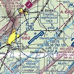
| Sectional chart |
|---|
|
 Download PDF
of official airport diagram from the FAA
| Airport distance calculator |
|---|
|
|
| Sunrise and sunset |
|---|
|
Times for 02-May-2026
| | Local
(UTC-7) | | Zulu
(UTC) |
|---|
| Morning civil twilight | | 05:42 | | 12:42 |
| Sunrise | | 06:11 | | 13:11 |
| Sunset | | 19:59 | | 02:59 |
| Evening civil twilight | | 20:27 | | 03:27 |
|
| Current date and time |
|---|
| Zulu (UTC) | 02-May-2026 19:44:18 |
|---|
| Local (UTC-7) | 02-May-2026 12:44:18 |
|---|
|
| METAR |
|---|
| KSUU | 021855Z AUTO 24019KT 10SM SCT016 SCT120 SCT150 BKN200 17/11 A2989 RMK AO2 PK WND 25028/52 SLP128 T01730109 $
|
KVCB
7nm N | 021853Z AUTO 20010G21KT 10SM CLR 17/11 A2989 RMK AO2 PK WND 22026/1815 SLP121 T01720111
|
KCCR
17nm S | 021853Z 22014G23KT 10SM OVC016 16/10 A2994 RMK AO2 SLP125 T01560100
|
KEDU
17nm N | 021935Z AUTO 20010KT 10SM 18/12 A2990 RMK AO1
|
KAPC
17nm W | 021854Z 18009KT 10SM OVC015 16/11 A2994 RMK AO2 SLP128 T01560111
|
KDWA
19nm N | 021935Z AUTO 16007KT 9SM CLR 20/12 A2989 RMK AO2
|
|
| TAF |
|---|
| KSUU | 021445Z 0214/0317 23015G25KT 9999 SCT010 SCT200 QNH2979INS BECMG 0301/0302 23012G18KT 9999 BKN010 OVC200 QNH2980INS TX21/0223Z TN13/0214Z
|
KAPC
17nm W | 021721Z 0218/0318 24007KT P6SM SCT012 BKN018 FM021930 23012KT P6SM FEW025 BKN200 FM030600 25006KT P6SM OVC013
|
|
| NOTAMs |
|---|
NOTAMs are issued by the DoD/FAA and will open in a separate window not controlled by AirNav.
|
|


