FAA INFORMATION EFFECTIVE 09 JULY 2026
Location
| FAA Identifier: | SVC |
| Lat/Long: | 32-38-11.5690N 108-09-22.9860W
32-38.192817N 108-09.383100W
32.6365469,-108.1563850
(estimated) |
| Elevation: | 5445.6 ft. / 1659.8 m (surveyed) |
| Variation: | 08E (2025) |
| From city: | 10 miles SE of SILVER CITY, NM |
| Time zone: | UTC -6 (UTC -7 during Standard Time) |
| Zip code: | 88043 |
Airport Operations
| Airport use: | Open to the public |
| Activation date: | 07/1942 |
| Control tower: | no |
| ARTCC: | ALBUQUERQUE CENTER |
| FSS: | ALBUQUERQUE FLIGHT SERVICE STATION |
| NOTAMs facility: | SVC (NOTAM-D service available) |
| Attendance: | 0600-1700 |
| Wind indicator: | lighted |
| Segmented circle: | yes |
| Lights: | ACTVT MALS RWY 26; REIL RWY 08; MIRL RWY 08/26 - CTAF. |
| Beacon: | white-green (lighted land airport)
Operates sunset to sunrise. |
| Fire and rescue: | ARFF index A |
Airport Communications
| CTAF/UNICOM: | 122.8 |
| WX AWOS-3: | 126.725 (575-388-5947) |
- APCH/DEP SVC PRVDD BY ALBUQUERQUE ARTCC (ABQ) ON FREQS 134.45/327.15 (ANIMAS RCAG).
Nearby radio navigation aids
| VOR radial/distance | | VOR name | | Freq | | Var |
|---|
| SVC at field | | SILVER CITY VOR/DME | | 115.75 | | 13E |
| DMNr296/35.3 | | DEMING VORTAC | | 108.60 | | 12E |
Airport Services
| Fuel available: | 100LL JET-A1 |
| Parking: | tiedowns |
Runway Information
Runway 8/26
| Dimensions: | 6803 x 100 ft. / 2074 x 30 m |
| Surface: | asphalt/grooved, in good condition |
| Weight bearing capacity: | | Single wheel: | 75.0 | | Double wheel: | 100.0 |
|
| Runway edge lights: | medium intensity |
| RUNWAY 8 | | RUNWAY 26 |
| Latitude: | 32-37.945513N | | 32-37.941262N |
| Longitude: | 108-09.915895W | | 108-08.590500W |
| Elevation: | 5386.2 ft. | | 5376.5 ft. |
| Traffic pattern: | left | | left |
| Runway heading: | 082 magnetic, 090 true | | 262 magnetic, 270 true |
| Markings: | nonprecision, in good condition | | nonprecision, in good condition |
| Visual slope indicator: | 4-light PAPI on left (3.00 degrees glide path) | | 4-light PAPI on left (3.00 degrees glide path) |
| Approach lights: | | | MALS: 1,400 foot medium intensity approach lighting system |
| Runway end identifier lights: | yes
39 INCHES TALL LOCTD 9 FT FM THE EDGE OF TWY A5. | | |
| Touchdown point: | yes, no lights | | yes, no lights |
| Instrument approach: | | | LOC/DME |
Runway 17/35
| Dimensions: | 5473 x 75 ft. / 1668 x 23 m |
| Surface: | dirt, in good condition |
| Operational restrictions: | DALGT VFR COND ONLY. |
| RUNWAY 17 | | RUNWAY 35 |
| Latitude: | 32-38.871267N | | 32-37.968983N |
| Longitude: | 108-09.506333W | | 108-09.514667W |
| Elevation: | 5445.6 ft. | | 5385.8 ft. |
| Traffic pattern: | left | | left |
| Runway heading: | 172 magnetic, 180 true | | 352 magnetic, 360 true |
| Displaced threshold: | 109 ft.
DTHR MKD BY TIRES. | | no |
| Obstructions: | 6 ft. fence
APCH RATIO 16:1 FM DTHR. | | 35 ft. pline, marked, 1000 ft. from runway, 28:1 slope to clear |
Runway 12/30
| Dimensions: | 4675 x 75 ft. / 1425 x 23 m |
| Surface: | dirt, in good condition |
| Operational restrictions: | DALGT VFR COND ONLY. |
| RUNWAY 12 | | RUNWAY 30 |
| Latitude: | 32-38.516700N | | 32-37.972050N |
| Longitude: | 108-09.640717W | | 108-08.996067W |
| Elevation: | 5424.8 ft. | | 5374.8 ft. |
| Traffic pattern: | left | | left |
| Runway heading: | 127 magnetic, 135 true | | 307 magnetic, 315 true |
| Obstructions: | 5 ft. fence, 100 ft. from runway, 20:1 slope to clear | | 30 ft. tower, lighted, 800 ft. from runway, 100 ft. right of centerline, 26:1 slope to clear |
Runway 3/21
| Dimensions: | 4537 x 80 ft. / 1383 x 24 m |
| Surface: | dirt, in fair condition |
| Operational restrictions: | DALGT VFR COND ONLY. |
| RUNWAY 3 | | RUNWAY 21 |
| Latitude: | 32-37.976200N | | 32-38.502583N |
| Longitude: | 108-09.804983W | | 108-09.176800W |
| Elevation: | 5382.8 ft. | | 5410.8 ft. |
| Traffic pattern: | left | | left |
| Runway heading: | 037 magnetic, 045 true | | 217 magnetic, 225 true |
| Obstructions: | 35 ft. pole, 800 ft. from runway, 250 ft. right of centerline, 22:1 slope to clear | | 4 ft. fence |
Airport Ownership and Management from official FAA records
| Ownership: | Publicly-owned |
| Owner: | GRANT COUNTY
P.O. BOX 6, 182 AIRPORT RD.
HURLEY, NM 88043
Phone 575-313-9784 |
| Manager: | REBEKAH WENGER
PO BOX 6 182 AIRPORT ROAD
HURLEY, NM 88043
Phone 575-313-9784 |
Additional Remarks
| A39-08/26 | PCR VALUE: 230/F/C/X/T |
| - | 5621 FT CRANE NE OF ARPT 8800 FT FM RWY 26 ON CNTRLN. |
| - | FOR CD IF UNA TO CTC ON FSS FREQ, CTC ALBUQUERQUE ARTCC AT 505-856-4561. |
| - | TWY A2, A3 & A4 UNUSBL COCKPIT TO MAIN GEAR LEN OVR 40 FT. |
Instrument Procedures
NOTE: All procedures below are presented as PDF files. If you need a reader for these files, you should download the free Adobe Reader.NOT FOR NAVIGATION. Please procure official charts for flight.
FAA instrument procedures published for use from 09 July 2026 at 0901Z to 06 August 2026 at 0900Z.
IAPs - Instrument Approach Procedures |
|---|
| RNAV (GPS) RWY 08 | |
download (202KB) |
| RNAV (GPS) RWY 26 | |
download (244KB) |
| LOC RWY 26 | |
download (265KB) |
| VOR-A | |
download (174KB) |
| NOTE: Special Alternate Minimums apply | |
download (144KB) |
|
|---|
| SILVER CITY TWO (OBSTACLE) | |
download (158KB) |
| NOTE: Special Take-Off Minimums/Departure Procedures apply | |
download |
Other nearby airports with instrument procedures:
KDMN - Deming Municipal Airport (32 nm SE)
KCFT - Greenlee County Airport (57 nm W)
KTCS - Truth or Consequences Municipal Airport (57 nm NE)
KLRU - Las Cruces International Airport (66 nm E)
KSAD - Safford Regional Airport/1LT Duane Spalsbury Field (76 nm W)
|
|

Road maps at:
MapQuest
Bing
Google
| Aerial photo |
|---|
WARNING: Photo may not be current or correct
 Photo by Chad "Dok" Martin
Photo taken 30-May-2008
Photo by Chad "Dok" Martin
Photo taken 30-May-2008
Do you have a better or more recent aerial photo of Grant County Airport that you would like to share? If so, please send us your photo.
|
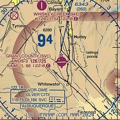
| Sectional chart |
|---|
|
| Airport distance calculator |
|---|
|
|
| Sunrise and sunset |
|---|
|
Times for 19-Jul-2026
| | Local
(UTC-6) | | Zulu
(UTC) |
|---|
| Morning civil twilight | | 05:51 | | 11:51 |
| Sunrise | | 06:19 | | 12:19 |
| Sunset | | 20:19 | | 02:19 |
| Evening civil twilight | | 20:46 | | 02:46 |
|
| Current date and time |
|---|
| Zulu (UTC) | 19-Jul-2026 14:50:07 |
|---|
| Local (UTC-6) | 19-Jul-2026 08:50:07 |
|---|
|
| METAR |
|---|
| KSVC | 191435Z AUTO 31010KT 10SM CLR 20/17 A3022 RMK AO2 T01970167
|
|
| TAF |
|---|
KDMN
31nm SE | 191126Z 1912/2012 25005KT P6SM FEW080 SCT120 FM192100 23010KT P6SM VCTS SCT070CB BKN120 PROB30 1922/2002 4SM -TSRA BKN070CB FM200400 24008KT P6SM BKN090
|
|
| NOTAMs |
|---|
NOTAMs are issued by the DoD/FAA and will open in a separate window not controlled by AirNav.
|
|


