FAA INFORMATION EFFECTIVE 09 JULY 2026
Location
| FAA Identifier: | DMN |
| Lat/Long: | 32-15-44.6000N 107-43-08.4000W
32-15.743333N 107-43.140000W
32.2623889,-107.7190000
(estimated) |
| Elevation: | 4314 ft. / 1314.9 m (surveyed) |
| Variation: | 10E (2005) |
| From city: | 2 miles SE of DEMING, NM |
| Time zone: | UTC -6 (UTC -7 during Standard Time) |
| Zip code: | 88030 |
Airport Operations
| Airport use: | Open to the public |
| Activation date: | 10/1937 |
| Control tower: | no |
| ARTCC: | ALBUQUERQUE CENTER |
| FSS: | ALBUQUERQUE FLIGHT SERVICE STATION |
| NOTAMs facility: | DMN (NOTAM-D service available) |
| Attendance: | 0700-1800
AFT HR - 575-494-2311. |
| Wind indicator: | lighted |
| Segmented circle: | no |
| Lights: | ACTVT PAPI RWY 04, 08, 22, 26; MIRL RWY 08/26 - CTAF. 1730-2230 PAPI RWY 04, 08, 22, 26; MIRL RWY 08/26 PRESET LOW INTST; INCR INTST - CTAF. |
| Beacon: | white-green (lighted land airport)
Operates sunset to sunrise. |
Airport Communications
| CTAF/UNICOM: | 122.8 |
| WX ASOS: | 118.525 (575-544-4347) |
- APCH/DEP SVC PRVDD BY ALBUQUERQUE ARTCC (ABQ) ON FREQS 128.2/285.5 (EL PASO/B/ RCAG).
Nearby radio navigation aids
| VOR radial/distance | | VOR name | | Freq | | Var |
|---|
| DMNr250/5.8 | | DEMING VORTAC | | 108.60 | | 12E |
| CUSr333/27.6 | | COLUMBUS VOR/DME | | 111.20 | | 12E |
| SVCr122/31.7 | | SILVER CITY VOR/DME | | 115.75 | | 13E |
Airport Services
| Fuel available: | 100LL JET-A1+ |
| Parking: | hangars and tiedowns |
Runway Information
Runway 8/26
| Dimensions: | 8018 x 75 ft. / 2444 x 23 m |
| Surface: | asphalt, in good condition |
| Weight bearing capacity: | | PCN 9 /F/D/X/T | | Single wheel: | 20.0 |
|
| Runway edge lights: | medium intensity |
| RUNWAY 8 | | RUNWAY 26 |
| Latitude: | 32-15.781210N | | 32-15.787457N |
| Longitude: | 107-43.703847W | | 107-42.147892W |
| Elevation: | 4314.0 ft. | | 4288.5 ft. |
| Traffic pattern: | left | | left |
| Runway heading: | 080 magnetic, 090 true | | 260 magnetic, 270 true |
| Markings: | nonprecision, in good condition | | nonprecision, in fair condition |
| Visual slope indicator: | 4-light PAPI on left (3.00 degrees glide path) | | 4-light PAPI on left (3.00 degrees glide path) |
| Touchdown point: | yes, no lights | | yes, no lights |
| Obstructions: | 10 ft. brush, 260 ft. from runway, 75 ft. right of centerline, 6:1 slope to clear
3 FT TO 4 FT BRUSH 65 FT FM THR, 3 FT TO 8 FT BRUSH 80 FT FM THR 75 FT LEFT OF CNTRLN. | | none
6 FT BRUSH 160 FT. FM THR, 110 FT. RIGHT OF CNTRLN. |
Runway 4/22
| Dimensions: | 5675 x 60 ft. / 1730 x 18 m |
| Surface: | asphalt, in good condition |
| Weight bearing capacity: | | PCN 7 /F/D/X/T | | Single wheel: | 12.0 |
|
| Runway edge lights: | medium intensity |
| RUNWAY 4 | | RUNWAY 22 |
| Latitude: | 32-15.394292N | | 32-15.975860N |
| Longitude: | 107-43.875070W | | 107-43.012388W |
| Elevation: | 4310.7 ft. | | 4302.8 ft. |
| Traffic pattern: | left | | left |
| Runway heading: | 042 magnetic, 052 true | | 222 magnetic, 232 true |
| Markings: | nonprecision, in good condition | | nonprecision, in good condition |
| Visual slope indicator: | 2-light PAPI on left (3.00 degrees glide path) | | 2-light PAPI on left (3.00 degrees glide path) |
| Touchdown point: | yes, no lights | | yes, no lights |
| Obstructions: | 8 ft. brush, 340 ft. from runway, 70 ft. right of centerline, 17:1 slope to clear
5 FT BRUSH 100-160 FT FM THR 70 FT LEFT & RIGHT OF CNTRLN. | | 8 ft. brush, 200 ft. from runway, 75 ft. left of centerline
+3-8 FT BRUSH 60-200 FT FM THR 75 FT R & L OF CNTRLN. |
Airport Ownership and Management from official FAA records
| Ownership: | Publicly-owned |
| Owner: | CITY OF DEMING
PO BOX 706
DEMING, NM 88031
Phone 575-546-8848 |
| Manager: | AZUCENA VARGAS
1275 E. PINE ST
DEMING, NM 88030
Phone 575-546-8848
575-494-2311 ALTERNATE |
Additional Remarks
| - | HEL ARR & DEP E; RMN N OF SEGMENTED CIRCLE. |
| - | INTXN TKOF NA. |
| - | FOR CD IF UNA TO CTC ON FSS FREQ, CTC ALBUQUERQUE ARTCC AT 505-856-4561. |
Instrument Procedures
NOTE: All procedures below are presented as PDF files. If you need a reader for these files, you should download the free Adobe Reader.NOT FOR NAVIGATION. Please procure official charts for flight.
FAA instrument procedures published for use from 09 July 2026 at 0901Z to 06 August 2026 at 0900Z.
IAPs - Instrument Approach Procedures |
|---|
| RNAV (GPS) RWY 04 | |
download (239KB) |
| RNAV (GPS) RWY 08 | |
download (233KB) |
| RNAV (GPS) RWY 22 | |
download (256KB) |
| RNAV (GPS)-A | |
download (213KB) |
| VOR-B | |
download (166KB) |
| NOTE: Special Alternate Minimums apply | |
download (144KB) |
| NOTE: Special Take-Off Minimums/Departure Procedures apply | |
download (292KB) |
Other nearby airports with instrument procedures:
KSVC - Grant County Airport (32 nm NW)
KLRU - Las Cruces International Airport (40 nm E)
KDNA - Dona Ana County International Jetport Airport (56 nm SE)
KTCS - Truth or Consequences Municipal Airport (63 nm N)
KBIF - Biggs Army Airfield (Fort Bliss) (72 nm E)
|
|

Road maps at:
MapQuest
Bing
Google
| Aerial photo |
|---|
WARNING: Photo may not be current or correct
 Photo courtesy of AirNav, LLC
Photo taken 09-Nov-2013
looking north-northeast.
Photo courtesy of AirNav, LLC
Photo taken 09-Nov-2013
looking north-northeast.
Do you have a better or more recent aerial photo of Deming Municipal Airport that you would like to share? If so, please send us your photo.
|
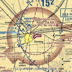
| Sectional chart |
|---|
|
| Airport distance calculator |
|---|
|
|
| Sunrise and sunset |
|---|
|
Times for 30-Jul-2026
| | Local
(UTC-6) | | Zulu
(UTC) |
|---|
| Morning civil twilight | | 05:59 | | 11:59 |
| Sunrise | | 06:25 | | 12:25 |
| Sunset | | 20:09 | | 02:09 |
| Evening civil twilight | | 20:36 | | 02:36 |
|
| Current date and time |
|---|
| Zulu (UTC) | 30-Jul-2026 20:00:22 |
|---|
| Local (UTC-6) | 30-Jul-2026 14:00:22 |
|---|
|
| METAR |
|---|
| KDMN | 301553Z AUTO 00000KT 10SM CLR 33/12 A3009 RMK AO2 SLP092 T03280117
|
|
| TAF |
|---|
| KDMN | 301720Z 3018/3118 07006KT P6SM FEW120 FM310100 33010KT P6SM VCTS SCT100CB FM310500 30008KT P6SM SCT120 FM311400 03006KT P6SM FEW150
|
|
| NOTAMs |
|---|
NOTAMs are issued by the DoD/FAA and will open in a separate window not controlled by AirNav.
|
|


