FAA INFORMATION EFFECTIVE 11 JUNE 2026
Location
| FAA Identifier: | SYF |
| Lat/Long: | 39-45-33.0000N 101-47-40.7970W
39-45.550000N 101-47.679950W
39.7591667,-101.7946658
(estimated) |
| Elevation: | 3429.5 ft. / 1045 m (estimated) |
| Variation: | 06E (2020) |
| From city: | 1 mile S of ST FRANCIS, KS |
| Time zone: | UTC -5 (UTC -6 during Standard Time) |
| Zip code: | 67756 |
Airport Operations
| Airport use: | Open to the public |
| Activation date: | 03/1945 |
| Control tower: | no |
| ARTCC: | DENVER CENTER |
| FSS: | WICHITA FLIGHT SERVICE STATION |
| NOTAMs facility: | ICT (NOTAM-D service available) |
| Attendance: | |
| Wind indicator: | lighted |
| Segmented circle: | no |
| Lights: | ACTVT MIRL RWY 14/32 - CTAF. |
| Beacon: | white-green (lighted land airport)
Operates sunset to sunrise. |
Airport Communications
| CTAF/UNICOM: | 122.8 |
| WX AWOS-3P: | 118.925 (785-306-1050) |
- APCH/DEP CTL SVC PRVDD BY DENVER ARTCC (ZDV) ON FREQS 132.7/226.675 (GOODLAND RCAG).
Nearby radio navigation aids
| VOR radial/distance | | VOR name | | Freq | | Var |
|---|
| GLDr336/22.8 | | GOODLAND VORTAC | | 115.10 | | 12E |
| NDB name | | Hdg/Dist | | Freq | | Var | | ID |
|---|
| KIT CARSON | | 030/38.2 | | 209 | | 06E | | ITR | .. - .-. |
Airport Services
| Fuel available: | 100LL |
| Parking: | tiedowns |
Runway Information
Runway 14/32
| Dimensions: | 5200 x 75 ft. / 1585 x 23 m |
| Surface: | concrete, in excellent condition |
| Weight bearing capacity: | | Single wheel: | 30.0 | | Double wheel: | 30.0 |
|
| Runway edge lights: | medium intensity |
| RUNWAY 14 | | RUNWAY 32 |
| Latitude: | 39-45.827887N | | 39-45.126512N |
| Longitude: | 101-48.021640W | | 101-47.384968W |
| Elevation: | 3389.4 ft. | | 3429.5 ft. |
| Traffic pattern: | left | | left |
| Runway heading: | 139 magnetic, 145 true | | 319 magnetic, 325 true |
| Displaced threshold: | 200 ft. | | no |
| Declared distances: | TORA:5200 TODA:5200 ASDA:5200 LDA:5000 | | TORA:5200 TODA:5200 ASDA:5200 LDA:5200 |
| Markings: | nonprecision, in good condition | | nonprecision, in good condition |
| Touchdown point: | yes, no lights | | yes, no lights |
| Obstructions: | 36 ft. trees, 662 ft. from runway, 214 ft. right of centerline, 12:1 slope to clear | | none |
Runway 18/36
| Dimensions: | 2313 x 280 ft. / 705 x 85 m |
| Surface: | turf, in good condition |
| RUNWAY 18 | | RUNWAY 36 |
| Latitude: | 39-45.893638N | | 39-45.533620N |
| Longitude: | 101-47.546863W | | 101-47.708180W |
| Elevation: | 3379.9 ft. | | 3407.4 ft. |
| Traffic pattern: | left | | left |
| Runway heading: | 193 magnetic, 199 true | | 013 magnetic, 019 true |
| Obstructions: | 15 ft. road, 55 ft. from runway, 3:1 slope to clear
35 FT PLINE AT 450 FT 0B. | | none |
Airport Ownership and Management from official FAA records
| Ownership: | Publicly-owned |
| Owner: | CHEYENNE COUNTY
212 E. WASHINGTON ST, PO BOX 985
ST. FRANCIS, KS 67756
Phone 785-772-7079 |
| Manager: | MICHAEL HANSON
212 E. WASHINGTON ST, PO BOX 517
ST. FRANCIS, KS 67756
Phone 785-332-8844 |
Additional Remarks
| - | FOR CD CTC DENVER ARTCC AT 303-651-4257. |
Instrument Procedures
NOTE: All procedures below are presented as PDF files. If you need a reader for these files, you should download the free Adobe Reader.NOT FOR NAVIGATION. Please procure official charts for flight.
FAA instrument procedures published for use from 11 June 2026 at 0901Z to 09 July 2026 at 0900z.
IAPs - Instrument Approach Procedures |
|---|
| RNAV (GPS) RWY 14 **CHANGED** | |
download (197KB) |
| RNAV (GPS) RWY 32 **CHANGED** | |
download (222KB) |
| NOTE: Special Alternate Minimums apply | |
download (147KB) |
| NOTE: Special Take-Off Minimums/Departure Procedures apply | |
download (271KB) |
Other nearby airports with instrument procedures:
KGLD - Renner Field/Goodland Municipal Airport (24 nm S)
2V5 - Wray Municipal Airport (29 nm NW)
KADT - Atwood/Rawlins County Airport (35 nm E)
KITR - Kit Carson County Airport (38 nm SW)
KCBK - Shalz Field Airport (40 nm SE)
|
|

Road maps at:
MapQuest
Bing
Google
| Aerial photo |
|---|
WARNING: Photo may not be current or correct
 Photo courtesy of Grace Flying Service
Photo taken 27-Oct-2018
looking southeast.
Photo courtesy of Grace Flying Service
Photo taken 27-Oct-2018
looking southeast.
Do you have a better or more recent aerial photo of Cheyenne County Municipal Airport that you would like to share? If so, please send us your photo.
|
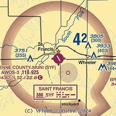
| Sectional chart |
|---|
|
| Airport distance calculator |
|---|
|
|
| Sunrise and sunset |
|---|
|
Times for 14-Jun-2026
| | Local
(UTC-5) | | Zulu
(UTC) |
|---|
| Morning civil twilight | | 05:47 | | 10:47 |
| Sunrise | | 06:19 | | 11:19 |
| Sunset | | 21:15 | | 02:15 |
| Evening civil twilight | | 21:48 | | 02:48 |
|
| Current date and time |
|---|
| Zulu (UTC) | 14-Jun-2026 22:21:01 |
|---|
| Local (UTC-5) | 14-Jun-2026 17:21:01 |
|---|
|
| METAR |
|---|
| KSYF | 142135Z AUTO VRB05KT 10SM BKN075 21/05 A3022 RMK AO2
|
|
| TAF |
|---|
KGLD
24nm S | 141720Z 1418/1518 VRB06KT P6SM SCT070 FM150000 08011KT P6SM BKN090 FM150600 VRB06KT P6SM SCT080 FM151600 17012KT P6SM BKN045
|
|
| NOTAMs |
|---|
NOTAMs are issued by the DoD/FAA and will open in a separate window not controlled by AirNav.
|
|

