FAA INFORMATION EFFECTIVE 14 MAY 2026
Location
| FAA Identifier: | TDW |
| Lat/Long: | 35-10-11.6000N 101-49-33.1000W
35-10.193333N 101-49.551667W
35.1698889,-101.8258611
(estimated) |
| Elevation: | 3648.5 ft. / 1112.1 m (surveyed) |
| Variation: | 08E (2000) |
| From city: | 3 miles SE of AMARILLO, TX |
| Time zone: | UTC -5 (UTC -6 during Standard Time) |
| Zip code: | 79118 |
Airport Operations
| Airport use: | Open to the public |
| Activation date: | 10/1963 |
| Control tower: | no |
| ARTCC: | ALBUQUERQUE CENTER |
| FSS: | FORT WORTH FLIGHT SERVICE STATION |
| NOTAMs facility: | FTW (NOTAM-D service available) |
| Attendance: | 0700-2200
AFT HRS SVC 806-376-1008. |
| Wind indicator: | lighted |
| Segmented circle: | yes |
| Lights: | MIRL RWY 17/35 SS-SR PRESET LOW. TO INCR INTST AND ACTVT REIL RWY 17, 35; MIRL RWY 05/23 - CTAF. |
| Beacon: | white-green (lighted land airport)
Operates sunset to sunrise. |
Airport Communications
| CTAF/UNICOM: | 122.8 |
| WX AWOS-AV: | 118.475 (806-350-7407) |
| AMARILLO APPROACH: | 119.5 |
| ALBUQUERQUE ARTCC APPROACH: | 121.15 |
| AMARILLO DEPARTURE: | 119.5 |
| ALBUQUERQUE ARTCC DEPARTURE: | 121.15 |
| CLEARANCE DELIVERY: | 125.4 |
| WX ASOS at AMA (7 nm NE): | 118.85 (806-223-2973) |
- APCH/DEP SVC PRVDD BY ALBUQUERQUE ARTCC (ZAB) ON FREQS 127.85/285.475 (AMARILLO RCAG) WHEN AMARILLO APCH CTL (AMA) CLSD.
Nearby radio navigation aids
| VOR radial/distance | | VOR name | | Freq | | Var |
|---|
| PNHr230/7.3 | | PANHANDLE VORTAC | | 116.60 | | 08E |
| NDB name | | Hdg/Dist | | Freq | | Var | | ID |
|---|
| PANDE | | 317/1.7 | | 251 | | 08E | | AM | .- -- |
Airport Services
| Fuel available: | 100LL JET-A1+ |
| Parking: | hangars and tiedowns |
| Airframe service: | MAJOR |
| Powerplant service: | MAJOR |
| Bottled oxygen: | HIGH |
Runway Information
Runway 17/35
| Dimensions: | 5098 x 60 ft. / 1554 x 18 m |
| Surface: | asphalt, in fair condition |
| Weight bearing capacity: | |
| Runway edge lights: | medium intensity |
| RUNWAY 17 | | RUNWAY 35 |
| Latitude: | 35-10.685687N | | 35-09.845475N |
| Longitude: | 101-49.586512W | | 101-49.584298W |
| Elevation: | 3648.5 ft. | | 3639.2 ft. |
| Traffic pattern: | right | | left |
| Runway heading: | 172 magnetic, 180 true | | 352 magnetic, 360 true |
| Displaced threshold: | 290 ft. | | 289 ft. |
| Markings: | basic, in good condition | | basic, in good condition |
| Runway end identifier lights: | yes | | yes |
| Touchdown point: | yes, no lights | | yes, no lights |
| Obstructions: | 30 ft. tree, 201 ft. from runway, 133 ft. right of centerline
4 FT FENCE 24 FT DSTC; 14 FT RD 43 FT DSTC, 250 L/R. | | 30 ft. trees, 300 ft. from runway, 220 ft. right of centerline, 3:1 slope to clear
4 FT FENCE 0 FT DSTC; 15 FT RD, 47 FT DSTC. |
Runway 5/23
| Dimensions: | 3000 x 60 ft. / 914 x 18 m |
| Surface: | asphalt, in fair condition |
| Weight bearing capacity: | |
| Runway edge lights: | medium intensity |
| RUNWAY 5 | | RUNWAY 23 |
| Latitude: | 35-09.930378N | | 35-10.207658N |
| Longitude: | 101-49.743048W | | 101-49.244647W |
| Elevation: | 3642.6 ft. | | 3626.9 ft. |
| Traffic pattern: | left | | right |
| Runway heading: | 048 magnetic, 056 true | | 228 magnetic, 236 true |
| Markings: | none, in poor condition | | none, in poor condition |
| Touchdown point: | yes, no lights | | yes, no lights |
| Obstructions: | 4 ft. fence, 200 ft. from runway, 99 ft. right of centerline
4 FT FENCE 0 FT DSTC, 99 FT R. | | 23 ft. pole, 854 ft. from runway, 29 ft. left of centerline, 29:1 slope to clear
6 FT FENCE 94 FT DSTC, 60 FT L. |
Helipad H1
| Dimensions: | 50 x 50 ft. / 15 x 15 m |
| Surface: | asphalt, in fair condition |
| Latitude: | 35-10.250000N | | |
| Longitude: | 101-49.800000W | | |
| Elevation: | 3648.5 ft. | | |
| Traffic pattern: | left | | left |
| Markings: | none, in fair condition | | |
Airport Ownership and Management from official FAA records
| Ownership: | Privately-owned |
| Owner: | TRADEWIND FBO DBA TRADEWIND ARPT
4105 TRADEWIND ST
AMARILLO, TX 79118
Phone 806-376-1008 |
| Manager: | JON KUEHLER
4105 TRADEWIND ST
AMARILLO, TX 79118
Phone 806-376-1008
CELL 720-412-1132 |
Additional Remarks
| - | FOR CD CTC ALBUQUERQUE ARTCC AT 505-856-4861. |
| - | RWY 5/23 NO MKGS. |
| A52-H1 | 35 FT PLINE 440 FT SOUTH OF HELIPAD; 35 FT PLINE, MKD 157 FT WEST; 30 FT LGT POLE 171 FT EAST, 25 FT LGTD WIND SOCK 96 FT WEST. |
Instrument Procedures
NOTE: All procedures below are presented as PDF files. If you need a reader for these files, you should download the free Adobe Reader.NOT FOR NAVIGATION. Please procure official charts for flight.
FAA instrument procedures published for use from 14 May 2026 at 0901Z to 11 June 2026 at 0900Z.
IAPs - Instrument Approach Procedures |
|---|
| RNAV (GPS) RWY 35 | |
download (224KB) |
| NOTE: Special Take-Off Minimums/Departure Procedures apply | |
download (113KB) |
Other nearby airports with instrument procedures:
KAMA - Rick Husband Amarillo International Airport (7 nm NE)
T45 - Panhandle-Carson County Airport (25 nm NE)
KHRX - Hereford Municipal Airport (31 nm SW)
KBGD - Hutchinson County Airport (38 nm NE)
KDUX - Moore County Airport (42 nm N)
|
|

Road maps at:
MapQuest
Bing
Google
| Aerial photo |
|---|
WARNING: Photo may not be current or correct
 Photo taken 18-Jan-2005
Do you have a better or more recent aerial photo of Tradewind Airport that you would like to share? If so, please send us your photo.
|
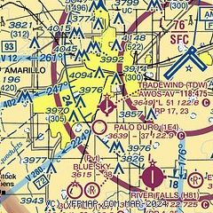
| Sectional chart |
|---|
|
| Airport distance calculator |
|---|
|
|
| Sunrise and sunset |
|---|
|
Times for 05-Jun-2026
| | Local
(UTC-5) | | Zulu
(UTC) |
|---|
| Morning civil twilight | | 06:05 | | 11:05 |
| Sunrise | | 06:34 | | 11:34 |
| Sunset | | 20:58 | | 01:58 |
| Evening civil twilight | | 21:27 | | 02:27 |
|
| Current date and time |
|---|
| Zulu (UTC) | 05-Jun-2026 07:05:27 |
|---|
| Local (UTC-5) | 05-Jun-2026 02:05:27 |
|---|
|
| METAR |
|---|
KAMA
7nm NE | 050653Z AUTO 19009KT 10SM CLR 19/16 A2999 RMK AO2 SLP107 T01940156 $
|
|
| TAF |
|---|
KAMA
7nm NE | 050520Z 0506/0606 18009KT P6SM SCT230 FM051500 22010KT P6SM SCT250 FM051800 19010KT P6SM BKN230 FM052300 16014KT P6SM SCT220
|
|
| NOTAMs |
|---|
NOTAMs are issued by the DoD/FAA and will open in a separate window not controlled by AirNav.
|
|


