FAA INFORMATION EFFECTIVE 07 AUGUST 2025
Location
| FAA Identifier: | KTN |
| Lat/Long: | 55-21-14.7000N 131-42-40.4000W
55-21.245000N 131-42.673333W
55.3540833,-131.7112222
(estimated) |
| Elevation: | 92.4 ft. / 28.2 m (surveyed) |
| Variation: | 21E (2010) |
| From city: | 1 mile W of KETCHIKAN, AK |
| Time zone: | UTC -8 (UTC -9 during Standard Time) |
| Zip code: | 99901 |
Airport Operations
| Airport use: | Open to the public |
| Activation date: | 04/1973 |
| Control tower: | no |
| ARTCC: | ANCHORAGE CENTER |
| FSS: | KETCHIKAN FLIGHT SERVICE STATION (on field) [907-225-9481] |
| Alternate FSS: | JNU JUNEAU FLIGHT SERVICE STATION [1-866-297-2236] |
| NOTAMs facility: | KTN (NOTAM-D service available) |
| Attendance: | 0600-2130 |
| Wind indicator: | lighted |
| Segmented circle: | yes |
| Lights: | WHEN KTN FSS CLSD ACTVT MALSR RWY 11 & 29; HIRL RWY 11/29 - CTAF. PAPI RWY 11 & 29 OPR CONSLY. |
| Beacon: | white-green (lighted land airport)
WHEN KTN FSS CLSD OPR CONSLY. |
| Landing fee: | yes, LNDG FEE FOR GA ACFT UNDER 6000 LB & FLOAT PLANE USE OF SPB FLOAT. |
| Fire and rescue: | ARFF index B |
| Airline operations: | ACR OPS MORE THAN 30 PAX NA IN EXCESS OF 15 MIN BFR OR AFT SKED ARR OR DEP WO PPR WITH AMGR & CFM ARFF SVC AVBL BFR LDG OR TKOF. |
| International operations: | customs landing rights airport |
Airport Communications
| CTAF: | 123.6 |
| WX ASOS: | 134.45 (907-247-8801) |
| WX AWOS-3P at MTM (14 nm S): | 135.55 (907-886-7989) |
- APCH/DEP SVC PRVDD BY ANCHORAGE ARTCC ON FREQS 118.5/284.6 (ANNETTE ISLAND RCAG).
- KTN AFIS ON FREQUENCY 134.45. OPERATES SAME HRS AS KTN FSS, 0615-2115;OT JUNEAU FSS,
- COMMUNICATIONS PRVDD BY KETCHIKAN FSS ON FREQ 123.6 (CTAF).
Nearby radio navigation aids
| VOR radial/distance | | VOR name | | Freq | | Var |
|---|
| ANNr325/18.2 | | ANNETTE ISLAND VOR/DME | | 117.10 | | 21E |
| NDB name | | Hdg/Dist | | Freq | | Var | | ID |
|---|
| CLAM COVE | | at field | | 396 | | 21E | | CMJ | -.-. -- .--- |
Airport Services
| Fuel available: | 100LL JET-A
100LL:0630-2030 - 122.95 OR 907-531-9891. |
| Parking: | hangars and tiedowns |
Runway Information
Runway 11/29
| Dimensions: | 7500 x 150 ft. / 2286 x 46 m |
| Surface: | asphalt/grooved, in good condition |
| Weight bearing capacity: | | Single wheel: | 120.0 | | Double wheel: | 207.0 | | Double tandem: | 350.0 |
|
| Runway edge lights: | high intensity |
| Operational restrictions: | SAND USED TO ENHANCE FRICTION MAY NOT MEET FAA SPECS. |
| RUNWAY 11 | | RUNWAY 29 |
| Latitude: | 55-21.684727N | | 55-20.804465N |
| Longitude: | 131-43.429605W | | 131-41.916590W |
| Elevation: | 84.9 ft. | | 89.2 ft. |
| Traffic pattern: | right
WX PMTG FOR LIGHT SINGLE/TWIN ENG. | | left |
| Runway heading: | 115 magnetic, 136 true | | 295 magnetic, 316 true |
| Markings: | precision, in good condition | | precision, in good condition |
| Visual slope indicator: | 4-light PAPI on left (3.00 degrees glide path)
PAPI UNUSBL 5 DEGS LEFT AND RIGHT OF CNTRLN. | | 4-light PAPI on left (3.00 degrees glide path)
PAPI UNUSBL BYD 6 NM. |
| RVR equipment: | touchdown, rollout | | touchdown, rollout |
| Approach lights: | MALSR: 1,400 foot medium intensity approach lighting system with runway alignment indicator lights | | MALSR: 1,400 foot medium intensity approach lighting system with runway alignment indicator lights |
| Touchdown point: | yes, no lights | | yes, no lights |
| Instrument approach: | ILS/DME | | |
| Obstructions: | 103 ft. trees, 3300 ft. from runway | | none |
Runway WNW/ESE
| Dimensions: | 9500 x 1500 ft. / 2896 x 457 m |
| Surface: | water |
| RUNWAY ESE | | RUNWAY WNW |
| Traffic pattern: | left | | left |
Airport Ownership and Management from official FAA records
| Ownership: | Publicly-owned |
| Owner: | ALASKA DOT&PF SOUTHCOAST REGION
6860 GLACIER HIGHWAY
JUNEAU, AK 99801-7999
Phone 907-465-1786 |
| Manager: | ALEX PUERA
1000 ARPT TERMINAL WAY
KETCHIKAN, AK 99901
Phone 907-225-6800
ALEX PEURA |
Additional Remarks
| A39-11/29 | PCR VALUE: 510/F/B/X/T |
| - | TRRN CAUSES TURB ON ARR & DEP ROUTES. |
| - | USCG HELI 55-21-27.6N/131-42-19.8W; INVOF KETCHIKAN INTL ARPT & SEAPLAN BASE; MED-VAC MISSIONS ONLY - POC COMMANDER CG DISTRICT 17, 709 W 9TH ST, RM 661. BOX 25517 JUNEAU, AK 99802 - 907-463-2247/2000. |
| - | WX CAMERAS AVBL ON INTERNET AT HTTPS://WEATHERCAMS.FAA.GOV |
| - | TWY C LGTS OTS INDEF. |
| - | PPR FOR LDG DURG UNATNDD HRS - FBO 907-531-9891 FOR ARNGMT & CALL OUT CHARGE. |
| - | ALERT: SPL ATC RULES PART 93 & STD VFR ARR & DEP PROC & PAT INFO - SEE REG NOTICE. |
| - | GA APRON; TWY C; NE SECTION OF MAIN APRON PCN 21/F/B/X/T. |
| - | DOCK W OF ARPT CLSD NOV 1 - APR 1; PPR OVNGT - AMGR; FERRY BTW ARPT & CITY OPR CONSLY WHEN ARPT ATNDD. |
| - | BIRDS ON & INVOF ARPT. |
| - | PRIOR TO OPS ON APRON/TWY ALL ACFT CTC KTN FSS & ADZ INTNS. |
| - | SFC COND RPRTS REFLECT CONDS WHILE ARPT ATNDD ONLY. |
| - | CTN AIR TAXI & BOATS IN HARBOR; FLOATING DEBRIS PSBL. |
| - | SNOW & ICE REMOVAL NA WHEN ARPT UNATTND. |
Instrument Procedures
NOTE: All procedures below are presented as PDF files. If you need a reader for these files, you should download the free Adobe Reader.NOT FOR NAVIGATION. Please procure official charts for flight.
FAA instrument procedures published for use from 07 August 2025 at 0901Z to 04 September 2025 at 0900z.
IAPs - Instrument Approach Procedures |
|---|
| ILS Y OR LOC Y RWY 11 | |
download (460KB) |
| ILS Z OR LOC Z RWY 11 | |
download (445KB) |
| RNAV (GPS) RWY 11 | |
download (368KB) |
| RNAV (GPS) RWY 29 | |
download (331KB) |
| RNAV (GPS)-B | |
download (302KB) |
| LOC X RWY 11 | |
download (450KB) |
| NOTE: Special Alternate Minimums apply | |
download (174KB) |
|
|---|
| KETCHIKAN SIX (OBSTACLE) | |
download (192KB) |
| SKOWL TWO (OBSTACLE) | |
download (316KB) |
| NOTE: Special Take-Off Minimums/Departure Procedures apply | |
download (253KB) |
Other nearby airports with instrument procedures:
PAKW - Klawock Airport (48 nm W)
PAWG - Wrangell Airport (71 nm N)
PAPG - Petersburg James A Johnson Airport (96 nm NW)
|
|

Road maps at:
MapQuest
Bing
Google
| Aerial photo |
|---|
WARNING: Photo may not be current or correct
 Photo by Randy Elkins C-FIQV
Do you have a better or more recent aerial photo of Ketchikan International Airport that you would like to share? If so, please send us your photo.
|
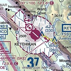
| Sectional chart |
|---|
|
 Download PDF
of official airport diagram from the FAA
| Airport distance calculator |
|---|
|
|
| Sunrise and sunset |
|---|
|
Times for 30-Aug-2025
| | Local
(UTC-8) | | Zulu
(UTC) |
|---|
| Morning civil twilight | | 05:11 | | 13:11 |
| Sunrise | | 05:50 | | 13:50 |
| Sunset | | 19:45 | | 03:45 |
| Evening civil twilight | | 20:24 | | 04:24 |
|
| Current date and time |
|---|
| Zulu (UTC) | 30-Aug-2025 23:05:56 |
|---|
| Local (UTC-8) | 30-Aug-2025 15:05:56 |
|---|
|
| METAR |
|---|
| PAKT | 302253Z 11011KT 10SM CLR 19/14 A3013 RMK AO2 SLP201 HARBOR WIND 10010KT T01940139
|
PAMM
14nm S | 302256Z AUTO 23013KT 10SM CLR 17/14 A3014 RMK AO2 SLP197 T01670139 $
|
|
| TAF |
|---|
| PAKT | 301731Z 3018/3118 15006KT P6SM SCT007 BKN011 FM302200 32012KT P6SM SCT050
|
|
| NOTAMs |
|---|
NOTAMs are issued by the DoD/FAA and will open in a separate window not controlled by AirNav.
|
|


