FAA INFORMATION EFFECTIVE 14 MAY 2026
Location
| FAA Identifier: | VTA |
| Lat/Long: | 40-01-28.8000N 082-27-42.5000W
40-01.480000N 082-27.708333W
40.0246667,-82.4618056
(estimated) |
| Elevation: | 883.8 ft. / 269.4 m (surveyed) |
| Variation: | 06W (1990) |
| From city: | 3 miles SW of NEWARK, OH |
| Time zone: | UTC -4 (UTC -5 during Standard Time) |
| Zip code: | 43056 |
Airport Operations
| Airport use: | Open to the public |
| Activation date: | 12/1937 |
| Control tower: | no |
| ARTCC: | INDIANAPOLIS CENTER |
| FSS: | DAYTON FLIGHT SERVICE STATION |
| NOTAMs facility: | VTA (NOTAM-D service available) |
| Attendance: | MON-SAT 0800-1700, ALL SUN 1200-1700 |
| Pattern altitude: | 1899.8 ft. MSL |
| Wind indicator: | lighted |
| Segmented circle: | no |
| Lights: | ACTVT OR INCR INTST REIL RWY 09 & 27; MIRL RWY 09/27 - 123.3. PAPI RWY 09 & 27 OPR CONSLY; MIRL RWY 09/27 OPR CONSLY LOW INTST. |
| Beacon: | white-green (lighted land airport)
Operates sunset to sunrise. |
| Landing fee: | yes, LDG FEE FOR ACFT 10000 LB OR GTR - WAIVED WITH MNM FUEL PURCHASE. |
Airport Communications
| CTAF/UNICOM: | 122.7 |
| WX ASOS: | 121.125 (740-522-1066) |
| COLUMBUS APPROACH: | 125.95 |
| COLUMBUS DEPARTURE: | 125.95 |
| CLEARANCE DELIVERY: | 125.175 |
| IC: | 125.95 |
| WX ASOS at LHQ (18 nm SW): | 118.375 (740-681-1097) |
| WX AWOS-3PT at 4I3 (18 nm N): | 126.05 (740-397-6297) |
| WX ASOS at CMH (20 nm W): | 124.6 (614-333-9354) |
Nearby radio navigation aids
| VOR radial/distance | | VOR name | | Freq | | Var |
|---|
| APEr149/9.6 | | APPLETON VORTAC | | 116.70 | | 06W |
| XUBr044/(38.2) | | YELLOW BUD VOR | | 112.50 | | 05W |
Airport Services
| Fuel available: | 100LL JET-A1 JET-A1+
100LL:100LL AVBL H24 VIA CREDIT CARD. |
| Parking: | hangars and tiedowns |
| Airframe service: | MAJOR |
| Powerplant service: | MAJOR |
| Bottled oxygen: | NONE |
| Bulk oxygen: | HIGH/LOW |
Runway Information
Runway 9/27
| Dimensions: | 4649 x 75 ft. / 1417 x 23 m |
| Surface: | asphalt, in good condition |
| Weight bearing capacity: | |
| Runway edge lights: | medium intensity |
| RUNWAY 9 | | RUNWAY 27 |
| Latitude: | 40-01.459148N | | 40-01.499833N |
| Longitude: | 082-28.206095W | | 082-27.211647W |
| Elevation: | 882.4 ft. | | 869.8 ft. |
| Traffic pattern: | left | | left |
| Runway heading: | 093 magnetic, 087 true | | 273 magnetic, 267 true |
| Displaced threshold: | 457 ft. | | no |
| Markings: | nonprecision, in good condition | | nonprecision, in good condition |
| Visual slope indicator: | 4-light PAPI on left (3.00 degrees glide path) | | 4-light PAPI on left (3.25 degrees glide path) |
| Runway end identifier lights: | yes | | yes |
| Touchdown point: | yes, no lights | | yes, no lights |
| Instrument approach: | LOCALIZER | | |
| Obstructions: | 15 ft. road, 200 ft. from runway, 168 ft. right of centerline
+15 FT ROAD, 0-200 FT DIST, 168-218 FT R; +11 FT FENCE, 0-200 FT DIST, 129-198 FT R. | | 4 ft. berm, 200 ft. from runway, 155 ft. left of centerline
+5 FT BERM, 0-200 FT DIST, 155 FT L/R. |
Airport Ownership and Management from official FAA records
| Ownership: | Publicly-owned |
| Owner: | LICKING CO RGNL ARPT AUTH
530 HEATH RD
HEATH, OH 43056-1134
Phone 740-522-6968 |
| Manager: | CAITLIN COPEN
530 HEATH RD
HEATH, OH 43056-1134
Phone 740-522-6968 |
Additional Remarks
| A30A-27 | CALM WIND RWY. |
| - | OCNL DEER, BIRDS, & OTR WILDLIFE ON & INVOF ARPT. |
Instrument Procedures
NOTE: All procedures below are presented as PDF files. If you need a reader for these files, you should download the free Adobe Reader.NOT FOR NAVIGATION. Please procure official charts for flight.
FAA instrument procedures published for use from 14 May 2026 at 0901Z to 11 June 2026 at 0900Z.
IAPs - Instrument Approach Procedures |
|---|
| RNAV (GPS) RWY 09 | |
download (207KB) |
| RNAV (GPS) RWY 27 | |
download (199KB) |
| LOC RWY 09 | |
download (182KB) |
| VOR-A | |
download (168KB) |
| NOTE: Special Alternate Minimums apply | |
download (169KB) |
| NOTE: Special Take-Off Minimums/Departure Procedures apply | |
download (478KB) |
Other nearby airports with instrument procedures:
KLHQ - Fairfield County Airport (18 nm SW)
4I3 - Knox County Airport (18 nm N)
KCMH - John Glenn Columbus International Airport (20 nm W)
I86 - Ed Newlon Field Airport (23 nm SE)
KLCK - Rickenbacker International Airport (25 nm SW)
|
|

Road maps at:
MapQuest
Bing
Google
| Aerial photo |
|---|
WARNING: Photo may not be current or correct
 Photo by Charlie Rhoads
Photo taken 11-Oct-2013
looking west.
Photo by Charlie Rhoads
Photo taken 11-Oct-2013
looking west.
Do you have a better or more recent aerial photo of Licking County Regional Airport that you would like to share? If so, please send us your photo.
|
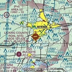
| Sectional chart |
|---|
|
| Airport distance calculator |
|---|
|
|
| Sunrise and sunset |
|---|
|
Times for 24-May-2026
| | Local
(UTC-4) | | Zulu
(UTC) |
|---|
| Morning civil twilight | | 05:37 | | 09:37 |
| Sunrise | | 06:08 | | 10:08 |
| Sunset | | 20:45 | | 00:45 |
| Evening civil twilight | | 21:17 | | 01:17 |
|
| Current date and time |
|---|
| Zulu (UTC) | 24-May-2026 17:28:08 |
|---|
| Local (UTC-4) | 24-May-2026 13:28:08 |
|---|
|
| METAR |
|---|
| KVTA | 241654Z AUTO 20003KT 10SM FEW008 OVC017 22/19 A3006 RMK AO2 CIG 011V022 SLP173 T02170194
|
K4I3
18nm N | 241715Z AUTO VRB04KT 10SM BKN009 BKN020 21/21 A3007 RMK AO2
|
KLHQ
19nm SW | 241206Z AUTO 15006KT 10SM OVC014 19/18 A3007 RMK AO2 RAE1154 P0000 T01940183 TSNO
|
KCMH
19nm W | 241651Z 19005KT 10SM BKN011 OVC017 21/19 A3006 RMK AO2 DZE03 SLP175 VCSH S P0000 T02110194 $
|
|
| TAF |
|---|
KCMH
19nm W | 241412Z 2414/2512 00000KT P6SM OVC005 FM241600 20005KT P6SM -SHRA OVC012 FM241800 23006KT 5SM -SHRA BR BKN015 OVC030 PROB30 2418/2422 2SM -TSRA BKN015CB FM242200 22005KT P6SM BKN040 OVC100 FM250500 33004KT 5SM BR BKN012
|
|
| NOTAMs |
|---|
NOTAMs are issued by the DoD/FAA and will open in a separate window not controlled by AirNav.
|
|


