FAA INFORMATION EFFECTIVE 16 APRIL 2026
Location
| FAA Identifier: | VTN |
| Lat/Long: | 42-51-24.1070N 100-32-56.2710W
42-51.401783N 100-32.937850W
42.8566964,-100.5489642
(estimated) |
| Elevation: | 2595.4 ft. / 791.1 m (surveyed) |
| Variation: | 08E (2000) |
| From city: | 1 mile S of VALENTINE, NE |
| Time zone: | UTC -5 (UTC -6 during Standard Time) |
| Zip code: | 69201 |
Airport Operations
| Airport use: | Open to the public |
| Activation date: | 09/1949 |
| Control tower: | no |
| ARTCC: | DENVER CENTER |
| FSS: | COLUMBUS FLIGHT SERVICE STATION |
| NOTAMs facility: | VTN (NOTAM-D service available) |
| Attendance: | MON-FRI 0800-1700, ALL SAT 0900-1600 |
| Wind indicator: | lighted |
| Segmented circle: | yes |
| Lights: | ACTVT MIRL RYS 03/21 & 14/32, PAPI RYS 03, 21, 14 & 32; REIL RY 32 - CTAF. |
| Beacon: | white-green (lighted land airport)
Operates sunset to sunrise. |
Airport Communications
| CTAF/UNICOM: | 122.8 |
| WX ASOS: | 118.075 (402-988-1984) |
- APCH/DEP CTL SVC PRVDD BY DENVER ARTCC (ZDV) ON FREQS 127.95/338.2 (AINSWORTH RCAG).
Nearby radio navigation aids
| VOR radial/distance | | VOR name | | Freq | | Var |
|---|
| ANWr296/30.1 | | AINSWORTH VOR/DME | | 112.70 | | 09E |
| NDB name | | Hdg/Dist | | Freq | | Var | | ID |
|---|
| VALENTINE | | at field | | 314 | | 08E | | VTN | ...- - -. |
Airport Services
| Fuel available: | 100LL JET-A
100LL:FUEL AVBL 24 HRS WITH CREDIT CARD OR BY PRIOR ARRANGEMENT CALL (402) 376-2215. |
| Parking: | tiedowns |
| Airframe service: | MAJOR |
| Powerplant service: | MAJOR |
| Bottled oxygen: | NONE |
| Bulk oxygen: | NONE |
Runway Information
Runway 14/32
| Dimensions: | 4705 x 75 ft. / 1434 x 23 m |
| Surface: | concrete, in excellent condition |
| Weight bearing capacity: | | Single wheel: | 30.0 | | Double wheel: | 42.5 |
|
| Runway edge lights: | medium intensity |
| RUNWAY 14 | | RUNWAY 32 |
| Latitude: | 42-51.710905N | | 42-51.072968N |
| Longitude: | 100-33.124405W | | 100-32.527693W |
| Elevation: | 2587.4 ft. | | 2582.8 ft. |
| Traffic pattern: | left | | left |
| Runway heading: | 137 magnetic, 145 true | | 317 magnetic, 325 true |
| Displaced threshold: | 384 ft. | | no |
| Markings: | nonprecision, in good condition | | nonprecision, in good condition |
| Visual slope indicator: | 2-light PAPI on left (3.00 degrees glide path) | | 2-light PAPI on left (3.00 degrees glide path) |
| Runway end identifier lights: | | | yes |
| Touchdown point: | yes, no lights | | yes, no lights |
| Obstructions: | none
RWY 14 APCH SLOPE 31:1 DUE TO 24 FT FIR TREES 807 FT FROM DTHR. | | 9 ft. fence, 395 ft. from runway, 21:1 slope to clear
RWY 32 234' LT @ 9', MEASURED |
Runway 3/21
| Dimensions: | 3701 x 60 ft. / 1128 x 18 m |
| Surface: | concrete, in excellent condition |
| Weight bearing capacity: | |
| Runway edge lights: | medium intensity |
| RUNWAY 3 | | RUNWAY 21 |
| Latitude: | 42-51.168853N | | 42-51.659722N |
| Longitude: | 100-33.325203W | | 100-32.834725W |
| Elevation: | 2595.4 ft. | | 2586.0 ft. |
| Traffic pattern: | left | | left |
| Runway heading: | 028 magnetic, 036 true | | 208 magnetic, 216 true |
| Displaced threshold: | no | | 299 ft. |
| Markings: | nonprecision, in good condition | | nonprecision, in good condition |
| Visual slope indicator: | 2-light PAPI on left (3.00 degrees glide path) | | 2-light PAPI on left (3.00 degrees glide path) |
| Touchdown point: | yes, no lights | | yes, no lights |
Airport Ownership and Management from official FAA records
| Ownership: | Publicly-owned |
| Owner: | CITY OF VALENTINE
P.O. BOX 177, 323 NORTH MAIN
VALENTINE, NE 69201-0177
Phone 402-376-2323
CITY HALL PHONE NUMBER. |
| Manager: | ROBERT KILMER
100 SOUTH STREET
VALENTINE, NE 69201-9501
Phone 402-376-1611 |
Additional Remarks
| A57-03 | RWY 21 APCH SLOPE 42:1 DUE TO 54 FT TREE 2280 FT FROM DSP THR. |
| - | FOR CD CTC DENVER ARTCC ON FREQ. IF UNA, CTC FSS ON FREQ VIA RCO. IF UNA, CTC DENVER ARTCC AT 303-651-4257. |
Instrument Procedures
NOTE: All procedures below are presented as PDF files. If you need a reader for these files, you should download the free Adobe Reader.NOT FOR NAVIGATION. Please procure official charts for flight.
FAA instrument procedures published for use from 16 April 2026 at 0901Z to 14 May 2026 at 0900Z.
IAPs - Instrument Approach Procedures |
|---|
| RNAV (GPS) RWY 03 **CHANGED** | |
download (218KB) |
| RNAV (GPS) RWY 14 **CHANGED** | |
download (182KB) |
| RNAV (GPS) RWY 21 **CHANGED** | |
download (183KB) |
| RNAV (GPS) RWY 32 **CHANGED** | |
download (182KB) |
| NDB RWY 32 **CHANGED** | |
download (146KB) |
| NOTE: Special Alternate Minimums apply | |
download (140KB) |
| NOTE: Special Take-Off Minimums/Departure Procedures apply | |
download (352KB) |
Other nearby airports with instrument procedures:
KSUO - Rosebud Sioux Tribal Airport (28 nm NW)
KANW - Ainsworth Regional Airport (30 nm SE)
KICR - Winner Regional Airport (45 nm NE)
KRBE - Rock County Airport (46 nm E)
KTIF - Thomas County Airport (54 nm S)
|
|

Road maps at:
MapQuest
Bing
Google
| Aerial photo |
|---|
WARNING: Photo may not be current or correct
 Photoby P. J. Reinders
Photo taken 07-May-2009
and aligned with RWY 14.
Photoby P. J. Reinders
Photo taken 07-May-2009
and aligned with RWY 14.
Do you have a better or more recent aerial photo of Miller Field Airport that you would like to share? If so, please send us your photo.
|
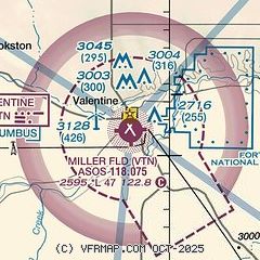
| Sectional chart |
|---|
|
| Airport distance calculator |
|---|
|
|
| Sunrise and sunset |
|---|
|
Times for 10-May-2026
| | Local
(UTC-5) | | Zulu
(UTC) |
|---|
| Morning civil twilight | | 05:54 | | 10:54 |
| Sunrise | | 06:26 | | 11:26 |
| Sunset | | 20:51 | | 01:51 |
| Evening civil twilight | | 21:23 | | 02:23 |
|
| Current date and time |
|---|
| Zulu (UTC) | 10-May-2026 10:12:37 |
|---|
| Local (UTC-5) | 10-May-2026 05:12:37 |
|---|
|
| TAF |
|---|
| KVTN | 100523Z 1006/1106 26007KT P6SM SCT100 FM101600 31009KT P6SM SCT070 FM101900 35007KT P6SM SCT100 FM110000 05008KT P6SM FEW250 FM110200 10007KT P6SM SKC
|
|
| NOTAMs |
|---|
NOTAMs are issued by the DoD/FAA and will open in a separate window not controlled by AirNav.
|
|

