FAA INFORMATION EFFECTIVE 14 MAY 2026
Location
| FAA Identifier: | XNO |
| Lat/Long: | 33-36-34.1674N 081-04-52.2382W
33-36.569457N 081-04.870637W
33.6094909,-81.0811773
(estimated) |
| Elevation: | 321.1 ft. / 98 m (estimated) |
| Variation: | 07W (2015) |
| Time zone: | UTC -4 (UTC -5 during Standard Time) |
| Zip code: | 29112 |
Airport Operations
| Airport use: | Private use. Permission required prior to landing |
| Activation date: | 04/1943 |
| Control tower: | no |
| ARTCC: | JACKSONVILLE CENTER |
| FSS: | ANDERSON FLIGHT SERVICE STATION |
| NOTAMs facility: | CHS (NOTAM-D service available) |
| Attendance: | MON-THU 1430-0900, ALL FRI 1430-2100, ALL SAT-SUN CLSD
Z++.
Z++.
CLSD FED HOLIDAYS. |
| Pattern altitude: | TPA: RECTANGULAR 979 FT AGL / 1300 FT MSL, OVHD 1479 FT AGL / 1800 FT MSL. |
| Wind indicator: | no |
| Segmented circle: | no |
| Lights: | ACTVT HIRL RWY 06/24 - 120.475. |
| Beacon: | white-green (lighted land airport)
ROTG BCN OFF DUR LGT OUT TRNG. |
Airport Communications
| WX ASOS at OGB (14 nm SE): | 118.525 (803-536-3901) |
| WX ASOS at CAE (20 nm N): | PHONE 803-369-6879 |
Nearby radio navigation aids
| VOR radial/distance | | VOR name | | Freq | | Var |
|---|
| CAEr187/14.9 | | COLUMBIA VORTAC | | 114.70 | | 02W |
| MMTr224/23.4 | | MC ENTIRE VORTAC | | 113.20 | | 08W |
| ALDr017/(37.4) | | ALLENDALE VOR | | 116.70 | | 01W |
| NDB name | | Hdg/Dist | | Freq | | Var | | ID |
|---|
| AIKEN | | 101/29.9 | | 347 | | 06W | | AIK | .- .. -.- |
Airport Services
| Airframe service: | NONE |
| Powerplant service: | NONE |
| Bottled oxygen: | NONE |
| Bulk oxygen: | NONE |
Runway Information
Runway 6/24
| Dimensions: | 10003 x 150 ft. / 3049 x 46 m |
| Surface: | asphalt |
| Weight bearing capacity: | |
| Runway edge lights: | high intensity |
| RUNWAY 6 | | RUNWAY 24 |
| Latitude: | 33-36.051517N | | 33-37.030017N |
| Longitude: | 081-05.828883W | | 081-04.241983W |
| Elevation: | 266.0 ft. | | 316.0 ft. |
| Traffic pattern: | left | | left |
| Displaced threshold: | 1000 ft. | | 1004 ft. |
| Declared distances: | TORA:8999 TODA:8999 ASDA:10003 LDA:9003 | | TORA:9003 TODA:9003 ASDA:10003 LDA:8999 |
| Touchdown point: | yes, no lights | | yes, no lights |
Runway 51/231
| Dimensions: | 3500 x 90 ft. / 1067 x 27 m |
| Surface: | concrete |
| Weight bearing capacity: | |
| RUNWAY 51 | | RUNWAY 231 |
| Latitude: | 33-36.442400N | | 33-36.859950N |
| Longitude: | 081-04.636700W | | 081-04.160583W |
| Elevation: | 292.7 ft. | | 321.1 ft. |
| Traffic pattern: | left | | left |
| Touchdown point: | yes, no lights | | yes, no lights |
Airport Ownership and Management from official FAA records
| Ownership: | U.S. Air Force |
| Owner: | USAF
JB CHARLESTON
CHARLESTON AFB, SC 29404
Phone 843-963-3028 |
| Manager: | 437 OSS BASE OPERATIONS
NORTH AF AUX
NORTH, SC 29112
Phone 843-963-3028 |
Additional Remarks
| - | REMARKS-RSTD TO OPR RSTD DUR BIRD WATCH COND MOD (TKOF OR LDG PERMS ONLY WHEN DEP/ARR RTE AVOID IDENT BIRD ACT, NO LCL IFR/VFR TFC PAT ATC) AND SEVERE (TKOF AND LDG PROH WO OG/GC APVL), CTC LZ/DZ OPS FAC FOR CURRENT BIRD WATCH COND. MIN 2 WK PRIOR COORD RQR FOR ALL USERS. |
| - | NS ABTMT: OVFT OF NORTH, SC PROH. |
| - | RSTD: TWY DELTA CLSD DURING BOX-IN-ONE OPS TO ALZ RWY 23. |
| - | RWY COND CODE (RWYCC) NOT RPTD. |
| - | MISC: AN/FMQ-19 AUTOMATED OBERSVING SYS IN USE, NOT AUGMENTED BY HUMAN OBSN. PMSV RDO UNAVBL. PMSV/PHONE PATCH AVBL THRU 628 CP DSN 673-8400 C843-963-8400. MIL WX ADVSY/WNG/FCST UPDATES AVBL O/R VIA 437OSSS/OSW DSN 673-3016 C843-963-3016 DUR OPR HR 1100-0100Z++ MON-THU AND 100-2200Z++ FRI; CLSD WKEND, HOL, AND DOWN DAYS. MSN WX SPT FOR AIRCREW AVBL VIA THE 26 OWS/BARKSDALE AFB, DSN 331-2651 OR C318-529-2651 DUR MIL WX FLT CLOSURE HR. |
| - | CAUTION: ALZ RWY 05/23 NO DIST MKR PANELS. |
| - | CAUTION: MIL NVD OPS MAY BE CONDUCTED IN VCNTY OF AFLD ANYTIME BTN SS AND SR. |
| - | MISC: IF UNABLE TO CTC XNO LZ/DZ OPS FACILITY ON UHF/VHF CTC VIA FONE C843-670-6664. |
| - | REMARKS-RSTD - ALL AIRCREWS WILL CTC LZ/DZ ON 120.475/ 235.775 PRIOR TO 5 NM FROM NORTH AF AUX. LZ/DZ OPS FAC OPR 1430-0900Z ++ MON-THU; OPR 1430-2100++ FRI. CLSD SAT-SUN & FED HOL. |
| - | COMM/NAV/WEATHER REMARKS: ASOS 118.525 LCTD AT ORANGEBURG MUNI (KOGB). |
| - | LZ/DZ OPS FAC LTD TO ADVSY SVC ONLY, NO ATC SVCS PRVDD, AIRCREWS WILL CTC COLUMBIA APP TO REQ/ACTVT IFR CLNC. |
| - | CAUTION: AERODROME ARFF AT REDUCED LVL OF SVC, USAF CAT 4 DUE TO VEH SHORTAGE, 6800 GAL AVBL. |
| - | FOR CD CTC COLUMBIA APCH AT 803-822-5242 OR 803-822-5040. |
| - | SEE FLIP AP/1 SUPPLRY ARPT RMK. |
| - | CAUTION: INTS HVY MIL JET AND MISC ACFT EXCTNG NMRS CARGO AND PERS DROPS, HI-SPEED LO-LEVEL FORMATION FLT, AND AIRLAND OPR. RWY 06-24 NW TREE LINE 750 FT FR RWY CNTRLN. |
| - | CAUTION: RWY 06-24 LARGE DITCH 350 FT FR RWY CNTRLN AT MIDFIELD ON NW SIDE RWY. INTS GND TRNG ON RSVN. RWY 05-23 USED AS ASSAULT LDG ZONE (ALZ) 3500 FT X 90 FT. |
| - | RSTD: POC IS CHARLESTON AFB, 437 OSS/OSO, DSN 673-5554, C843-963-5554. ALL AIRCREWS WILL CTC NORTH DZ ON 120.75 OR 235.775 PRIOR TO 5 NM TO NORTH AF AUX. THIS ASP IS SUBJ TO BE RSTD BY NOTAM. RWY 06-24, NO 180 DEG STAR TURNS ON ASPH, CONDUCT ALL TURNS ON CONC ENDS. |
| - | MISC: ALZ RWY 05-23 AND 06-24 GROOVED. LZ/DZ OPS FACILITY LTD TO ADVSY SVC ONLY, NO ATC SVCS PRVDD, AIRCREWS WILL CTC COLUMBIA APP TO REQ/ACTVT IFR CLNC. |
Instrument Procedures
NOTE: All procedures below are presented as PDF files. If you need a reader for these files, you should download the free Adobe Reader.NOT FOR NAVIGATION. Please procure official charts for flight.
FAA instrument procedures published for use from 14 May 2026 at 0901Z to 11 June 2026 at 0900Z.
IAPs - Instrument Approach Procedures |
|---|
| RNAV (GPS) RWY 06 | |
download (67KB) |
| RNAV (GPS) RWY 24 | |
download (64KB) |
| VOR OR TACAN-A | |
download (105KB) |
| NOTE: Special Take-Off Minimums/Departure Procedures apply | |
download (178KB) |
Other nearby airports with instrument procedures:
6J0 - Lexington County Airport (14 nm NW)
KOGB - Orangeburg Municipal Airport (14 nm SE)
99N - Bamberg County Airport (18 nm S)
KCAE - Columbia Metro Airport (20 nm N)
KCUB - Jim Hamilton L B Owens Airport (22 nm N)
|
|

Road maps at:
MapQuest
Bing
Google
| Aerial photo |
|---|

|
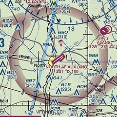
| Sectional chart |
|---|
|
| Airport distance calculator |
|---|
|
|
| Sunrise and sunset |
|---|
|
Times for 30-May-2026
| | Local
(UTC-4) | | Zulu
(UTC) |
|---|
| Morning civil twilight | | 05:48 | | 09:48 |
| Sunrise | | 06:17 | | 10:17 |
| Sunset | | 20:27 | | 00:27 |
| Evening civil twilight | | 20:55 | | 00:55 |
|
| Current date and time |
|---|
| Zulu (UTC) | 30-May-2026 04:47:41 |
|---|
| Local (UTC-4) | 30-May-2026 00:47:41 |
|---|
|
| METAR |
|---|
| KXNO | 300355Z AUTO 19003KT 10SM FEW180 24/21 A2993 RMK AO2 SLP135 T02420213 $
|
KOGB
14nm SE | 300353Z AUTO 18003KT 10SM CLR 23/21 A2996 RMK AO2 SLP142 T02330211 TSNO
|
KCAE
20nm N | 300356Z 20005KT 10SM OVC130 25/21 A2994 RMK AO2 SLP135 T02500211 $
|
|
| TAF |
|---|
KOGB
14nm SE | 300213Z 3002/3024 VRB05KT P6SM SCT025 BKN120 FM300600 VRB03KT P6SM VCSH SCT025 OVC040 PROB30 3006/3012 6SM -SHRA BKN025
|
KCAE
20nm N | 300213Z 3002/3024 VRB03KT P6SM SCT025 BKN120 FM300800 VRB03KT P6SM VCSH SCT025 OVC040
|
|
| NOTAMs |
|---|
NOTAMs are issued by the DoD/FAA and will open in a separate window not controlled by AirNav.
|
|

