FAA INFORMATION EFFECTIVE 12 JUNE 2025
Location
| FAA Identifier: | LGF |
| Lat/Long: | 32-51-52.4900N 114-23-34.7100W
32-51.874833N 114-23.578500W
32.8645806,-114.3929750
(estimated) |
| Elevation: | 432.8 ft. / 131.9 m (surveyed) |
| Variation: | 13E (1980) |
| From city: | 12 miles NE of YUMA PROVING GROUND (YUMA), AZ |
| Time zone: | UTC -7 (year round; does not observe DST) |
| Zip code: | 85365 |
Airport Operations
| Airport use: | Private use. Permission required prior to landing |
| Control tower: | yes |
| ARTCC: | LOS ANGELES CENTER |
| FSS: | PRESCOTT FLIGHT SERVICE STATION |
| NOTAMs facility: | PRC (NOTAM-D service available) |
| Attendance: | MON-FRI 0600-1600, CLSD HOL |
| Pattern altitude: | TFC PAT: RGT TFC RWY 06 AND 36. F/W 1700 FT MSL. R/W 1100 FT MSL. NO RGT TFC RWY 18. |
| Wind indicator: | yes |
| Segmented circle: | no |
| Lights: | ACTVT MIRL RWY 18/36 - 126.2. PAPI RWY 18 & 36 OPR CONSLY DURG OPS; OTR TIME ON REQ - BASE OPS. |
| Beacon: | white-green (lighted land airport)
Operates sunset to sunrise. |
Airport Communications
| CTAF: | 126.2 |
| ATIS: | 128.225 |
| LAGUNA GROUND: | 121.8 229.4 [0600-1600 MON-FRI, CLSD HOL, O/T BY NOTAM.] |
| LAGUNA TOWER: | 126.2 242.175 [0600-1600 MON-FRI, CLSD HOL, O/T BY NOTAM.] |
| RANGE CTL: | 119.0 248.4 |
- APCH CTL SVC PRVVD BY YUMA CERAP ON 124.7/371.975 (YUMA RCAG). DEP CTL SVC PRRVD BY YUMA CERAP ON 125.55/282.325 (YUMA/A RCAG).
Nearby radio navigation aids
| VOR radial/distance | | VOR name | | Freq | | Var |
|---|
| BZAr047/12.1 | | BARD VORTAC | | 116.80 | | 14E |
Airport Services
| Fuel available: | 100LL |
| Oil available: | CTAF 242.175 |
Runway Information
Runway 18/36
| Dimensions: | 6142 x 151 ft. / 1872 x 46 m |
| Surface: | asphalt |
| Weight bearing capacity: | |
| Runway edge lights: | medium intensity |
| RUNWAY 18 | | RUNWAY 36 |
| Latitude: | 32-52.535583N | | 32-51.540983N |
| Longitude: | 114-23.564233W | | 114-23.790833W |
| Elevation: | 409.6 ft. | | 361.0 ft. |
| Traffic pattern: | left | | right |
| Markings: | none, in poor condition | | none, in poor condition |
| Visual slope indicator: | 4-light PAPI on left (3.00 degrees glide path) | | 4-light PAPI on left (3.00 degrees glide path) |
| Touchdown point: | yes, no lights | | yes, no lights |
Runway 6/24
| Dimensions: | 6043 x 100 ft. / 1842 x 30 m |
| Surface: | asphalt |
| Weight bearing capacity: | |
| RUNWAY 6 | | RUNWAY 24 |
| Latitude: | 32-51.587900N | | 32-51.829533N |
| Longitude: | 114-24.050583W | | 114-22.905117W |
| Elevation: | 366.6 ft. | | 424.9 ft. |
| Traffic pattern: | right | | left |
| Markings: | basic, in fair condition | | basic, in fair condition |
| Touchdown point: | yes, no lights | | yes, no lights |
Helipad H1
| Dimensions: | 40 x 40 ft. / 12 x 12 m |
| Surface: | asphalt |
| Latitude: | 32-52.113000N | | |
| Longitude: | 114-23.761333W | | |
| Elevation: | 365.0 ft. | | |
| Traffic pattern: | left | | left |
Helipad H2
| Dimensions: | 40 x 40 ft. / 12 x 12 m |
| Surface: | asphalt |
| Latitude: | 32-52.045000N | | |
| Longitude: | 114-23.776667W | | |
| Elevation: | 360.0 ft. | | |
| Traffic pattern: | left | | left |
Helipad H3
| Dimensions: | 40 x 40 ft. / 12 x 12 m |
| Surface: | asphalt |
| Latitude: | 32-51.992000N | | |
| Longitude: | 114-23.788667W | | |
| Elevation: | 362.0 ft. | | |
| Traffic pattern: | left | | left |
Airport Ownership and Management from official FAA records
| Ownership: | U.S. Army |
| Owner: | US ARMY AERONAUTICAL SVCS AGENCY
FT BELVOIR, VA 22060 |
| Manager: | Phone 928-328-5028 |
Additional Remarks
| - | CTN: WILDLIFE & COYOTES ON & INVOF ARPT; SPCLY AT NGT. |
| - | CTN: OPS ON CIBOLA RANGE 1 NM. PAJA INVOF 5 NM. |
| - | OPS 0600-1600 MON-FRI; CLSD HOL; OTR TIME BY NOTAM. |
| - | RSTD: OFFL BUS ONLY. RSTD AREA 4 NM E. OVFT OF HOUSING AREA 3 NM SW NA. TSNT 24 HR PPR - D899-2014/2241, C928-328-2014/2241. |
| - | MISC: LATE ARR - BASE OPS D899-2014/2241, 928-328-2014/2241. |
| - | SVC: FUEL, LOX SVC AVBL - BASE OPS. |
| - | RSTD: CLSD FLD OPS PPR - BASE OPS OR LAGUNA OPS. |
| - | CTN: UAS OPS FM LAGUNA AAF WHEN RSTD ASP ACTV; CTC LAGUNA ATCT PRIOR TO ENTRY. |
| - | FOR CD CTC YUMA CERAP CD AT 982-269-9569. |
| - | CTN: C-130 & LRGR TURN AROUND ON RWY NA EXC PRIOR APVL FOR EMERG OR CONGESTION. |
| - | JASU-5(GPU) 3(59B2-1B). |
| - | FUEL: 100LL, F24 AVBL 1340-2400Z MON-FRI; CLSD HOL. POL AVBL WITH 24 HR PPR FOR TSNT. CONTR FUEL - AVCARD ONLY. |
| - | TRAN ALERT: LTD MAINT SVC AVBL. |
Instrument Procedures
NOTE: All procedures below are presented as PDF files. If you need a reader for these files, you should download the free Adobe Reader.NOT FOR NAVIGATION. Please procure official charts for flight.
FAA instrument procedures published for use from 12 June 2025 at 0901Z to 10 July 2025 at 0900z.
IAPs - Instrument Approach Procedures |
|---|
| RNAV (GPS) RWY 06 **CHANGED** | |
download (125KB) |
| RNAV (GPS) RWY 18 **CHANGED** | |
download (129KB) |
| VOR RWY 06 **CHANGED** | |
download (143KB) |
| NOTE: Special Take-Off Minimums/Departure Procedures apply **CHANGED** | |
download (415KB) |
Other nearby airports with instrument procedures:
KNYL - Yuma Marine Corps Air Station/Yuma International Airport (16 nm SW)
KBLH - Blythe Airport (48 nm N)
KBWC - Brawley Municipal Airport (57 nm W)
KCLR - Cliff Hatfield Memorial Airport (59 nm W)
KIPL - Imperial County Airport (60 nm W)
|
|

Road maps at:
MapQuest
Bing
Google
| Aerial photo |
|---|
WARNING: Photo may not be current or correct

Do you have a better or more recent aerial photo of Laguna Army Airfield (Yuma Proving Ground) that you would like to share? If so, please send us your photo.
|
| Sectional chart |
|---|
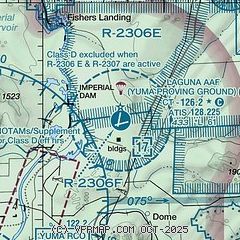
|
 Download PDF
of official airport diagram from the FAA
| Airport distance calculator |
|---|
|
|
| Sunrise and sunset |
|---|
|
Times for 29-Jun-2025
| | Local
(UTC-7) | | Zulu
(UTC) |
|---|
| Morning civil twilight | | 05:05 | | 12:05 |
| Sunrise | | 05:33 | | 12:33 |
| Sunset | | 19:49 | | 02:49 |
| Evening civil twilight | | 20:17 | | 03:17 |
|
| Current date and time |
|---|
| Zulu (UTC) | 29-Jun-2025 10:14:50 |
|---|
| Local (UTC-7) | 29-Jun-2025 03:14:50 |
|---|
|
| METAR |
|---|
| KLGF | 290955Z AUTO 00000KT 10SM CLR 31/09 A2978 RMK AO2 SLP079 T03080091 $
|
KNYL
18nm SW | 290957Z AUTO 20004KT 10SM CLR 29/11 A2979 RMK AO2 SLP083 T02890111
|
|
| TAF |
|---|
KNYL
18nm SW | 2903/3003 26004KT 9999 SKC QNH2975INS FM290500 26004KT 9999 SKC QNH2978INS BECMG 2916/2918 30006KT 9999 SKC QNH2982INS TX43/3001Z TN26/2909Z
|
|
| NOTAMs |
|---|
NOTAMs are issued by the DoD/FAA and will open in a separate window not controlled by AirNav.
|
|


