FAA INFORMATION EFFECTIVE 22 JANUARY 2026
Location
| FAA Identifier: | LRD |
| Lat/Long: | 27-32-39.1000N 099-27-41.7000W
27-32.651667N 099-27.695000W
27.5441944,-99.4615833
(estimated) |
| Elevation: | 508 ft. / 154.8 m (surveyed) |
| Variation: | 05E (2020) |
| From city: | 3 miles NE of LAREDO, TX |
| Time zone: | UTC -6 (UTC -5 during Daylight Saving Time) |
| Zip code: | 78041 |
Airport Operations
| Airport use: | Open to the public |
| Control tower: | yes |
| ARTCC: | HOUSTON CENTER |
| FSS: | SAN ANGELO FLIGHT SERVICE STATION |
| NOTAMs facility: | LRD (NOTAM-D service available) |
| Attendance: | CONTINUOUS |
| Wind indicator: | lighted |
| Segmented circle: | yes |
| Lights: | WHEN ATCT CLSD ACTVT MALSR RWY 18R - CTAF. MIRL RWY 14/32; HIRL RWYS 18L/36R & 18R/36L PRESET MED INTST. |
| Beacon: | white-green (lighted land airport)
Operates sunset to sunrise. |
| Fire and rescue: | ARFF index B |
| International operations: | international airport of entry |
Airport Communications
| CTAF: | 120.1 |
| UNICOM: | 122.95 |
| ATIS: | 125.775 |
| WX AWOS-3PT: | PHONE 956-712-8640 |
| LAREDO GROUND: | 121.8 [0600-2400] |
| LAREDO TOWER: | 120.1 257.9 [0600-2400] |
| EMERG: | 243.0 |
- APCH/DEP CTL SVC PRVDD BY HOUSTON ARTCC (ZHU) ON FREQS 127.8/307.2 (LAREDO RCAG).
Nearby radio navigation aids
| VOR radial/distance | | VOR name | | Freq | | Var |
|---|
| LRDr320/4.6 | | LAREDO VORTAC | | 117.40 | | 09E |
Airport Services
| Fuel available: | 100LL JET-A
100LL:JP4 FUEL AVBL. |
| Parking: | hangars and tiedowns |
| Powerplant service: | MAJOR |
| Bottled oxygen: | LOW |
| Bulk oxygen: | LOW |
Runway Information
Runway 18R/36L
| Dimensions: | 8743 x 150 ft. / 2665 x 46 m |
| Surface: | concrete/grooved, in good condition |
| Weight bearing capacity: | | Single wheel: | 90.0 | | Double wheel: | 190.0 | | Double tandem: | 415.0 | | Dual double tandem: | 820.0 |
|
| Runway edge lights: | high intensity |
| RUNWAY 18R | | RUNWAY 36L |
| Latitude: | 27-33.389468N | | 27-31.948028N |
| Longitude: | 099-27.745213W | | 099-27.817415W |
| Elevation: | 503.7 ft. | | 483.7 ft. |
| Traffic pattern: | left | | right |
| Runway heading: | 178 magnetic, 183 true | | 358 magnetic, 003 true |
| Displaced threshold: | no | | 120 ft. |
| Declared distances: | TORA:8743 TODA:8743 ASDA:8743 LDA:8743 | | TORA:8743 TODA:8743 ASDA:8743 LDA:8623 |
| Markings: | precision, in good condition | | precision, in good condition |
| Visual slope indicator: | 4-light PAPI on left (3.00 degrees glide path) | | 4-light PAPI on left (3.00 degrees glide path) |
| Approach lights: | MALSR: 1,400 foot medium intensity approach lighting system with runway alignment indicator lights | | |
| Runway end identifier lights: | | | no |
| Touchdown point: | yes, no lights | | yes, no lights |
| Instrument approach: | ILS/DME | | |
Runway 18L/36R
| Dimensions: | 8236 x 150 ft. / 2510 x 46 m |
| Surface: | concrete/grooved, in good condition |
| Weight bearing capacity: | | Single wheel: | 90.0 | | Double wheel: | 190.0 | | Double tandem: | 360.0 |
|
| Runway edge lights: | high intensity |
| RUNWAY 18L | | RUNWAY 36R |
| Latitude: | 27-33.382112N | | 27-32.024245N |
| Longitude: | 099-27.559980W | | 099-27.628223W |
| Elevation: | 499.2 ft. | | 474.2 ft. |
| Traffic pattern: | left | | right |
| Runway heading: | 178 magnetic, 183 true | | 358 magnetic, 003 true |
| Declared distances: | TORA:8236 TODA:8236 ASDA:8236 LDA:8236 | | TORA:8236 TODA:8236 ASDA:8236 LDA:8236 |
| Markings: | nonprecision, in good condition | | nonprecision, in good condition |
| Visual slope indicator: | 4-light PAPI on left (3.00 degrees glide path) | | |
| Touchdown point: | yes, no lights | | yes, no lights |
Runway 14/32
| Dimensions: | 5927 x 150 ft. / 1807 x 46 m |
| Surface: | concrete, in good condition |
| Weight bearing capacity: | | Single wheel: | 50.0 | | Double wheel: | 60.0 | | Double tandem: | 125.0 |
|
| Runway edge lights: | medium intensity |
| Operational restrictions: | RWY 14/32 NOT AVBL FOR PART 121/PART 380 OPS WITH SKED PAX CARRYING OPS MORE THAN 9 PAX SEATS AND NON-SKED PAX CARRYING OPS MORE THAN 30 PAX SEATS. |
| RUNWAY 14 | | RUNWAY 32 |
| Latitude: | 27-32.967080N | | 27-32.143917N |
| Longitude: | 099-28.003737W | | 099-27.411133W |
| Elevation: | 505.4 ft. | | 467.4 ft. |
| Traffic pattern: | left | | right |
| Runway heading: | 142 magnetic, 147 true | | 322 magnetic, 327 true |
| Declared distances: | TORA:5927 TODA:5927 ASDA:5927 LDA:5927 | | TORA:5927 TODA:5927 ASDA:5927 LDA:5927 |
| Markings: | nonprecision, in good condition | | nonprecision, in good condition |
| Visual slope indicator: | 4-box VASI on left (3.00 degrees glide path) | | 4-box VASI on left (3.00 degrees glide path) |
| Touchdown point: | yes, no lights | | yes, no lights |
| Obstructions: | none | | 12 ft. road, 201 ft. from runway, 250 ft. right of centerline |
Airport Ownership and Management from official FAA records
| Ownership: | Publicly-owned |
| Owner: | CITY OF LAREDO
PO BOX 579
LAREDO, TX 78041
Phone 956-791-7300 |
| Manager: | GILBERTO SANCHEZ
5210 BOB BULLOCK LOOP
LAREDO, TX 78041
Phone 956-795-2000 |
Additional Remarks
| A39-18R/36L | PCR VALUE: 684/R/D/W/T |
| A39-18L/36R | PCR VALUE: 600/R/D/W/T |
| A39-14/32 | PCR VALUE: 98/R/D/W/T |
| E60-18R | ENGINEERED MATERIALS ARRESTING SYSTEM (EMAS) 363 FT IN LENGTH BY 170 FT IN WIDTH LCTD AT THE DER 18R. |
| - | FEDERAL INSPECTION STATION IS LCTD ON THE WEST GENERAL AVIATION/CARGO APRON. |
| - | FOR CD IF UNA TO CTC ON FSS FREQ, CTC HOUSTON ARTCC AT 281-230-5622. |
| - | BIRDS ON AND INVOF ARPT. |
| - | LNDG FEE ASSESSED FOR ALL ACFT EXC FEDERAL, MIL AND BASED ACFT. |
| - | FEDERAL INSPECTION STATION FEE. |
| - | RWY 14/32 RSTRD TO ACFT LESS THAN 60000 LBS DTW. |
| - | TWY C CLSD BTN RWY 18L/36R & RWY 18R INDEFLY. |
Instrument Procedures
NOTE: All procedures below are presented as PDF files. If you need a reader for these files, you should download the free Adobe Reader.NOT FOR NAVIGATION. Please procure official charts for flight.
FAA instrument procedures published for use from 22 January 2026 at 0901Z to 19 February 2026 at 0900z.
IAPs - Instrument Approach Procedures |
|---|
| ILS OR LOC RWY 18R | |
download (298KB) |
| RNAV (GPS) RWY 14 | |
download (207KB) |
| RNAV (GPS) RWY 18L | |
download (225KB) |
| RNAV (GPS) RWY 18R | |
download (259KB) |
| RNAV (GPS) RWY 32 | |
download (254KB) |
| RNAV (GPS) RWY 36L | |
download (248KB) |
| LOC BC RWY 36L | |
download (235KB) |
| VOR OR TACAN RWY 14 | |
download (223KB) |
| VOR OR TACAN RWY 32 | |
download (218KB) |
| NOTE: Special Alternate Minimums apply | |
download (52KB) |
| NOTE: Special Take-Off Minimums/Departure Procedures apply | |
download (154KB) |
Other nearby airports with instrument procedures:
KHBV - Jim Hogg County Airport (40 nm E)
KCOT - Cotulla-La Salle County Airport (56 nm N)
KCZT - Dimmit County Airport (62 nm N)
KBKS - Brooks County Airport (74 nm E)
KIKG - Kleberg County Airport (76 nm E)
|
|

Road maps at:
MapQuest
Bing
Google
| Aerial photo |
|---|
WARNING: Photo may not be current or correct

Do you have a better or more recent aerial photo of Laredo International Airport that you would like to share? If so, please send us your photo.
|
| Sectional chart |
|---|
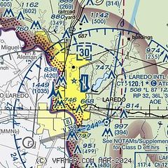
|
CAUTION: Diagram may not be current
 Download PDF
of official airport diagram from the FAA
| Airport distance calculator |
|---|
|
|
| Sunrise and sunset |
|---|
|
Times for 02-Feb-2026
| | Local
(UTC-6) | | Zulu
(UTC) |
|---|
| Morning civil twilight | | 07:00 | | 13:00 |
| Sunrise | | 07:25 | | 13:25 |
| Sunset | | 18:19 | | 00:19 |
| Evening civil twilight | | 18:43 | | 00:43 |
|
| Current date and time |
|---|
| Zulu (UTC) | 02-Feb-2026 15:58:33 |
|---|
| Local (UTC-6) | 02-Feb-2026 09:58:33 |
|---|
|
| METAR |
|---|
| KLRD | 021456Z 12005KT 10SM OVC034 13/09 A3030 RMK AO2 SLP263 T01280089 53006 $
|
MMNL
9nm SW | 021440Z 00000KT 7SM BKN030 BKN220 12/08 A3030 RMK SLP254 52004 992 8/502
|
|
| TAF |
|---|
| KLRD | 021121Z 0212/0312 13006KT P6SM SCT035 SCT250 TEMPO 0212/0216 BKN025 FM021800 15015G23KT P6SM BKN050 FM022300 14012KT P6SM BKN250 FM031000 15008KT P6SM SCT025 BKN250
|
MMNL
9nm SW | 020445Z 0206/0306 12010KT P6SM BKN040 TEMPO 0212/0215 2SM BR BKN010 FM021800 14015G25KT P6SM BKN040 FM022200 16012KT P6SM BKN070
|
|
| NOTAMs |
|---|
NOTAMs are issued by the DoD/FAA and will open in a separate window not controlled by AirNav.
|
|


