FAA INFORMATION EFFECTIVE 14 MAY 2026
Location
| FAA Identifier: | MEV |
| Lat/Long: | 39-00-01.8000N 119-45-04.0000W
39-00.030000N 119-45.066667W
39.0005000,-119.7511111
(estimated) |
| Elevation: | 4723.6 ft. / 1439.8 m (surveyed) |
| Variation: | 15E (2000) |
| From city: | 4 miles N of MINDEN, NV |
| Time zone: | UTC -7 (UTC -8 during Standard Time) |
| Zip code: | 89423 |
Airport Operations
| Airport use: | Open to the public |
| Activation date: | 12/1942 |
| Control tower: | no |
| ARTCC: | OAKLAND CENTER |
| FSS: | RENO FLIGHT SERVICE STATION |
| NOTAMs facility: | MEV (NOTAM-D service available) |
| Attendance: | MON-FRI 0730-1600 |
| Wind indicator: | lighted |
| Segmented circle: | yes |
| Lights: | ACTVT REIL RWY 16 & 34; VASI RWY 16 & 34; HIRL RWY 16/34 - CTAF. |
| Beacon: | white-green (lighted land airport)
Operates sunset to sunrise. |
Airport Communications
| CTAF/UNICOM: | 123.05 |
| WX AWOS-3PT: | 119.325 (775-782-6264) |
| NORCAL APPROACH: | 119.2 |
| NORCAL DEPARTURE: | 119.2 |
| CLEARANCE DELIVERY: | 133.25 |
| WX AWOS-3PT at CXP (12 nm N): | 119.925 (775-884-4708) |
| WX ASOS at TVL (13 nm SW): | 124.725 (530-573-5836) |
Nearby radio navigation aids
| VOR radial/distance | | VOR name | | Freq | | Var |
|---|
| SWRr098/26.4 | | PALISADES VOR/DME | | 113.20 | | 16E |
| FMGr172/32.2 | | MUSTANG VORTAC | | 117.90 | | 16E |
Airport Services
| Fuel available: | 100LL JET-A |
| Parking: | hangars and tiedowns |
| Airframe service: | MAJOR |
| Powerplant service: | MAJOR |
| Bottled oxygen: | HIGH |
Runway Information
Runway 16/34
| Dimensions: | 7399 x 100 ft. / 2255 x 30 m |
| Surface: | asphalt, in excellent condition |
| Weight bearing capacity: | | Single wheel: | 50.0 | | Double wheel: | 75.0 |
|
| Runway edge lights: | high intensity |
| RUNWAY 16 | | RUNWAY 34 |
| Latitude: | 39-00.688603N | | 38-59.470017N |
| Longitude: | 119-45.118780W | | 119-45.113030W |
| Elevation: | 4707.7 ft. | | 4717.2 ft. |
| Traffic pattern: | right | | left |
| Runway heading: | 165 magnetic, 180 true | | 345 magnetic, 360 true |
| Markings: | nonprecision, in good condition | | nonprecision, in good condition |
| Visual slope indicator: | 4-box VASI on right (3.00 degrees glide path) | | 4-box VASI on left (3.00 degrees glide path) |
| Runway end identifier lights: | yes | | yes |
| Touchdown point: | yes, no lights | | yes, no lights |
Runway 12/30
| Dimensions: | 5299 x 75 ft. / 1615 x 23 m |
| Surface: | asphalt, in good condition |
| Weight bearing capacity: | | Single wheel: | 50.0 | | Double wheel: | 75.0 |
|
| RUNWAY 12 | | RUNWAY 30 |
| Latitude: | 39-00.329320N | | 38-59.714447N |
| Longitude: | 119-45.512610W | | 119-44.718975W |
| Elevation: | 4700.2 ft. | | 4722.1 ft. |
| Traffic pattern: | right | | left |
| Runway heading: | 120 magnetic, 135 true | | 300 magnetic, 315 true |
| Markings: | basic, in good condition | | basic, in good condition |
| Runway end identifier lights: | no | | no |
| Touchdown point: | yes, no lights | | yes, no lights |
| Obstructions: | 60 ft. tree, 1430 ft. from runway, 30 ft. left of centerline, 20:1 slope to clear | | none |
Runway 12G/30G
| Dimensions: | 2050 x 60 ft. / 625 x 18 m |
| Surface: | dirt, in fair condition |
| Runway edge markings: | THR MKD WITH ORANGE & WHITE PANELS. |
| Operational restrictions: | RWY 30G LNDG ONLY; RWY 12G TKOF & LNDG NA. |
| RUNWAY 12G | | RUNWAY 30G |
| Latitude: | 38-59.994523N | | 38-59.756615N |
| Longitude: | 119-44.915485W | | 119-44.608490W |
| Elevation: | 4712.4 ft. | | 4723.6 ft. |
| Traffic pattern: | left | | left |
| Runway heading: | 120 magnetic, 135 true | | 300 magnetic, 315 true |
| Markings: | none | | |
| Runway end identifier lights: | no | | |
| Touchdown point: | yes, no lights | | yes, no lights |
Airport Ownership and Management from official FAA records
| Ownership: | Publicly-owned |
| Owner: | DOUGLAS COUNTY
P O BOX 218
MINDEN, NV 89423
Phone 775-782-9821 |
| Manager: | HEATHER MACDONNELL
1146 AIRPORT ROAD
MINDEN, NV 89423
Phone 775-782-9871 |
Additional Remarks
| A39-12/30 | PCR VALUE: 10/F/C/X/T |
| A39-16/34 | PCR VALUE: 40/F/C/X/T |
| A30A-34 | SAILPLANE PAT RT TFC. |
| A30A-30 | SAILPLANE PAT RT TFC. |
| - | GLIDER, ULTRALIGHT, SKYDIVING, SAILPLANE AND BALLOON ACT ON AND INVOF ARPT. |
| - | EMERG AFT 1700 - 775-782-5126. |
| - | SNOW REMOVAL DURG DALGT ONLY. |
| - | NOISE ABATEMENT PROC IN EFCT - 775-782-9871. |
| - | TREES 1,440 FT FROM APCH END RY 12. DITCH IN OBSTACLE FREE ZONE ADJ SW END TWY C. MEN & EQUIPMENT OCCASIONLY ON RWYS AND TWYS. |
| - | MOWERS INVOF ARPT & RWYS. |
| - | FOR CD CTC NORCAL APCH AT 916-361-6874. |
Instrument Procedures
NOTE: All procedures below are presented as PDF files. If you need a reader for these files, you should download the free Adobe Reader.NOT FOR NAVIGATION. Please procure official charts for flight.
FAA instrument procedures published for use from 14 May 2026 at 0901Z to 11 June 2026 at 0900Z.
IAPs - Instrument Approach Procedures |
|---|
| RNAV (GPS) RWY 16 | |
download (414KB) |
| RNAV (GPS) RWY 34 | |
download (734KB) |
| NOTE: Special Alternate Minimums apply | |
download (142KB) |
|
|---|
| MINDEN THREE (OBSTACLE) (RNAV) **NEW** | |
download (153KB) |
| NOTE: Special Take-Off Minimums/Departure Procedures apply **CHANGED** | |
download (388KB) |
Other nearby airports with instrument procedures:
KCXP - Carson City Airport (12 nm N)
KTVL - Lake Tahoe Airport (13 nm SW)
KTRK - Truckee-Tahoe Airport (26 nm NW)
O43 - Yerington Municipal Airport (28 nm E)
KRNO - Reno/Tahoe International Airport (30 nm N)
|
|

Road maps at:
MapQuest
Bing
Google
| Aerial photo |
|---|
WARNING: Photo may not be current or correct
 Photo courtesy of Pilot Getaways magazine
www.pilotgetaways.com/
Do you have a better or more recent aerial photo of Minden-Tahoe Airport that you would like to share? If so, please send us your photo.
|
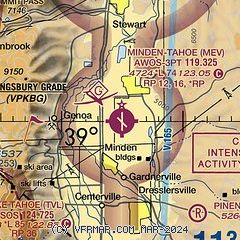
| Sectional chart |
|---|
|
CAUTION: Diagram may not be current

| Airport distance calculator |
|---|
|
|
| Sunrise and sunset |
|---|
|
Times for 10-Jun-2026
| | Local
(UTC-7) | | Zulu
(UTC) |
|---|
| Morning civil twilight | | 05:02 | | 12:02 |
| Sunrise | | 05:34 | | 12:34 |
| Sunset | | 20:23 | | 03:23 |
| Evening civil twilight | | 20:55 | | 03:55 |
|
| Current date and time |
|---|
| Zulu (UTC) | 10-Jun-2026 13:34:57 |
|---|
| Local (UTC-7) | 10-Jun-2026 06:34:57 |
|---|
|
| METAR |
|---|
| KMEV | 101305Z AUTO 36004KT 10SM CLR 05/M00 A3013 RMK AO2
|
KCXP
12nm N | 101315Z AUTO 00000KT 10SM CLR 11/03 A3015 RMK AO2
|
KTVL
13nm SW | 101253Z AUTO 00000KT 10SM CLR 02/M01 A3017 RMK AO2 SLP178 T00171011
|
|
| TAF |
|---|
| KMEV | 101120Z 1012/1112 VRB05KT P6SM SKC FM101900 32011G18KT P6SM SKC FM110600 VRB05KT P6SM SKC
|
KCXP
12nm N | 101120Z 1012/1112 VRB05KT P6SM SKC FM101900 36016G25KT P6SM SKC FM110800 VRB05KT P6SM SKC
|
KTVL
13nm SW | 101120Z 1012/1112 VRB04KT P6SM SKC FM101700 02007KT P6SM SKC FM110200 VRB03KT P6SM SKC
|
|
| NOTAMs |
|---|
NOTAMs are issued by the DoD/FAA and will open in a separate window not controlled by AirNav.
|
|


