FAA INFORMATION EFFECTIVE 19 FEBRUARY 2026
Location
| FAA Identifier: | MHL |
| Lat/Long: | 39-05-43.7220N 093-12-10.7990W
39-05.728700N 093-12.179983W
39.0954783,-93.2029997
(estimated) |
| Elevation: | 778.9 ft. / 237.4 m (surveyed) |
| Variation: | 03E (2000) |
| From city: | 2 miles S of MARSHALL, MO |
| Time zone: | UTC -6 (UTC -5 during Daylight Saving Time) |
| Zip code: | 65340 |
Airport Operations
| Airport use: | Open to the public |
| Activation date: | 05/1941 |
| Control tower: | no |
| ARTCC: | KANSAS CITY CENTER |
| FSS: | COLUMBIA FLIGHT SERVICE STATION |
| NOTAMs facility: | COU (NOTAM-D service available) |
| Attendance: | APR-SEP 0700-1800, OCT-MAR 0700-1700 |
| Wind indicator: | lighted |
| Segmented circle: | yes |
| Lights: | ACTVT MIRL RY 18/36; PAPI RYS 18 & 36 AND REIL RY 36- CTAF. |
| Beacon: | white-green (lighted land airport)
Operates sunset to sunrise. |
Airport Communications
| CTAF/UNICOM: | 122.8 |
| WX AWOS-3PT: | 118.675 (660-886-9130) |
| WHITEMAN APPROACH: | 127.45 [OPR 1300-0500Z++ MON-FRI; 1400-2300Z++ SAT-SUN; CLSD HOL.] |
| WHITEMAN DEPARTURE: | 125.925 [OPR 1300-0500Z++ MON-FRI; 1400-2300Z++ SAT-SUN; CLSD HOL.] |
- APCH/DEP SVC PRVDD BY KANSAS CITY ARTCC ON FREQS 135.575/323.15 (KNOB NOSTER RCAG) WHEN WHITEMAN APCH CTL CLSD.
Airport Services
| Fuel available: | 100LL JET-A1+
100LL:100LL AND JET A1+ SELF SERVICE AVBL 24 HRS. |
| Parking: | tiedowns |
| Airframe service: | MINOR |
| Powerplant service: | MINOR |
| Bottled oxygen: | NONE |
| Bulk oxygen: | NONE |
Runway Information
Runway 18/36
| Dimensions: | 5005 x 75 ft. / 1526 x 23 m |
| Surface: | concrete, in excellent condition |
| Weight bearing capacity: | | Single wheel: | 30.0 | | Double wheel: | 42.0 |
|
| Runway edge lights: | medium intensity |
| RUNWAY 18 | | RUNWAY 36 |
| Latitude: | 39-06.115505N | | 39-05.291173N |
| Longitude: | 093-12.019830W | | 093-12.037615W |
| Elevation: | 770.4 ft. | | 778.9 ft. |
| Traffic pattern: | left | | left |
| Runway heading: | 178 magnetic, 181 true | | 358 magnetic, 001 true |
| Displaced threshold: | 200 ft. | | no |
| Markings: | nonprecision, in good condition | | nonprecision, in good condition |
| Visual slope indicator: | 4-light PAPI on left (3.05 degrees glide path) | | 4-light PAPI on left (3.04 degrees glide path) |
| Runway end identifier lights: | no | | yes |
| Touchdown point: | yes, no lights | | yes, no lights |
| Obstructions: | 61 ft. trees, 1085 ft. from runway, 375 ft. left and right of centerline, 14:1 slope to clear
RWY 18 APCH SLOPE 22:1 TO DSPLCD THR. | | none |
Runway 9/27
| Dimensions: | 3303 x 150 ft. / 1007 x 46 m |
| Surface: | turf, in excellent condition |
| Runway edge markings: | RY 09/27 MKD WITH LARGE YELLOW CONES. |
| RUNWAY 9 | | RUNWAY 27 |
| Latitude: | 39-05.794282N | | 39-05.739977N |
| Longitude: | 093-12.756557W | | 093-12.061787W |
| Elevation: | 749.8 ft. | | 777.9 ft. |
| Traffic pattern: | right | | left |
| Runway heading: | 093 magnetic, 096 true | | 273 magnetic, 276 true |
| Markings: | none, in fair condition | | none, in fair condition |
| Touchdown point: | yes, no lights | | yes, no lights |
Airport Ownership and Management from official FAA records
| Ownership: | Publicly-owned |
| Owner: | CITY OF MARSHALL
214 N LAFAYETTE
MARSHALL, MO 65340
Phone 660-886-2226 |
| Manager: | MUNI SERVICE DEPT
1277 S. ODELL
MARSHALL, MO 65340
Phone 660-886-9855 |
Additional Remarks
| - | HVY SEASONAL AG SPRAY ACFT OPNS ON & INVOF ARPT. |
| - | FOR CD CTC WHITEMAN APCH AT 660-687-3132. WHEN WHITEMAN APCH IS CLSD, CTC KANSAS CITY ARTCC AT 913-254-8508. |
Instrument Procedures
NOTE: All procedures below are presented as PDF files. If you need a reader for these files, you should download the free Adobe Reader.NOT FOR NAVIGATION. Please procure official charts for flight.
FAA instrument procedures published for use from 19 February 2026 at 0901Z to 19 March 2026 at 0900Z.
IAPs - Instrument Approach Procedures |
|---|
| RNAV (GPS) RWY 18 | |
download (215KB) |
| RNAV (GPS) RWY 36 | |
download (212KB) |
| NOTE: Special Take-Off Minimums/Departure Procedures apply | |
download (429KB) |
Other nearby airports with instrument procedures:
KHIG - Higginsville Industrial Municipal Airport (22 nm W)
KDMO - Sedalia Regional Airport (23 nm S)
KVER - Jesse Viertel Memorial Airport (26 nm E)
KSZL - Whiteman Air Force Base (27 nm SW)
KRCM - Skyhaven Airport (34 nm SW)
|
|

Road maps at:
MapQuest
Bing
Google
| Aerial photo |
|---|
WARNING: Photo may not be current or correct

Do you have a better or more recent aerial photo of Marshall Memorial Municipal Airport that you would like to share? If so, please send us your photo.
|
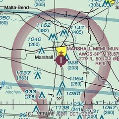
| Sectional chart |
|---|
|
| Airport distance calculator |
|---|
|
|
| Sunrise and sunset |
|---|
|
Times for 10-Mar-2026
| | Local
(UTC-5) | | Zulu
(UTC) |
|---|
| Morning civil twilight | | 07:06 | | 12:06 |
| Sunrise | | 07:33 | | 12:33 |
| Sunset | | 19:13 | | 00:13 |
| Evening civil twilight | | 19:40 | | 00:40 |
|
| Current date and time |
|---|
| Zulu (UTC) | 10-Mar-2026 14:03:21 |
|---|
| Local (UTC-5) | 10-Mar-2026 09:03:21 |
|---|
|
| METAR |
|---|
| KMHL | 101355Z AUTO 19009KT 10SM SCT014 18/17 A2977 RMK AO2
|
|
| TAF |
|---|
KSZL
27nm SW | 101100Z 1011/1117 18009KT 9999 SKC WS020/19045KT QNH2978INS TEMPO 1011/1013 8000 BR BECMG 1014/1015 20015G25KT 9999 BKN030 QNH2967INS BECMG 1103/1104 22015G25KT 4800 -TSRA OVC020CB QNH2963INS TEMPO 1104/1106 22025G35KT 3200 TSRA OVC010CB BECMG 1109/1110 30009KT 9000 -SHRA BR OVC010 QNH2963INS BECMG 1114/1115 34009KT 9999 NSW BKN030 QNH2980INS TX28/1022Z TN09/1111Z
|
|
| NOTAMs |
|---|
NOTAMs are issued by the DoD/FAA and will open in a separate window not controlled by AirNav.
|
|

