FAA INFORMATION EFFECTIVE 18 APRIL 2024
Location
| FAA Identifier: | NQI |
| Lat/Long: | 27-30-16.2520N 097-48-29.8420W
27-30.270867N 097-48.497367W
27.5045144,-97.8082894
(estimated) |
| Elevation: | 50 ft. / 15.2 m (surveyed) |
| Variation: | 04E (2010) |
| From city: | 3 miles E of KINGSVILLE, TX |
| Time zone: | UTC -5 (UTC -6 during Standard Time) |
| Zip code: | 78363 |
Airport Operations
| Airport use: | Private use. Permission required prior to landing |
| Activation date: | 07/1943 |
| Control tower: | yes |
| ARTCC: | HOUSTON CENTER |
| FSS: | SAN ANGELO FLIGHT SERVICE STATION |
| NOTAMs facility: | SJT (NOTAM-D service available) |
| Attendance: | MON-THU 1345-0600Z++, ALL FRI 1345-2345Z++
CLSD SAT, SUN AND FED HOL EXC BY NOTAM. HRS SUBJECT TO CHG. FLD SUBJ EARLY/NO NOTICE CLOSURE. |
| Segmented circle: | no |
| Lights: | AVBL ONLY DURG HRS OF OPN. |
| Beacon: | white-white-green (lighted military airport)
Operates sunset to sunrise. |
Airport Communications
| ATIS: | 282.25 |
| KINGSVILLE GROUND: | 239.05 [1345-0600Z++ MON-THU 1345-2345Z++ FRI; CLSD SAT, SUN & HOL EXC BY NOTAM. HRS SUBJECT TO CHG.] |
| KINGSVILLE TOWER: | 124.1 377.05 [1345-0600Z++ MON-THU 1345-2345Z++ FRI; CLSD SAT, SUN & HOL EXC BY NOTAM. HRS SUBJECT TO CHG.] |
| KINGSVILLE APPROACH: | 119.9 290.45 [1345-0600Z++ MON-THU; 1345-2345Z++ FRI; CLSD SAT, SUN AND HOL EXC BY NOTAM, HRS SUBJ TO CHG.] |
| KINGSVILLE DEPARTURE: | 121.05 266.8 [1345-0600Z++ MON-THU; 1345-2345Z++ FRI; CLSD SAT, SUN AND HOL EXC BY NOTAM, HRS SUBJ TO CHG.] |
| CLEARANCE DELIVERY: | 328.4 |
| BASE OPS: | 274.8 |
| EMERG: | 121.5 243.0 |
| PMSV METRO: | 225.6 |
| WX AWOS-3P at IKG (12 nm W): | 119.075 (361-592-9152) |
| WX AWOS-3 at RBO (18 nm N): | 118.175 (361-767-1982) |
| WX ASOS at ALI (18 nm NW): | 119.225 (361-668-0069) |
- APCH/DEP CTL SVC PRVDD BY HOUSTON ARTCC (ZHU) ON FREQS 128.15/350.3 (KINGSVILLE RCAG) WHEN KINGSVILLE APCH CTL (NQI) CLSD.
- TRANS ACFT CTC APCH CTL 25 NM OUT.
- PMSV AVBL SUM 1000-0500Z++ MON-THU; 1000-2200Z++ FRI; 2000-0100Z++ SUN. WIN 1000-0500Z++ MON-THU; 1000-2200Z++ FRI; 1930-0100Z++ SUN.
Nearby radio navigation aids
| VOR radial/distance | | VOR name | | Freq | | Var |
|---|
| ALIr135/(18.1) | | ALICE VOR | | 114.50 | | 06E |
| CRPr210/30.8 | | CORPUS CHRISTI VORTAC | | 115.50 | | 09E |
Airport Services
| Bottled oxygen: | NONE |
| Bulk oxygen: | LOW |
Runway Information
Runway 17L/35R
| Dimensions: | 8001 x 197 ft. / 2439 x 60 m |
| Surface: | PEM, in good condition |
| Weight bearing capacity: | |
| Runway edge lights: | high intensity |
| RUNWAY 17L | | RUNWAY 35R |
| Latitude: | 27-30.867983N | | 27-29.547700N |
| Longitude: | 097-48.507600W | | 097-48.491283W |
| Elevation: | 47.9 ft. | | 46.5 ft. |
| Traffic pattern: | left | | left |
| Runway heading: | 175 magnetic, 179 true | | 355 magnetic, 359 true |
| Markings: | precision, in good condition | | precision, in good condition |
| Visual slope indicator: | | | 4-light PAPI on left (3.00 degrees glide path) |
| Approach lights: | OLS. WAVEOFF TDZL. | | ALSF1: standard 2,400 foot high intensity approach lighting system with centerline sequenced flashers (category I)
OLS. WAVEOFF. |
| Runway end identifier lights: | yes | | yes |
| Centerline lights: | yes | | yes |
| Touchdown point: | yes, no lights | | yes, no lights |
Runway 13L/31R
| Dimensions: | 8000 x 198 ft. / 2438 x 60 m |
| Surface: | PEM, in fair condition |
| Weight bearing capacity: | |
| Runway edge lights: | high intensity |
| RUNWAY 13L | | RUNWAY 31R |
| Latitude: | 27-30.837500N | | 27-29.914133N |
| Longitude: | 097-48.914500W | | 097-47.855917W |
| Elevation: | 48.0 ft. | | 36.7 ft. |
| Traffic pattern: | left | | left |
| Runway heading: | 130 magnetic, 134 true | | 310 magnetic, 314 true |
| Markings: | precision, in fair condition | | precision, in fair condition |
| Visual slope indicator: | | | 4-light PAPI on left (3.00 degrees glide path) |
| Approach lights: | OLS. WAVEOFF. | | OLS. WAVEOFF. |
| Runway end identifier lights: | yes | | yes |
| Touchdown point: | yes, no lights | | yes, no lights |
Runway 13R/31L
| Dimensions: | 8000 x 198 ft. / 2438 x 60 m |
| Surface: | PEM, in fair condition |
| Weight bearing capacity: | |
| Runway edge lights: | high intensity |
| RUNWAY 13R | | RUNWAY 31L |
| Latitude: | 27-30.754850N | | 27-29.831500N |
| Longitude: | 097-49.004917W | | 097-47.946667W |
| Elevation: | 49.5 ft. | | 41.1 ft. |
| Traffic pattern: | left | | left |
| Runway heading: | 130 magnetic, 134 true | | 310 magnetic, 314 true |
| Markings: | precision, in fair condition | | precision, in fair condition |
| Visual slope indicator: | 4-light PAPI on left (3.00 degrees glide path) | | |
| Approach lights: | OLS. WAVEOFF. | | OLS. WAVEOFF. |
| Runway end identifier lights: | yes | | yes |
| Touchdown point: | yes, no lights | | yes, no lights |
| Instrument approach: | ILS/DME | | |
Runway 17R/35L
| Dimensions: | 8000 x 198 ft. / 2438 x 60 m |
| Surface: | PEM, in fair condition |
| Weight bearing capacity: | |
| Runway edge lights: | high intensity |
| RUNWAY 17R | | RUNWAY 35L |
| Latitude: | 27-30.866667N | | 27-29.546500N |
| Longitude: | 097-48.637167W | | 097-48.621000W |
| Elevation: | 48.0 ft. | | 47.6 ft. |
| Traffic pattern: | left | | left |
| Runway heading: | 175 magnetic, 179 true | | 355 magnetic, 359 true |
| Markings: | precision, in fair condition | | precision, in fair condition |
| Visual slope indicator: | 4-light PAPI on left (3.00 degrees glide path) | | |
| Approach lights: | OLS. WAVEOFF. | | OLS. WAVEOFF. |
| Runway end identifier lights: | yes | | yes |
| Touchdown point: | yes, no lights | | yes, no lights |
Airport Ownership and Management from official FAA records
| Ownership: | U.S. Navy |
| Owner: | U S NAVY
OCEANOGRAPHIC OFC-CODE 3142
WASHINGTON, DC 20373 |
| Manager: | COMMANDING OFFICER
NAVAL AIR STATION
KINGSVILLE, TX 78363
Phone 361-516-4331 |
Additional Remarks
| E60-13L | HOOK E28(B) (1050'). |
| E60-35R | HOOK E28(B) (1516'). |
| E60-35L | HOOK E28(B) (1600'). |
| E60-17L | HOOK E28(B) (1675'). |
| E60-31L | HOOK E28(B) (1503'). |
| E60-13R | HOOK E28(B) (1550'). |
| E60-17R | HOOK E28(B) (1250'). |
| E60-31R | HOOK E28(B) (1500'). |
| - | CAUTION: HVY JET INST TRNG DUR FLD OPR HR. |
| - | BEARING STRENGTH RWY 13R/31L: ST175 SBTT593 TRT585. |
| - | BEARING STRENGTH RWY 17R/35L: ST175 SBTT593 TRT585. |
| - | BEARING STRENGTH RWY 17L/35R: ST175 SBTT593 TRT585. |
| - | SERVICE - LGT: OLS GS 3.25DEG. |
| - | JASU: 1(NC-10) 1(GTC-85). |
| - | FUEL: JAA. |
| - | FLUID: SP PRESAIR LOX. |
| - | OIL: O-148-156. |
| - | TRAN ALERT: EXPC SVCG DLAS WKEND. SVC NOT AVBL SUN TIL 2300Z++. TRAN CREW IS RESPONSIBLE FOR FUELING ACFT. DRAG CHUTE REPACK UNAVBL. |
| - | CAUTION: BIRD AND LARGE WILDLIFE HAZARD. |
| - | TRAN ACFT CTC APP CON 25 NM OUT. |
| - | CAUTION: AVOID OVFT OF CHEMICAL PLANT 5 NM N. |
| - | CAT C AFLD. |
| - | TFC PAT: ARR TSNT ACFT EXP ENR DESCENT. |
| - | TFC PAT: USE LDG/TAXI LGT FOR FINAL PORTION OF INST APCH DURG VFR. |
| - | RSTD: PPR FOR NON-CNATRA ACFT CTC BASE OPS DURG FLD OPR HR DSN 876-6108, C361-516-6108. FOR CALP PROCESSING CTC AFLD MGR VIA BASE OPS. |
| - | MISC: DURG FCLP PERIODS OR SINGLE RWY OPNS PRACTICE APCHS FOR TRANS ACFT MAY BE DENIED. PRACTICE APCHS FOR TRANS ACFT MAY BE PERMITTED AT ALL OTHER TIMES BUT DLYS OR WAVE-OFFS SHOULD BE ANTICIPATED. |
| - | BEARING STRENGTH RWY 13L/31R: ST 175 SBTT593 TRT585. |
Instrument Procedures
NOTE: All procedures below are presented as PDF files. If you need a reader for these files, you should download the free Adobe Reader.NOT FOR NAVIGATION. Please procure official charts for flight.
FAA instrument procedures published for use from 18 April 2024 at 0901Z to 16 May 2024 at 0900Z.
IAPs - Instrument Approach Procedures |
|---|
| HI-ILS W OR LOC/DME W RWY 13R | |
download (167KB) |
| HI-ILS Y OR LOC/DME Y RWY 13R | |
download (168KB) |
| ILS X OR LOC/DME X RWY 13R | |
download (202KB) |
| ILS Z OR LOC/DME Z RWY 13R | |
download (205KB) |
| HI-TACAN RWY 13R | |
download (129KB) |
| HI-TACAN RWY 35R | |
download (207KB) |
| TACAN RWY 13L/R | |
download (140KB) |
| TACAN RWY 17L | |
download (130KB) |
| TACAN RWY 31L/R | |
download (144KB) |
| TACAN RWY 35R | |
download (138KB) |
| TACAN Y RWY 17R | |
download (105KB) |
| TACAN Z RWY 17R | |
download (138KB) |
| Radar Approach Procedures available | |
download (164KB) |
Departure Procedures |
|---|
| KINGSVILLE THREE | |
2 pages:
[1] [2] (233KB) |
| NOTE: Special Take-Off Minimums/Departure Procedures apply | |
download |
Other nearby airports with instrument procedures:
KIKG - Kleberg County Airport (12 nm W)
KRBO - Nueces County Airport (18 nm N)
KALI - Alice International Airport (18 nm NW)
KCRP - Corpus Christi International Airport (23 nm NE)
KBKS - Brooks County Airport (24 nm SW)
|
|

Road maps at:
MapQuest
Bing
Google
| Aerial photo |
|---|
WARNING: Photo may not be current or correct

Do you have a better or more recent aerial photo of Kingsville Naval Air Station that you would like to share? If so, please send us your photo.
|
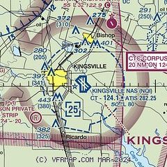
| Sectional chart |
|---|
|
 Download PDF
of official airport diagram from the FAA
| Airport distance calculator |
|---|
|
|
| Sunrise and sunset |
|---|
|
Times for 23-Apr-2024
| | Local
(UTC-5) | | Zulu
(UTC) |
|---|
| Morning civil twilight | | 06:35 | | 11:35 |
| Sunrise | | 06:59 | | 11:59 |
| Sunset | | 20:00 | | 01:00 |
| Evening civil twilight | | 20:24 | | 01:24 |
|
| Current date and time |
|---|
| Zulu (UTC) | 24-Apr-2024 00:31:08 |
|---|
| Local (UTC-5) | 23-Apr-2024 19:31:08 |
|---|
|
| METAR |
|---|
| KNQI | 232356Z 14013G19KT 10SM SCT018 SCT034 OVC055 26/22 A2995 RMK AO2 SLP140 60000 T02610217 10283 20256 56010
|
KIKG
12nm W | 240015Z AUTO 11011KT 10SM SCT030 BKN036 OVC046 25/21 A2996 RMK AO2 T02480207
|
KRBO
18nm N | 240015Z AUTO 13013G16KT 10SM SCT017 BKN029 OVC040 24/21 A2997 RMK AO2 T02430210
|
KALI
18nm NW | 232353Z AUTO 12008G17KT 10SM BKN018 OVC032 25/21 A2995 RMK AO2 SLP141 T02500206 10272 20239 55011
|
|
| TAF |
|---|
| KNQI | 2323/2423 14015G22KT 9999 VCSH SCT018 SCT030 BKN050 QNH2994INS TEMPO 2323/2402 SCT012 BKN018 OVC035 BECMG 2402/2404 15008KT 9999 BKN014 OVC030 QNH2996INS FM241500 15012KT 9999 BKN025 BKN045 QNH3003INS FM242000 13016G23KT 9999 SCT030 BKN055 QNH2995INS AUTOMATED SENSOR METWATCH 2405 TIL 2412 TX30/2420Z TN21/2412Z FN20042
|
KALI
18nm NW | 231736Z 2318/2418 15008KT P6SM OVC022 TEMPO 2321/2401 SCT025 BKN035 FM240100 13009KT P6SM SCT020 BKN025 FM240600 14005KT P6SM SCT007 BKN010 FM241500 15010KT P6SM SCT020 BKN025
|
|
| NOTAMs |
|---|
NOTAMs are issued by the DoD/FAA and will open in a separate window not controlled by AirNav.
|
|


