FAA INFORMATION EFFECTIVE 15 MAY 2025
Location
| FAA Identifier: | OMK |
| Lat/Long: | 48-27-51.8840N 119-31-04.9850W
48-27.864733N 119-31.083083W
48.4644122,-119.5180514
(estimated) |
| Elevation: | 1304.5 ft. / 397.6 m (surveyed) |
| Variation: | 16E (2015) |
| From city: | 3 miles N of OMAK, WA |
| Time zone: | UTC -7 (UTC -8 during Standard Time) |
| Zip code: | 98849 |
Airport Operations
| Airport use: | Open to the public |
| Activation date: | 12/1943 |
| Control tower: | no |
| ARTCC: | SEATTLE CENTER |
| FSS: | SEATTLE FLIGHT SERVICE STATION |
| NOTAMs facility: | OMK (NOTAM-D service available) |
| Attendance: | UNATNDD |
| Wind indicator: | lighted |
| Segmented circle: | yes |
| Lights: | ACTVT REIL RWY 17 & 35; MIRL RWY 17/35, - CTAF. PAPI RWY 17 & 35 OPRS CONSLY. |
| Beacon: | white-green (lighted land airport)
Operates sunset to sunrise. |
Airport Communications
| CTAF/UNICOM: | 122.8 |
| WX ASOS: | 118.325 (509-826-2655) |
- COMMUNICATIONS PRVDD BY SEATTLE RADIO ON FREQ 122.2 (OMAK RCO).
- APCH/DEP CTL SVC PRVDD BY SEATTLE ARTCC (ZSE) ON FREQS 126.1/291.6 (MARLIN RCAG).
Airport Services
| Fuel available: | 100LL JET-A
100LL:FUEL AVBL 24 HRS - CREDIT CARD, NO GOVT CREDIT CARDS ACPTD. |
| Parking: | tiedowns |
| Airframe service: | NONE |
| Powerplant service: | NONE |
| Bottled oxygen: | NONE |
| Bulk oxygen: | NONE |
Runway Information
Runway 17/35
| Dimensions: | 4667 x 75 ft. / 1423 x 23 m |
| Surface: | asphalt/grooved, in good condition |
| Weight bearing capacity: | | Single wheel: | 75.0 | | Double wheel: | 200.0 | | Double tandem: | 400.0 |
|
| Runway edge lights: | medium intensity |
| RUNWAY 17 | | RUNWAY 35 |
| Latitude: | 48-28.243637N | | 48-27.485830N |
| Longitude: | 119-30.991607W | | 119-31.174547W |
| Elevation: | 1304.5 ft. | | 1298.4 ft. |
| Traffic pattern: | left | | left |
| Runway heading: | 173 magnetic, 189 true | | 353 magnetic, 009 true |
| Markings: | basic, in fair condition | | basic, in fair condition |
| Visual slope indicator: | 2-light PAPI on left (3.00 degrees glide path)
UNUSBL BYD 2.5 NM, DOES NOT PRVD OBSTN CLNC BYD 2.5 NM FROM THR. | | 2-light PAPI on left (3.00 degrees glide path) |
| Runway end identifier lights: | yes | | yes |
| Touchdown point: | yes, no lights | | yes, no lights |
Airport Ownership and Management from official FAA records
| Ownership: | Publicly-owned |
| Owner: | CITY OF OMAK
2 NORTH ASH STREET, PO BOX 72
OMAK, WA 98841
Phone 509-826-1170 |
| Manager: | WAYNE BEETCHENOW
2 NORTH ASH STREET, PO BOX 72
OMAK, WA 98841
Phone 509-826-1170
CELL NMBR 509-322-4046, WKENDS ONLY. |
Additional Remarks
| - | FOR CD IF UNA TO CTC ON FSS FREQ, CTC SEATTLE ARTCC AT 253-351-3694. |
| - | COLD TEMPERATURE AIRPORT. ALTITUDE CORRECTION REQUIRED AT OR BELOW -15C. |
Instrument Procedures
NOTE: All procedures below are presented as PDF files. If you need a reader for these files, you should download the free Adobe Reader.NOT FOR NAVIGATION. Please procure official charts for flight.
FAA instrument procedures published for use from 15 May 2025 at 0901Z to 13 June 2025 at 0900z.
IAPs - Instrument Approach Procedures |
|---|
| GPS RWY 35 | |
download (303KB) |
|
|---|
| EPHRATA ONE (OBSTACLE) (RNAV) | |
download (189KB) |
| NOTE: Special Take-Off Minimums/Departure Procedures apply | |
download (534KB) |
Other nearby airports with instrument procedures:
2S8 - Wilbur Airport (53 nm SE)
KEPH - Ephrata Municipal Airport (69 nm S)
KEAT - Pangborn Memorial Airport (70 nm SW)
KMWH - Grant County International Airport (76 nm S)
KDEW - Deer Park Airport (89 nm E)
|
|

Road maps at:
MapQuest
Bing
Google
| Aerial photo |
|---|
WARNING: Photo may not be current or correct
 Photo by Domenick Venezia, 2003-09-26
Do you have a better or more recent aerial photo of Omak Airport that you would like to share? If so, please send us your photo.
|
| Sectional chart |
|---|
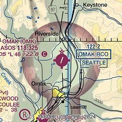
|
| Airport distance calculator |
|---|
|
|
| Sunrise and sunset |
|---|
|
Times for 17-May-2025
| | Local
(UTC-7) | | Zulu
(UTC) |
|---|
| Morning civil twilight | | 04:38 | | 11:38 |
| Sunrise | | 05:16 | | 12:16 |
| Sunset | | 20:33 | | 03:33 |
| Evening civil twilight | | 21:11 | | 04:11 |
|
| Current date and time |
|---|
| Zulu (UTC) | 17-May-2025 14:34:26 |
|---|
| Local (UTC-7) | 17-May-2025 07:34:26 |
|---|
|
| METAR |
|---|
| KOMK | 171353Z AUTO 00000KT 10SM OVC065 09/09 A2986 RMK AO2 SLP111 T00940094 $
|
|
| NOTAMs |
|---|
NOTAMs are issued by the DoD/FAA and will open in a separate window not controlled by AirNav.
|
|


