FAA INFORMATION EFFECTIVE 14 MAY 2026
Location
| FAA Identifier: | SVW |
| Lat/Long: | 61-05-49.6100N 155-34-29.3100W
61-05.826833N 155-34.488500W
61.0971139,-155.5748083
(estimated) |
| Elevation: | 1565 ft. / 477.0 m (surveyed) |
| Variation: | 12E (2025) |
| Time zone: | UTC -8 (UTC -9 during Standard Time) |
Airport Operations
| Airport use: | Private use, CLSD TO PUB; OFFL BUS ONLY. |
| Activation date: | 05/1952 |
| Control tower: | no |
| ARTCC: | ANCHORAGE CENTER |
| FSS: | KENAI FLIGHT SERVICE STATION [907-283-7211] |
| NOTAMs facility: | PASV (NOTAM-D service available) |
| Attendance: | MON-FRI 0800-1700
CLSD HOLS. |
| Wind indicator: | yes |
| Segmented circle: | no |
Airport Communications
| CTAF: | 126.2 |
| WX AWOS-3: | PHONE 907-731-9001 |
- APCH/DEP SVC PRVDD BY ANCHORAGE ARTCC ON FREQS 134.3/351.8 (SPARREVOHN RCAG).
Nearby radio navigation aids
| VOR radial/distance | | VOR name | | Freq | | Var |
|---|
| SQAr075/1.7 | | SPARREVOHN VOR/DME | | 117.20 | | 18E |
| NDB name | | Hdg/Dist | | Freq | | Var | | ID |
|---|
| CAIRN MOUNTAIN | | at field | | 281 | | 15E | | CRN | -.-. .-. -. |
Airport Services
Runway Information
Runway 17/35
| Dimensions: | 4200 x 150 ft. / 1280 x 46 m |
| Surface: | gravel, in good condition |
| Runway edge markings: | 4 FT ORANGE MKRS - THR MKD ON RWY END. |
| Operational restrictions: | 60 FT OVRN S END. |
| RUNWAY 17 | | RUNWAY 35 |
| Latitude: | 61-06.171517N | | 61-05.482203N |
| Longitude: | 155-34.488695W | | 155-34.488292W |
| Elevation: | 1565.0 ft. | | 1364.9 ft. |
| Traffic pattern: | left | | left |
| Runway heading: | 168 magnetic, 180 true | | 348 magnetic, 360 true |
| Markings: | NSTD | | NSTD |
| Visual slope indicator: | | | 2-light PAPI on right (4.00 degrees glide path) |
| Runway end identifier lights: | no | | yes |
| Touchdown point: | yes, no lights | | yes, no lights |
| Obstructions: | hill, 50 ft. from runway, 3:1 slope to clear
HILL 1413. | | hill, 3960 ft. from runway, 10:1 slope to clear |
Airport Ownership and Management from official FAA records
| Ownership: | U.S. Air Force |
| Owner: | US AIR FORCE
611 AIR SUPPORT GROUP, 10471 20TH STREET, SUITE 361
ELMENDORF AFB, AK 99506-2150
Phone 907-552-3442 |
| Manager: | NICK HILTON
611 AIR SUPPORT SQUADRON, 10471 20TH STREET, SUITE 222
ELMENDORF AFB, AK 99506-2270
Phone 907-552-4400 |
Additional Remarks
| - | MTS ALL QUADS; RWY ON SLP OF 3200 FT MT. |
| - | PPR ALL OPS; MNM 1 HR PRIOR TO DEP FOR SITE & NO EARLIER THAN DAY TRAVEL - D317-552-1244/1157/C907-552-1244/1157. |
| - | PAX MUST COORD BFR NON EMERG TRAVEL TO SITE - D317-552-4935/1089/C907-552-4935/1089. |
| - | GTR THAN 20 KT WIND/25 KT RADOME WIND MAY PRODUCE SVR TURB; RADOME WIND NOT ALWAYS AVBL. |
| - | APCH FM S; LND RWY 35 ONLY; TKOF RWY 17 ONLY; DALGT OPS ONLY. SUCCESSFUL GO AROUND IMPROBABLE. |
| - | AFT INITIAL RDO CTC ON 126.2 OR 121.5 EXP 30 MIN DLA FOR COND RPRT. |
| - | RADIO-121.5. |
| - | USAF FAC; CIV ACFT LNDG PMT RQRD BFR ARR; PMT RQRD ON BOARD; VIOLATORS FINED & RPTD TO FAA FSDOS IAW 32CFR855 & USAF OPRG INSTRNS - D317-552-5282/C907-552-5282 OR MAIL ATTN: 11 AF AMGR 10471 20TH ST SUITE 218 ELMENDORF AFB AK 99506. |
Instrument Procedures
NOTE: All procedures below are presented as PDF files. If you need a reader for these files, you should download the free Adobe Reader.NOT FOR NAVIGATION. Please procure official charts for flight.
FAA instrument procedures published for use from 14 May 2026 at 0901Z to 11 June 2026 at 0900Z.
IAPs - Instrument Approach Procedures |
|---|
| RNAV (GPS) RWY 35 | |
download (134KB) |
| NDB RWY 35 | |
download (121KB) |
| NOTE: Special Take-Off Minimums/Departure Procedures apply | |
download (399KB) |
Other nearby airports with instrument procedures:
PASL - Sleetmute Airport (58 nm NW)
PAKX - Wilder Runway Airport (65 nm SE)
PANO - Nondalton Airport (70 nm S)
PAIL - Iliamna Airport (83 nm S)
PACJ - Crooked Creek Airport (87 nm NW)
|
|

Road maps at:
MapQuest
Bing
Google
| Aerial photo |
|---|
WARNING: Photo may not be current or correct
 Photo by Security Aviation
Photo taken 06-Nov-2013
looking north-northwest.
Photo by Security Aviation
Photo taken 06-Nov-2013
looking north-northwest.
Do you have a better or more recent aerial photo of Sparrevohn LRRS Airport that you would like to share? If so, please send us your photo.
|
| Sectional chart |
|---|
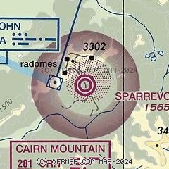
|
| Airport distance calculator |
|---|
|
|
| Sunrise and sunset |
|---|
|
Times for 07-Jun-2026
| | Local
(UTC-8) | | Zulu
(UTC) |
|---|
| Morning civil twilight | | 02:44 | | 10:44 |
| Sunrise | | 04:52 | | 12:52 |
| Sunset | | 23:50 | | 07:50 |
| Evening civil twilight | | 01:59 | | 09:59 |
|
| Current date and time |
|---|
| Zulu (UTC) | 07-Jun-2026 17:03:37 |
|---|
| Local (UTC-8) | 07-Jun-2026 09:03:37 |
|---|
|
| METAR |
|---|
| PASV | 071555Z AUTO 30003KT 10SM FEW055 BKN090 07/04 A2959 RMK AO2 SHRAB1432E1540 SLP021 T00660041;
|
|
| NOTAMs |
|---|
NOTAMs are issued by the DoD/FAA and will open in a separate window not controlled by AirNav.
|
|

