FAA INFORMATION EFFECTIVE 14 MAY 2026
Location
| FAA Identifier: | 6K8 |
| Lat/Long: | 63-19-46.2515N 142-57-13.2625W
63-19.770858N 142-57.221042W
63.3295143,-142.9536840
(estimated) |
| Elevation: | 1642.8 ft. / 500.7 m (surveyed) |
| Variation: | 17E (2025) |
| From city: | 1 mile E of TOK, AK |
| Time zone: | UTC -8 (UTC -9 during Standard Time) |
| Zip code: | 99780 |
Airport Operations
| Airport use: | Open to the public |
| Activation date: | 11/1983 |
| Control tower: | no |
| ARTCC: | ANCHORAGE CENTER |
| FSS: | NORTHWAY FLIGHT SERVICE STATION [907-778-2219] |
| Alternate FSS: | FAI FAIRBANKS FLIGHT SERVICE STATION [1-866-248-6516] |
| NOTAMs facility: | ORT (NOTAM-D service available) |
| Attendance: | MON-FRI 0800-1800 |
| Wind indicator: | lighted |
| Segmented circle: | yes |
| Lights: | ACTVT MIRL RWY 08/26 - CTAF. |
| Beacon: | white-green (lighted land airport)
Operates sunset to sunrise. |
Airport Communications
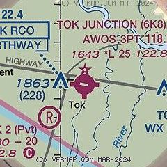
| CTAF/UNICOM: | 122.8 |
| WX AWOS-3P: | 118.1 (907-269-2706) |
- APCH/DEP SVC PRVDD BY ANCHORAGE ARTCC ON FREQS 126.55/323.0 (NORTHWAY RCAG).
- COMMUNICATIONS PRVDD BY NORTHWAY FSS ON FREQ 122.4 (TOK RCO).
Nearby radio navigation aids
| VOR radial/distance | | VOR name | | Freq | | Var |
|---|
| ORTr292/36.4 | | NORTHWAY VORTAC | | 116.30 | | 17E |
Airport Services
| Fuel available: | 100LL JET-A
A:FOR SVC - 907-883-5191.
100LL:SELF SVC H24 WITH CREDIT CARD. |
| Parking: | tiedowns |
Runway Information
Runway 8/26
| Dimensions: | 2509 x 50 ft. / 765 x 15 m |
| Surface: | asphalt, in good condition |
| Runway edge lights: | medium intensity |
| Runway edge markings: | NR BFR THR. MKD WITH CONES & LGTS. |
| Operational restrictions: | 198 FT TWR 4603 FT NW RWY 08 THR. |
| RUNWAY 8 | | RUNWAY 26 |
| Latitude: | 63-19.803567N | | 63-19.738150N |
| Longitude: | 142-57.673183W | | 142-56.768900W |
| Elevation: | 1642.5 ft. | | 1642.6 ft. |
| Traffic pattern: | left | | left |
| Runway heading: | 082 magnetic, 099 true | | 262 magnetic, 279 true |
| Markings: | NSTD, in fair condition | | NSTD, in fair condition |
| Touchdown point: | yes, no lights | | yes, no lights |
| Obstructions: | 57 ft. trees, 300 ft. from runway, 265 ft. both sides of centerline, 1:1 slope to clear | | 35 ft. trees, 510 ft. from runway, 320 ft. both sides of centerline, 8:1 slope to clear |
Airport Ownership and Management from official FAA records
| Ownership: | Publicly-owned |
| Owner: | ALASKA DOT&PF NORTHERN REGION
2301 PEGER RD
FAIRBANKS, AK 99709
Phone 907-451-2200 |
| Manager: | SAM JENNINGS
P O BOX 356
TOK, AK 99787
Phone 907-883-5128 |
Additional Remarks
| - | RCMD VISUAL INSP BFR LNDG; RWY PLOWED IN WINTER. |
| - | SUAIS - 125.3 126.3 (1-800-758-8723). |
| - | WX CAMERA AVBL ON INTERNET AT HTTPS://WEATHERCAMS.FAA.GOV |
Instrument Procedures
NOTE: All procedures below are presented as PDF files. If you need a reader for these files, you should download the free Adobe Reader.NOT FOR NAVIGATION. Please procure official charts for flight.
FAA instrument procedures published for use from 14 May 2026 at 0901Z to 11 June 2026 at 0900Z.
IAPs - Instrument Approach Procedures |
|---|
| RNAV (GPS) RWY 08 | |
download (376KB) |
| RNAV (GPS)-A | |
download (255KB) |
| NOTE: Special Alternate Minimums apply | |
download (173KB) |
Departure Procedures |
|---|
| GULKANA TWO (RNAV) | |
download (150KB) |
|
|---|
| EGAXE ONE (OBSTACLE) (RNAV) | |
download (346KB) |
| EGAXE ONE (OBSTACLE) (RNAV) | |
download (346KB) |
| NOTE: Special Take-Off Minimums/Departure Procedures apply | |
download (395KB) |
Other nearby airports with instrument procedures:
PAOR - Northway Airport (36 nm SE)
PABI - Allen Army Airfield (84 nm NW)
PAGK - Gulkana Airport (98 nm SW)
PAEG - Eagle Airport (99 nm NE)
|
|

Road maps at:
MapQuest
Bing
Google
| Aerial photo |
|---|
WARNING: Photo may not be current or correct
 Photo by Bryan Painter
Photo taken 30-Aug-2008
Photo by Bryan Painter
Photo taken 30-Aug-2008
Do you have a better or more recent aerial photo of Tok Junction Airport that you would like to share? If so, please send us your photo.
|
| Sectional chart |
|---|
|
| Airport distance calculator |
|---|
|
|
| Sunrise and sunset |
|---|
|
Times for 06-Jun-2026
| | Local
(UTC-8) | | Zulu
(UTC) |
|---|
| Morning civil twilight | | + | | + |
| Sunrise | | 03:31 | | 11:31 |
| Sunset | | 23:30 | | 07:30 |
| Evening civil twilight | | + | | + |
|
| Current date and time |
|---|
| Zulu (UTC) | 06-Jun-2026 13:25:59 |
|---|
| Local (UTC-8) | 06-Jun-2026 05:25:59 |
|---|
|
| METAR |
|---|
| PFTO | 061256Z AUTO 00000KT 10SM BKN075 BKN100 07/04 A2957 RMK AO2 SLP525 T00670044 $
|
|
| TAF |
|---|
PAOR
35nm SE | 061137Z 0612/0712 VRB03KT P6SM VCSH BKN100 FM061800 27007KT P6SM VCSH BKN080
|
|
| NOTAMs |
|---|
NOTAMs are issued by the DoD/FAA and will open in a separate window not controlled by AirNav.
|
|

