FAA INFORMATION EFFECTIVE 19 MARCH 2026
Location
| FAA Identifier: | PGA |
| Lat/Long: | 36-55-33.8500N 111-26-54.0620W
36-55.564167N 111-26.901033W
36.9260694,-111.4483506
(estimated) |
| Elevation: | 4316.6 ft. / 1315.7 m (surveyed) |
| Variation: | 14E (1980) |
| From city: | 1 mile E of PAGE, AZ |
| Time zone: | UTC -7 (year round; does not observe DST) |
| Zip code: | 86040 |
Airport Operations
| Airport use: | Open to the public |
| Activation date: | 09/1957 |
| Control tower: | no |
| ARTCC: | DENVER CENTER |
| FSS: | PRESCOTT FLIGHT SERVICE STATION |
| NOTAMs facility: | PGA (NOTAM-D service available) |
| Attendance: | DAYLIGHT HOURS |
| Wind indicator: | lighted |
| Segmented circle: | yes |
| Lights: | ACTVT REIL RWY 15 & 33; MIRL 15/33 - CTAF. VASI RWY 15 & 33 ON CONSLY. |
| Beacon: | white-green (lighted land airport)
Operates sunset to sunrise. |
| Landing fee: | no, OVNGT PRKG FEE. |
| Fire and rescue: | ARFF index A |
| Airline operations: | RWY 15/33 CLSD TO ACR OPS MORE THAN 30 PAX SEATS EXC 24 HR PPR - AMGR. RWY 7/25 CLSD TO SKED ACR OPS MORE THAN 9 PAX SEATS OR UNSKED ACR OPS LEAST 31 PAX SEATS. |
Airport Communications
| CTAF/UNICOM: | 122.8 |
| WX ASOS: | 120.625 (928-900-3166) |
- UNICOM ADZY AVBL 122.8 SR - SS.
- APCH/DEP CTL SVC PRVDD BY DENVER ARTCC (ZDV) ON FREQ 127.55/256.875 (TUBA CITY RCAG).
Nearby radio navigation aids
| VOR radial/distance | | VOR name | | Freq | | Var |
|---|
| PGA at field | | PAGE VOR/DME | | 116.45 | | 13E |
Airport Services
| Fuel available: | 100LL JET-A
100LL:AFT HR - 928-645-5356. |
| Parking: | tiedowns |
| Airframe service: | MAJOR |
| Powerplant service: | MAJOR |
| Bottled oxygen: | HIGH/LOW |
| Bulk oxygen: | HIGH |
Runway Information
Runway 15/33
| Dimensions: | 5950 x 150 ft. / 1814 x 46 m |
| Surface: | asphalt, in good condition |
| Weight bearing capacity: | | Single wheel: | 65.0 | | Double wheel: | 93.0 | | Double tandem: | 157.0 |
|
| Runway edge lights: | medium intensity |
| RUNWAY 15 | | RUNWAY 33 |
| Latitude: | 36-55.969157N | | 36-55.003483N |
| Longitude: | 111-26.973775W | | 111-26.764213W |
| Elevation: | 4245.3 ft. | | 4316.6 ft. |
| Traffic pattern: | left | | right |
| Runway heading: | 156 magnetic, 170 true | | 336 magnetic, 350 true |
| Declared distances: | TORA:5950 TODA:5950 ASDA:5950 LDA:5950 | | TORA:5950 TODA:5950 ASDA:5950 LDA:5950 |
| Markings: | nonprecision, in good condition | | nonprecision, in good condition |
| Visual slope indicator: | 4-box VASI on left (3.00 degrees glide path) | | 4-box VASI on left (3.00 degrees glide path) |
| Runway end identifier lights: | yes | | yes |
| Touchdown point: | yes, no lights | | yes, no lights |
Runway 7/25
| Dimensions: | 2201 x 75 ft. / 671 x 23 m |
| Surface: | asphalt, in good condition |
| Weight bearing capacity: | | PCN 2 /F/D/Y/T | | Double wheel: | 12.5 |
|
| Operational restrictions: | CLSD INDEFLY. |
| RUNWAY 7 | | RUNWAY 25 |
| Latitude: | 36-55.749602N | | 36-55.799615N |
| Longitude: | 111-27.211310W | | 111-26.764028W |
| Elevation: | 4243.1 ft. | | 4250.7 ft. |
| Traffic pattern: | left | | right |
| Runway heading: | 068 magnetic, 082 true | | 248 magnetic, 262 true |
| Displaced threshold: | 588 ft. | | no |
| Declared distances: | TORA:2201 TODA:2201 ASDA:2201 LDA:1613 | | TORA:2201 TODA:2201 ASDA:2201 LDA:2201 |
| Markings: | basic, in fair condition | | numbers only, in fair condition |
| Runway end identifier lights: | no | | no |
| Touchdown point: | yes, no lights | | yes, no lights |
Airport Ownership and Management from official FAA records
| Ownership: | Publicly-owned |
| Owner: | CITY OF PAGE
BOX 1180
PAGE, AZ 86040
Phone 928-645-8861 |
| Manager: | LORE DAVIS-MCCLUSKEY
PO BOX 1180, 697 VISTA AVENUE
PAGE, AZ 86040
Phone 928-645-4240 |
Additional Remarks
| A39-15/33 | PCR VALUE: 249/F/C/X/T |
| - | FOR CD CTC DENVER ARTCC ON FREQ. IF UNA, CTC FSS ON FREQ VIA RCO. IF UNA, CTC DENVER ARTCC AT 303-651-4257. |
Instrument Procedures
NOTE: All procedures below are presented as PDF files. If you need a reader for these files, you should download the free Adobe Reader.NOT FOR NAVIGATION. Please procure official charts for flight.
FAA instrument procedures published for use from 19 March 2026 at 0901Z to 16 April 2026 at 0900Z.
IAPs - Instrument Approach Procedures |
|---|
| RNAV (GPS) RWY 15 | |
download (254KB) |
| RNAV (GPS) RWY 33 | |
download (248KB) |
| VOR-B | |
download (179KB) |
| NOTE: Special Take-Off Minimums/Departure Procedures apply | |
download (160KB) |
Other nearby airports with instrument procedures:
1L7 - Escalante Municipal Airport (50 nm N)
KKNB - Kanab Municipal Airport (52 nm W)
KBCE - Bryce Canyon Airport (57 nm NW)
KGCN - Grand Canyon National Park Airport (67 nm SW)
U55 - Panguitch Municipal Airport (71 nm NW)
|
|

Road maps at:
MapQuest
Bing
Google
| Aerial photo |
|---|
WARNING: Photo may not be current or correct
 Photo by Andreas Lauschke
Photo taken 28-Dec-2024
looking east.
Photo by Andreas Lauschke
Photo taken 28-Dec-2024
looking east.
Do you have a better or more recent aerial photo of Page Municipal Airport that you would like to share? If so, please send us your photo.
|
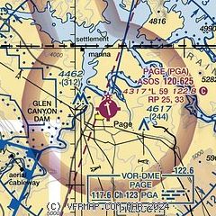
| Sectional chart |
|---|
|
CAUTION: Diagram may not be current

| Airport distance calculator |
|---|
|
|
| Sunrise and sunset |
|---|
|
Times for 13-Apr-2026
| | Local
(UTC-7) | | Zulu
(UTC) |
|---|
| Morning civil twilight | | 05:29 | | 12:29 |
| Sunrise | | 05:55 | | 12:55 |
| Sunset | | 18:57 | | 01:57 |
| Evening civil twilight | | 19:24 | | 02:24 |
|
| Current date and time |
|---|
| Zulu (UTC) | 13-Apr-2026 11:22:56 |
|---|
| Local (UTC-7) | 13-Apr-2026 04:22:56 |
|---|
|
| METAR |
|---|
| KPGA | 131053Z AUTO 19004KT CLR 11/M06 A2995 RMK AO2 SLP098 T01111061 $
|
|
| TAF |
|---|
| KPGA | 130520Z 1306/1406 23010G20KT P6SM SKC FM130800 20006KT P6SM FEW140 FM131600 22011G22KT P6SM FEW100 FM140300 24010G20KT P6SM VCSH SCT080 PROB30 1403/1406 4SM -SHRA BKN040
|
|
| NOTAMs |
|---|
NOTAMs are issued by the DoD/FAA and will open in a separate window not controlled by AirNav.
|
|


