FAA INFORMATION EFFECTIVE 19 MARCH 2026
Location
| FAA Identifier: | MKK |
| Lat/Long: | 21-09-10.3890N 157-05-46.5220W
21-09.173150N 157-05.775367W
21.1528858,-157.0962561
(estimated) |
| Elevation: | 453.9 ft. / 138.3 m (surveyed) |
| Variation: | 11E (1980) |
| From city: | 6 miles NW of KAUNAKAKAI, HI |
| Time zone: | UTC -10 (year round; does not observe DST) |
| Zip code: | 96729 |
Airport Operations
| Airport use: | Open to the public |
| Activation date: | 07/1946 |
| Control tower: | yes |
| ARTCC: | HONOLULU CONTROL FACILITY CENTER |
| FSS: | HONOLULU FLIGHT SERVICE STATION |
| NOTAMs facility: | MKK (NOTAM-D service available) |
| Attendance: | 0500-2015 |
| Pattern altitude: | TPA SMALL ACFT 1250' MSL. LARGE ACFT 1950' MSL. |
| Wind indicator: | lighted |
| Segmented circle: | yes |
| Lights: | WHEN ATCT CLSD ACTVT MIRL RY 05/23 AND RY 17/35, REIL RY 05 - CTAF. |
| Beacon: | white-green (lighted land airport)
Operates sunset to sunrise. |
| Fire and rescue: | ARFF index A |
| Airline operations: | ARPT CLOSED TO AIR CARRIER OPS WITH 10 OR MORE PASSENGER SEATS 1930-0600 EXCEPT PPR, CALL 808-567-9660/9663. |
Airport Communications
| CTAF: | 125.7 |
| ATIS: | 128.2 |
| WX ASOS: | PHONE 808-865-6936 |
| MOLOKAI GROUND: | 121.9 [0600-1830] |
| MOLOKAI TOWER: | 125.7 306.2 [0600-1830] |
| EMERG: | 121.5 243.0 |
- APCH/DEP SVC PRVDD BY HONOLULU CONTROL FACILITY (ZHN) ON FREQS 124.1/317.5 (MOUNT HALEAKALA RCAG).
Nearby radio navigation aids
| VOR radial/distance | | VOR name | | Freq | | Var |
|---|
| MKKr066/4.1 | | MOLOKAI VORTAC | | 116.10 | | 11E |
| LNYr332/24.4 | | LANAI VORTAC | | 117.70 | | 11E |
| CKHr090/34.6 | | KOKO HEAD VORTAC | | 113.90 | | 11E |
Airport Services
Runway Information
Runway 5/23
| Dimensions: | 4494 x 100 ft. / 1370 x 30 m |
| Surface: | asphalt/grooved, in good condition |
| Weight bearing capacity: | | Single wheel: | 30.0 | | Double wheel: | 60.0 |
|
| Runway edge lights: | medium intensity |
| RUNWAY 5 | | RUNWAY 23 |
| Latitude: | 21-08.978067N | | 21-09.344433N |
| Longitude: | 157-06.064417W | | 157-05.376317W |
| Elevation: | 437.1 ft. | | 453.9 ft. |
| Traffic pattern: | left | | left |
| Runway heading: | 049 magnetic, 060 true | | 229 magnetic, 240 true |
| Displaced threshold: | no | | 593 ft. |
| Declared distances: | TORA:4494 TODA:4494 ASDA:4494 LDA:4494 | | TORA:4494 TODA:4494 ASDA:4494 LDA:3901 |
| Markings: | nonprecision, in good condition | | nonprecision, in good condition |
| Visual slope indicator: | 4-light PAPI on left (4.00 degrees glide path)
PAPI NOT AUTHORIZED 1.8 NM BYD LDG THLD DUE TO RAPIDLY RISING TERRAIN. | | |
| Runway end identifier lights: | yes | | no |
| Touchdown point: | yes, no lights | | yes, no lights |
| Obstructions: | none | | 23 ft. brush, 400 ft. from runway, 17:1 slope to clear
APCH RATIO FROM DSPLCD THLD 23:1. |
Runway 17/35
| Dimensions: | 3118 x 100 ft. / 950 x 30 m |
| Surface: | asphalt, in fair condition |
| Weight bearing capacity: | |
| Runway edge lights: | medium intensity |
| RUNWAY 17 | | RUNWAY 35 |
| Latitude: | 21-09.447800N | | 21-08.932817N |
| Longitude: | 157-05.854467W | | 157-05.854767W |
| Elevation: | 448.4 ft. | | 430.3 ft. |
| Traffic pattern: | left | | left |
| Runway heading: | 169 magnetic, 180 true | | 349 magnetic, 000 true |
| Displaced threshold: | 426 ft. | | no |
| Declared distances: | TORA:3118 TODA:3118 ASDA:3118 LDA:2692 | | TORA:3118 TODA:3118 ASDA:3118 LDA:3118 |
| Markings: | basic, in good condition | | basic, in good condition |
| Runway end identifier lights: | no | | no |
| Touchdown point: | yes, no lights | | yes, no lights |
| Obstructions: | 12 ft. fence, 80 ft. from runway
APCH RATIO 23:1 FROM DSPLCD THLD. | | 4 ft. fence, 248 ft. from runway, 12:1 slope to clear |
Airport Ownership and Management from official FAA records
| Ownership: | Publicly-owned |
| Owner: | HAWAII STATE AIRPORTS DIV
HONOLULU INTL ARPT
HONOLULU, HI 96819
Phone 808-838-8600 |
| Manager: | MARVIN MONIZ
KAHULUI ARPT
KAHULUI, HI 96732
Phone 808-281-9898 |
Additional Remarks
| A39-05/23 | PCR VALUE: 104/F/A/X/T |
| A39-17/35 | PCR VALUE: 124/F/B/X/T |
| E94 | LAWRS AVBL FROM TWR PERSONNEL 0600-1900 LCL. |
| - | 24 HRS PPR FOR DIVISION 1.1,1.2,1.3 EXPLOSIVES AND 4 HRS PPR FOR OTHER HAZARDOUS MATERIAL IN/OUT OF ARPT CTC 808-567-6140/6008. |
| - | MTN APPROXIMATELY 1280' MSL LCTD 2.8 NM FROM RWY 05 THR ON CNTRLN EXTDD. |
| - | BE ALERT TO EGRETS AND PIGEONS ON & INVOF ARPT. |
| - | LARGE ACFT WITH WINGSPAN GREATER THAN 78 FT MAY NOT USE TWY A OR RY 05/23 FOR SIMULTANEOUS OPNS. |
| - | STANDING WATER/PONDING ON RY 17/35 NEAR TWY ECHO DURING INCLEMENT WEATHER. |
| - | FOR CD WHEN ATCT IS CLSD CTC HONOLULU CONTROL FACILITY AT 808-840-6262. |
| - | (CONTACT TITLE) ARPT OPNS/MAINT/AOM/MR. ANTONE KALILIKANE (808) 567-9660. |
Instrument Procedures
NOTE: All procedures below are presented as PDF files. If you need a reader for these files, you should download the free Adobe Reader.NOT FOR NAVIGATION. Please procure official charts for flight.
FAA instrument procedures published for use from 19 March 2026 at 0901Z to 16 April 2026 at 0900Z.
IAPs - Instrument Approach Procedures |
|---|
| RNAV (GPS)-B | |
download (234KB) |
| VOR OR TACAN-A | |
download (213KB) |
| NOTE: Special Alternate Minimums apply | |
download (134KB) |
Departure Procedures |
|---|
| BLUSH TWO | |
download (123KB) |
| HAPAI THREE | |
download (176KB) |
| KALAE ONE (RNAV) | |
download (185KB) |
| MAULA ONE (RNAV) | |
download (163KB) |
|
|---|
| KAUNAKAKAI ONE (OBSTACLE) | |
2 pages:
[1] [2] (522KB) |
| NOTE: Special Take-Off Minimums/Departure Procedures apply | |
download |
Other nearby airports with instrument procedures:
PHLU - Kalaupapa Airport (8 nm NE)
PHNY - Lanai Airport (23 nm S)
PHOG - Kahului Airport (40 nm E)
PHNG - Kaneohe Bay Marine Corps Air Station (Marion E Carl Field) (42 nm NW)
PHNL - Daniel K Inouye International Airport (47 nm W)
|
|

Road maps at:
MapQuest
Bing
Google
| Aerial photo |
|---|
WARNING: Photo may not be current or correct
 Photo by Terry Cole
Photo taken 02-Feb-2013
looking southwest.
Photo by Terry Cole
Photo taken 02-Feb-2013
looking southwest.
Do you have a better or more recent aerial photo of Molokai Airport that you would like to share? If so, please send us your photo.
|
| Sectional chart |
|---|
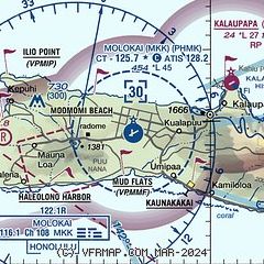
|
 Download PDF
of official airport diagram from the FAA
| Airport distance calculator |
|---|
|
|
| Sunrise and sunset |
|---|
|
Times for 14-Apr-2026
| | Local
(UTC-10) | | Zulu
(UTC) |
|---|
| Morning civil twilight | | 05:48 | | 15:48 |
| Sunrise | | 06:11 | | 16:11 |
| Sunset | | 18:46 | | 04:46 |
| Evening civil twilight | | 19:09 | | 05:09 |
|
| Current date and time |
|---|
| Zulu (UTC) | 14-Apr-2026 21:03:21 |
|---|
| Local (UTC-10) | 14-Apr-2026 11:03:21 |
|---|
|
| METAR |
|---|
| PHMK | 142054Z 35009KT 10SM FEW016 26/21 A3008 RMK AO2 SLP187 T02610211 50005
|
|
| TAF |
|---|
| PHMK | 141734Z 1418/1518 VRB06KT P6SM FEW025 FM142000 35010KT P6SM FEW025 SCT045 FM150600 VRB05KT P6SM VCSH SCT020 BKN040
|
|
| NOTAMs |
|---|
NOTAMs are issued by the DoD/FAA and will open in a separate window not controlled by AirNav.
|
|


