FAA INFORMATION EFFECTIVE 25 DECEMBER 2025
Location
| FAA Identifier: | PVU |
| Lat/Long: | 40-13-09.0000N 111-43-24.1000W
40-13.150000N 111-43.401667W
40.2191667,-111.7233611
(estimated) |
| Elevation: | 4496.9 ft. / 1370.7 m (surveyed) |
| Variation: | 12E (2010) |
| From city: | 2 miles SW of PROVO, UT |
| Time zone: | UTC -7 (UTC -6 during Daylight Saving Time) |
| Zip code: | 84601 |
Airport Operations
| Airport use: | Open to the public |
| Activation date: | 09/1942 |
| Control tower: | yes |
| ARTCC: | SALT LAKE CITY CENTER |
| FSS: | CEDAR CITY FLIGHT SERVICE STATION |
| NOTAMs facility: | PVU (NOTAM-D service available) |
| Attendance: | JUN-OCT 0600-2200, NOV-MAY 0600-2100
FOR ARPT SVCS CTC 128.85. |
| Segmented circle: | yes |
| Lights: | 24 HRS. |
| Beacon: | white-green (lighted land airport)
Operates sunset to sunrise. |
| Fire and rescue: | ARFF index B |
| Airline operations: | 24 HR PPR FOR UNSKED AIR CARRIER OPNS CALL AMGR 801-852-6715. |
Airport Communications
| CTAF: | 125.3 |
| ATIS: | 135.175 |
| WX AWOS-3PT: | 135.175 (801-373-9782) |
| PROVO GROUND: | 119.4 [0700-2100] |
| PROVO TOWER: | 125.3 [0700-2100] |
| SALT LAKE CITY APPROACH: | 118.85 |
| SALT LAKE CITY DEPARTURE: | 118.85 |
| WX AWOS-3PT at SPK (5 nm SE): | 119.275 (801-804-5801) |
- PRIM RADAR NOT AVBL. RADAR TFC ADVISORIES AND SVCS AVBL FOR TRANSPONDER EQUIPPED ACFT ONLY.
Nearby radio navigation aids
| VOR radial/distance | | VOR name | | Freq | | Var |
|---|
| PVU at field | | PROVO VOR/DME | | 108.40 | | 15E |
| FFUr093/10.5 | | FAIRFIELD VORTAC | | 116.60 | | 16E |
| TCHr147/39.7 | | WASATCH VORTAC | | 116.80 | | 16E |
Airport Services
| Fuel available: | 100 JET-A |
| Parking: | hangars and tiedowns |
| Airframe service: | MAJOR |
| Powerplant service: | MAJOR |
| Bottled oxygen: | LOW |
| Bulk oxygen: | LOW |
Runway Information
Runway 13/31
| Dimensions: | 8603 x 150 ft. / 2622 x 46 m |
| Surface: | asphalt/grooved, in good condition |
| Weight bearing capacity: | | Single wheel: | 65.0 | | Double wheel: | 85.0 | | Double tandem: | 140.0 |
|
| Runway edge lights: | high intensity |
| RUNWAY 13 | | RUNWAY 31 |
| Latitude: | 40-13.812755N | | 40-12.641175N |
| Longitude: | 111-43.946667W | | 111-42.907843W |
| Elevation: | 4496.9 ft. | | 4492.7 ft. |
| Traffic pattern: | right | | left |
| Runway heading: | 134 magnetic, 146 true | | 314 magnetic, 326 true |
| Declared distances: | TORA:8599 TODA:8599 ASDA:8599 LDA:8599 | | TORA:8599 TODA:8599 ASDA:8599 LDA:8599 |
| Markings: | precision, in good condition | | nonprecision, in good condition |
| Visual slope indicator: | 4-light PAPI on left (3.00 degrees glide path) | | 2-light PAPI on left (3.00 degrees glide path) |
| Runway end identifier lights: | yes | | |
| Touchdown point: | yes, no lights | | yes, no lights |
| Instrument approach: | ILS/DME | | |
Runway 18/36
| Dimensions: | 6628 x 150 ft. / 2020 x 46 m |
| Surface: | asphalt, in good condition |
| Weight bearing capacity: | | Single wheel: | 50.0 | | Double wheel: | 70.0 | | Double tandem: | 110.0 |
|
| Runway edge lights: | medium intensity |
| RUNWAY 18 | | RUNWAY 36 |
| Latitude: | 40-13.585933N | | 40-12.517425N |
| Longitude: | 111-43.223120W | | 111-43.513488W |
| Elevation: | 4493.7 ft. | | 4492.6 ft. |
| Traffic pattern: | right | | left |
| Runway heading: | 180 magnetic, 192 true | | 000 magnetic, 012 true |
| Declared distances: | TORA:6614 TODA:6614 ASDA:6614 LDA:6614 | | TORA:6614 TODA:6614 ASDA:6614 LDA:6614 |
| Markings: | basic, in good condition | | basic, in good condition |
| Visual slope indicator: | 2-light PAPI on left (3.00 degrees glide path) | | 2-light PAPI on left (3.00 degrees glide path) |
| Touchdown point: | yes, no lights | | yes, no lights |
Airport Ownership and Management from official FAA records
| Ownership: | Publicly-owned |
| Owner: | CITY OF PROVO
1377 S. 350 E.
PROVO, UT 84606
Phone 801-852-6715 |
| Manager: | BRIAN TORGERSEN
P. O. BOX 1849
PROVO, UT 84603
Phone 801-852-6720 |
Additional Remarks
| A39-13/31 | PCR VALUE: 534/F/D/X/T |
| A55-31 | +15' TREES 70' LEFT OF RWY CNTRLN EXTNDD. |
| - | BE ALERT; HELICOPTERS ARRIVING & DEPARTING FM RYS & TAXIWAYS. |
| - | EXTNSV FLT TRNG INVOF ARPT. |
| - | USE CAUTION FOR EXTENSIVE PARAGLIDING OPS INVOF POINT OF THE MOUNTAIN. |
| - | FOR CD WHEN ATCT IS CLSD CTC SLC APCH AT 801-325-9670. |
Instrument Procedures
NOTE: All procedures below are presented as PDF files. If you need a reader for these files, you should download the free Adobe Reader.NOT FOR NAVIGATION. Please procure official charts for flight.
FAA instrument procedures published for use from 25 December 2025 at 0901z to 22 January 2026 at 0900z.
STARs - Standard Terminal Arrivals |
|---|
| TAYTR TWO (RNAV) | |
2 pages:
[1] [2] (254KB) |
IAPs - Instrument Approach Procedures |
|---|
| ILS OR LOC RWY 13 **CHANGED** | |
download (745KB) |
| RNAV (GPS) RWY 13 **CHANGED** | |
download (722KB) |
| NOTE: Special Alternate Minimums apply | |
download (142KB) |
Departure Procedures |
|---|
| DITTI ONE (RNAV) | |
download (170KB) |
| DITTI ONE (RNAV) | |
download (170KB) |
|
|---|
| PROVO FOUR (OBSTACLE) | |
download (343KB) |
| NOTE: Special Take-Off Minimums/Departure Procedures apply | |
download (113KB) |
Other nearby airports with instrument procedures:
KSPK - Spanish Fork Municipal Airport/Woodhouse Field (5 nm SE)
KHCR - Heber Valley Airport (21 nm NE)
KSVR - South Valley Regional Airport (27 nm NW)
U14 - Nephi Municipal Airport (30 nm S)
KSLC - Salt Lake City International Airport (36 nm N)
|
|

Road maps at:
MapQuest
Bing
Google
| Aerial photo |
|---|
WARNING: Photo may not be current or correct
 Photo by R. Taylor Abegg
Photo taken 12-Oct-2020
looking north.
Photo by R. Taylor Abegg
Photo taken 12-Oct-2020
looking north.
Do you have a better or more recent aerial photo of Provo Municipal Airport that you would like to share? If so, please send us your photo.
|
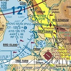
| Sectional chart |
|---|
|
CAUTION: Diagram may not be current
 Download PDF
of official airport diagram from the FAA
| Airport distance calculator |
|---|
|
|
| Sunrise and sunset |
|---|
|
Times for 25-Dec-2025
| | Local
(UTC-7) | | Zulu
(UTC) |
|---|
| Morning civil twilight | | 07:18 | | 14:18 |
| Sunrise | | 07:49 | | 14:49 |
| Sunset | | 17:05 | | 00:05 |
| Evening civil twilight | | 17:36 | | 00:36 |
|
| Current date and time |
|---|
| Zulu (UTC) | 25-Dec-2025 21:56:58 |
|---|
| Local (UTC-7) | 25-Dec-2025 14:56:58 |
|---|
|
| METAR |
|---|
| KPVU | 252056Z 23016KT 10SM CLR 12/01 A3001 RMK AO2 SLP137 T01170006 55011
|
KSPK
5nm SE | 252135Z AUTO 23018G28KT CLR 15/M01 A3000 RMK AO2 PWINO
|
|
| TAF |
|---|
| KPVU | 251906Z 2519/2618 23016G24KT P6SM SCT060 BKN100 FM260000 22011KT P6SM VCSH SCT060 BKN100
|
|
| NOTAMs |
|---|
NOTAMs are issued by the DoD/FAA and will open in a separate window not controlled by AirNav.
|
|


