FAA INFORMATION EFFECTIVE 27 NOVEMBER 2025
Location
| FAA Identifier: | RIL |
| Lat/Long: | 39-31-35.7840N 107-43-40.7530W
39-31.596400N 107-43.679217W
39.5266067,-107.7279869
(estimated) |
| Elevation: | 5536.8 ft. / 1687.6 m (surveyed) |
| Variation: | 10E (2010) |
| From city: | 3 miles E of RIFLE, CO |
| Time zone: | UTC -7 (UTC -6 during Daylight Saving Time) |
| Zip code: | 81650 |
Airport Operations
| Airport use: | Open to the public |
| Activation date: | 07/1940 |
| Control tower: | no |
| ARTCC: | DENVER CENTER |
| FSS: | DENVER FLIGHT SERVICE STATION |
| NOTAMs facility: | RIL (NOTAM-D service available) |
| Attendance: | CONTINUOUS |
| Wind indicator: | lighted |
| Segmented circle: | yes |
| Lights: | ACTVT ODALS RWY 26; REIL RWY 08; HIRL RWY 08/26 - CTAF. PAPI RWY 08 & 26 ON CONSLY. |
| Beacon: | white-green (lighted land airport)
Operates sunset to sunrise. |
| International operations: | FOR ACFT GWT 10000 LBS OR MORE. |
Airport Communications
| CTAF/UNICOM: | 122.8 |
| WX ASOS: | 135.275 (970-625-2206) |
- APCH/DEP CTL SVC PRVDD BY DENVER ARTCC (ZDV) ON FREQS 134.95/327.075 (RIFLE RCAG).
Nearby radio navigation aids
| VOR radial/distance | | VOR name | | Freq | | Var |
|---|
| RIL at field | | RIFLE VOR/DME | | 113.35 | | 10E |
| EKRr155/33.7 | | MEEKER VOR/DME | | 115.20 | | 09E |
| SXWr248/34.6 | | SNOW VOR/DME | | 109.20 | | 12E |
| DBLr266/38.9 | | RED TABLE VOR/DME | | 113.00 | | 12E |
Airport Services
| Fuel available: | 100LL JET-A
100LL:ARPT OPS-24 HRS / 970-230-1685. |
| Parking: | hangars and tiedowns |
| Airframe service: | MAJOR |
| Powerplant service: | MAJOR |
| Bottled oxygen: | LOW |
| Bulk oxygen: | HIGH |
Runway Information
Runway 8/26
| Dimensions: | 7000 x 100 ft. / 2134 x 30 m |
| Surface: | asphalt/grooved, in good condition |
| Weight bearing capacity: | | PCN 43 /F/B/X/U | | Single wheel: | 90.0 | | Double wheel: | 200.0 | | Double tandem: | 250.0 |
|
| Runway edge lights: | high intensity |
| RUNWAY 8 | | RUNWAY 26 |
| Latitude: | 39-31.580792N | | 39-31.611938N |
| Longitude: | 107-44.423213W | | 107-42.935230W |
| Elevation: | 5470.2 ft. | | 5536.8 ft. |
| Traffic pattern: | left | | right |
| Runway heading: | 078 magnetic, 088 true | | 258 magnetic, 268 true |
| Markings: | nonprecision, in good condition | | precision, in good condition |
| Visual slope indicator: | 4-light PAPI on left (3.00 degrees glide path) | | 4-light PAPI on left (3.50 degrees glide path) |
| Approach lights: | | | ODALS: omnidirectional approach lighting system |
| Runway end identifier lights: | yes | | no |
| Touchdown point: | yes, no lights | | yes, no lights |
| Instrument approach: | | | ILS/DME |
| Obstructions: | 6 ft. tower, 331 ft. from runway, 307 ft. left of centerline, 21:1 slope to clear | | none |
Airport Ownership and Management from official FAA records
| Ownership: | Publicly-owned |
| Owner: | GARFIELD COUNTY
0375 COUNTY RD 352 BLDG 2060
RIFLE, CO 81650
Phone 970-625-1091 |
| Manager: | SAM CARVER
0375 COUNTY RD 352 BLDG 2060
RIFLE, CO 81650
Phone 970-625-1091 |
Additional Remarks
| - | IFR ATC CLNC FM RIL IS NOT AUTH TO ENTER RWY OR TKOF & LNDG. |
| - | SATURATED PAT POLICY: TGLS PROHIBITED WHEN 5 OR MORE ACFT IN TFC PATTERN. |
| - | FLW FAA PROCS FOR NON-TOWERED ARPTS. |
| - | CTN: SN REMOVAL EQUIP OPS FM 1 OCT TO 15 MAY. |
| - | AFT WINTER SN STORMS ARPT OPNS BFR ALL TWYS ARE CLEARED. |
| - | OVNGT PRKG FEE. |
| - | COLD TEMPERATURE AIRPORT. ALTITUDE CORRECTION REQUIRED AT OR BELOW -13C. |
| - | FOR CD, IFUN TO CTC ON DENVER ARTCC APP/DEP CTL FREQ, CTC DENVER ARTCC AT 303-651-4257. |
| - | GLD OPS INVOF ARPT. |
| - | PROPER DUAL RDO USE (ATC/CTAF) IS ESNTL FOR SAFE AND EFFICIENT TFC FLOW. |
| - | USE CTAF PRIOR TO ENTERING RWY OR PAT. |
Instrument Procedures
NOTE: All procedures below are presented as PDF files. If you need a reader for these files, you should download the free Adobe Reader.NOT FOR NAVIGATION. Please procure official charts for flight.
FAA instrument procedures published for use from 27 November 2025 at 0901Z to 25 December 2025 at 0900Z.
STARs - Standard Terminal Arrivals |
|---|
| AAVON ONE (RNAV) | |
download (239KB) |
| HAREI ONE (RNAV) | |
download (204KB) |
| MMARY ONE (RNAV) | |
2 pages:
[1] [2] (273KB) |
IAPs - Instrument Approach Procedures |
|---|
| ILS RWY 26 | |
download (483KB) |
| RNAV (RNP) Y RWY 26 | |
download (494KB) |
| RNAV (RNP) Z RWY 08 | |
download (491KB) |
| RNAV (RNP) Z RWY 26 | |
download (522KB) |
| RNAV (GPS) W RWY 26 | |
download (821KB) |
| RNAV (GPS) X RWY 26 | |
download (816KB) |
| RNAV (GPS) Y RWY 08 | |
download (440KB) |
| LOC-A | |
download (489KB) |
| VOR/DME-C | |
download (492KB) |
| NOTE: Special Alternate Minimums apply | |
download (144KB) |
Departure Procedures |
|---|
| EDUKY FIVE (RNAV) | |
download (117KB) |
| UYRIG FIVE (RNAV) | |
download (139KB) |
|
|---|
| SQUAT FIVE (OBSTACLE) (RNAV) | |
download (147KB) |
| NOTE: Special Take-Off Minimums/Departure Procedures apply | |
download (155KB) |
Other nearby airports with instrument procedures:
KEEO - Meeker Coulter Field Airport (32 nm N)
KEGE - Eagle County Regional Airport (38 nm E)
KASE - Aspen-Pitkin County Airport/Sardy Field (44 nm SE)
KGJT - Grand Junction Regional Airport (44 nm SW)
KAJZ - Blake Field Airport (47 nm S)
|
|

Road maps at:
MapQuest
Bing
Google
| Aerial photo |
|---|
WARNING: Photo may not be current or correct
 Photo by Mitch Bowers
imagewerx.us
Photo taken 10-Jul-2012
from 12,500 looking southwest.
Do you have a better or more recent aerial photo of Rifle Garfield County Airport that you would like to share? If so, please send us your photo.
|
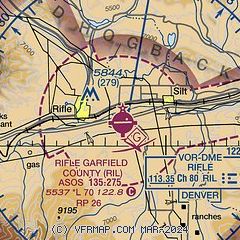
| Sectional chart |
|---|
|
CAUTION: Diagram may not be current

| Airport distance calculator |
|---|
|
|
| Sunrise and sunset |
|---|
|
Times for 18-Dec-2025
| | Local
(UTC-7) | | Zulu
(UTC) |
|---|
| Morning civil twilight | | 06:57 | | 13:57 |
| Sunrise | | 07:27 | | 14:27 |
| Sunset | | 16:48 | | 23:48 |
| Evening civil twilight | | 17:18 | | 00:18 |
|
| Current date and time |
|---|
| Zulu (UTC) | 19-Dec-2025 05:52:23 |
|---|
| Local (UTC-7) | 18-Dec-2025 22:52:23 |
|---|
|
| METAR |
|---|
| KRIL | 190453Z AUTO 00000KT 10SM CLR 02/M09 A3011 RMK AO2 SLP205 T00171089
|
K5SM
17nm E | 190512Z AUTO 10SM OVC022 M03/M12 A3018 RMK AO2
|
|
| TAF |
|---|
| KRIL | 190226Z 1902/1924 14003KT P6SM BKN070 FM190600 00000KT P6SM SCT070 FM192100 23008KT P6SM FEW120
|
|
| NOTAMs |
|---|
NOTAMs are issued by the DoD/FAA and will open in a separate window not controlled by AirNav.
|
|


