FAA INFORMATION EFFECTIVE 15 MAY 2025
Location
| FAA Identifier: | RPX |
| Lat/Long: | 46-28-30.0000N 108-32-36.3000W
46-28.500000N 108-32.605000W
46.4750000,-108.5434167
(estimated) |
| Elevation: | 3490.3 ft. / 1063.8 m (surveyed) |
| Variation: | 11E (2015) |
| From city: | 2 miles N of ROUNDUP, MT |
| Time zone: | UTC -6 (UTC -7 during Standard Time) |
| Zip code: | 59072 |
Airport Operations
| Airport use: | Open to the public |
| Activation date: | 04/1940 |
| Control tower: | no |
| ARTCC: | SALT LAKE CITY CENTER |
| FSS: | GREAT FALLS FLIGHT SERVICE STATION |
| NOTAMs facility: | GTF (NOTAM-D service available) |
| Attendance: | UNATNDD |
| Wind indicator: | lighted |
| Segmented circle: | yes |
| Lights: | ACTVT MIRL RY 07/25 AND PAPI RY 07 & RY 25 - 122.7. |
| Beacon: | white-green (lighted land airport)
Operates sunset to sunrise. |
Airport Communications
- APCH/DEP CTL SVC PRVDD BY SALT LAKE ARTCC (ZLC) ON 126.85/305.2 (MILES CITY RCAG).
Airport Services
| Fuel available: | 100LL JET-A1
100LL:CREDIT CARD SELF SVC FUEL AVBL 24/7. |
| Parking: | hangars and tiedowns |
| Airframe service: | MAJOR |
| Powerplant service: | MAJOR |
| Bottled oxygen: | NONE |
| Bulk oxygen: | NONE |
Runway Information
Runway 7/25
| Dimensions: | 5099 x 75 ft. / 1554 x 23 m |
| Surface: | asphalt, in excellent condition |
| Weight bearing capacity: | |
| Runway edge lights: | medium intensity |
| RUNWAY 7 | | RUNWAY 25 |
| Latitude: | 46-28.416097N | | 46-28.594168N |
| Longitude: | 108-33.081697W | | 108-31.895452W |
| Elevation: | 3490.3 ft. | | 3430.8 ft. |
| Traffic pattern: | left | | left
RY 25 RIGHT TFC FM 2200 TO 0700. |
| Runway heading: | 067 magnetic, 078 true | | 247 magnetic, 258 true |
| Markings: | nonprecision, in good condition | | nonprecision, in good condition |
| Visual slope indicator: | 2-light PAPI on left (4.00 degrees glide path) | | 2-light PAPI on left (3.00 degrees glide path) |
| Touchdown point: | yes, no lights | | yes, no lights |
| Obstructions: | 17 ft. gnd, 700 ft. from runway, 29:1 slope to clear | | none |
Runway 16/34
| Dimensions: | 2460 x 100 ft. / 750 x 30 m |
| Surface: | turf, in good condition |
| Runway edge markings: | RY 16/34 MKD WITH WHITE CONES FULL LENGTH; RED CONES MARK THR. |
| RUNWAY 16 | | RUNWAY 34 |
| Latitude: | 46-28.686903N | | 46-28.291565N |
| Longitude: | 108-32.904995W | | 108-32.780455W |
| Elevation: | 3462.2 ft. | | 3482.3 ft. |
| Traffic pattern: | left | | left |
| Runway heading: | 157 magnetic, 168 true | | 337 magnetic, 348 true |
| Touchdown point: | yes, no lights | | yes, no lights |
Airport Ownership and Management from official FAA records
| Ownership: | Publicly-owned |
| Owner: | ROUNDUP & MUSSELSHELL COUNTY
506 MAIN ST
ROUNDUP, MT 59072
Phone 406-323-1104 |
| Manager: | KELLY GEBHARDT
20 SKYLINE DRIVE
ROUNDUP, MT 59072
Phone 406-323-1564
OR 406-855-7354 CONTACT FOR SVCS |
Additional Remarks
| A96 | ULTRALIGHTS ON & INVOF ARPT. |
| - | PHONE ON FLD. |
| - | WILDLIFE ON & INVOF ARPT. |
| - | FOR CD CTC BILLINGS APCH AT 406-255-2798. |
Instrument Procedures
NOTE: All procedures below are presented as PDF files. If you need a reader for these files, you should download the free Adobe Reader.NOT FOR NAVIGATION. Please procure official charts for flight.
FAA instrument procedures published for use from 15 May 2025 at 0901Z to 13 June 2025 at 0900z.
IAPs - Instrument Approach Procedures |
|---|
| RNAV (GPS) RWY 07 | |
download (209KB) |
| RNAV (GPS) RWY 25 | |
download (186KB) |
| NOTE: Special Take-Off Minimums/Departure Procedures apply | |
download (214KB) |
Other nearby airports with instrument procedures:
KBIL - Billings Logan International Airport (40 nm S)
6S8 - Laurel Municipal Airport (47 nm S)
KLWT - Lewistown Municipal Airport (51 nm NW)
KHWQ - Wheatland County Airport at Harlowton (54 nm W)
00U - Big Horn County Airport (57 nm SE)
|
|

Road maps at:
MapQuest
Bing
Google
| Aerial photo |
|---|
WARNING: Photo may not be current or correct
 Photo taken 25-Aug-2007
looking southwest
Photo taken 25-Aug-2007
looking southwest
Do you have a better or more recent aerial photo of Roundup Airport that you would like to share? If so, please send us your photo.
|
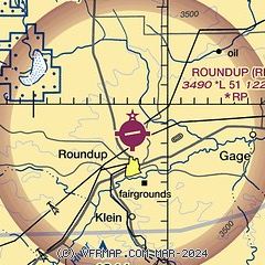
| Sectional chart |
|---|
|
| Airport distance calculator |
|---|
|
|
| Sunrise and sunset |
|---|
|
Times for 17-May-2025
| | Local
(UTC-6) | | Zulu
(UTC) |
|---|
| Morning civil twilight | | 05:03 | | 11:03 |
| Sunrise | | 05:39 | | 11:39 |
| Sunset | | 20:42 | | 02:42 |
| Evening civil twilight | | 21:18 | | 03:18 |
|
| Current date and time |
|---|
| Zulu (UTC) | 17-May-2025 18:47:05 |
|---|
| Local (UTC-6) | 17-May-2025 12:47:05 |
|---|
|
| TAF |
|---|
KBIL
41nm S | 171731Z 1718/1818 11007KT P6SM FEW070 BKN120 FM180200 09014KT P6SM VCSH SCT100 BKN120 PROB30 1804/1808 -SHRA FM181100 03008KT P6SM VCSH SCT060 BKN100
|
|
| NOTAMs |
|---|
NOTAMs are issued by the DoD/FAA and will open in a separate window not controlled by AirNav.
|
|


