FAA INFORMATION EFFECTIVE 14 MAY 2026
Location
| FAA Identifier: | SMD |
| Lat/Long: | 41-08-36.1000N 085-09-10.0000W
41-08.601667N 085-09.166667W
41.1433611,-85.1527778
(estimated) |
| Elevation: | 835.7 ft. / 254.7 m (surveyed) |
| Variation: | 05W (2000) |
| From city: | 4 miles N of FORT WAYNE, IN |
| Time zone: | UTC -4 (UTC -5 during Standard Time) |
| Zip code: | 46825 |
Airport Operations
| Airport use: | Open to the public |
| Activation date: | 04/1940 |
| Control tower: | no |
| ARTCC: | CHICAGO CENTER |
| FSS: | TERRE HAUTE FLIGHT SERVICE STATION |
| NOTAMs facility: | HUF (NOTAM-D service available) |
| Attendance: | 5 NOV-9 MAR 0700-1900, 10 MAR-4 NOV 0700-2100
AFT HR - 260-747-2624. |
| Wind indicator: | lighted |
| Segmented circle: | no |
| Lights: | ACTVT PAPI RWY 05; MIRL RWY 05/23 & 13/31 - CTAF. |
| Beacon: | white-green (lighted land airport)
Operates sunset to sunrise. |
Airport Communications
| CTAF/UNICOM: | 122.8 |
| WX AWOS-3: | 124.55 (260-490-4030) |
| FORT WAYNE APPROACH: | 127.2 ;SW/NW OF ACTIVE RWY 132.15 ;SE/NE OF ACTIVE RWY [0600-2300] |
| FORT WAYNE DEPARTURE: | 127.2 ;SW/NW OF ACTIVE RWY 132.15 ;SE/NE OF ACTIVE RWY [0600-2300] |
| IC: | 127.2 ;SW/NW OF ACTIVE RWY |
| WX ASOS at FWA (10 nm S): | PHONE 260-209-0224 |
| WX AWOS-3P at GWB (11 nm NE): | 124.15 (260-925-8225) |
- APCH CTL SECTORIZATION BASED UPON FORT WAYNE RWY USAGE.
Nearby radio navigation aids
| VOR radial/distance | | VOR name | | Freq | | Var |
|---|
| FWAr015/10.0 | | FORT WAYNE VORTAC | | 117.80 | | 06W |
| OLKr115/(16.8) | | WEBSTER LAKE VOR | | 110.40 | | 03W |
| NDB name | | Hdg/Dist | | Freq | | Var | | ID |
|---|
| SHENK | | 229/13.7 | | 227 | | 05W | | GW | --. .-- |
Airport Services
| Fuel available: | 100LL JET-A
100LL:SELF SVC AVBL. |
| Parking: | tiedowns |
| Airframe service: | MAJOR |
| Powerplant service: | MAJOR |
Runway Information
Runway 5/23
| Dimensions: | 3126 x 100 ft. / 953 x 30 m |
| Surface: | asphalt, in good condition |
| Weight bearing capacity: | |
| Runway edge lights: | medium intensity |
| Operational restrictions: | RWY 23 CALM WIND RWY. |
| RUNWAY 5 | | RUNWAY 23 |
| Latitude: | 41-08.453715N | | 41-08.779635N |
| Longitude: | 085-09.427780W | | 085-08.900783W |
| Elevation: | 827.0 ft. | | 828.0 ft. |
| Traffic pattern: | left | | left |
| Runway heading: | 056 magnetic, 051 true | | 236 magnetic, 231 true |
| Displaced threshold: | 201 ft. | | 91 ft. |
| Markings: | nonprecision, in good condition | | nonprecision, in good condition |
| Visual slope indicator: | 2-light PAPI on left (4.00 degrees glide path)
PAPI RSTRD BYD 7 DEGS LEFT & RIGHT OF CNTRLN. | | 2-light PAPI on left (3.05 degrees glide path)
PAPI UNUSBL BYD 7 DEGS LEFT & RIGHT OF CNTRLN. |
| Runway end identifier lights: | no | | no |
| Touchdown point: | yes, no lights | | yes, no lights |
| Obstructions: | 10 ft. crops, 200 ft. from runway
10 FT CROPS 65 FT FM RWY END & 90 FT E & 115 FT W. | | 15 ft. road, 200 ft. from runway, 175 ft. right of centerline
15 FT ROAD 185 FT FM RWY END 175 FT R. |
Runway 13/31
| Dimensions: | 2922 x 60 ft. / 891 x 18 m |
| Surface: | asphalt, in excellent condition |
| Weight bearing capacity: | |
| Runway edge lights: | medium intensity |
| Operational restrictions: | 75 FT CROPS EACH SIDE OF CNTRLN. |
| RUNWAY 13 | | RUNWAY 31 |
| Latitude: | 41-08.735473N | | 41-08.438582N |
| Longitude: | 085-09.420792W | | 085-08.919923W |
| Elevation: | 832.4 ft. | | 825.4 ft. |
| Traffic pattern: | left | | left |
| Runway heading: | 133 magnetic, 128 true | | 313 magnetic, 308 true |
| Displaced threshold: | 299 ft. | | 101 ft. |
| Markings: | nonprecision, in good condition | | nonprecision, in good condition |
| Runway end identifier lights: | no | | no |
| Touchdown point: | yes, no lights | | yes, no lights |
| Obstructions: | 60 ft. tree, 1171 ft. from runway, 270 ft. right of centerline, 16:1 slope to clear
10 FT CROPS 60 FT FM RWY END | | 15 ft. road, 200 ft. from runway, 200 ft. left of centerline
15 FT ROAD 215 FT FM RWY END 185 FT L. |
Airport Ownership and Management from official FAA records
| Ownership: | Publicly-owned |
| Owner: | FT WAYNE ALLEN CO APT ATHRTY
3801 W FERGUSON ROAD-RM 209
FT WAYNE, IN 46809
Phone 260-747-4146 |
| Manager: | SCOTT D. HINDERMAN, A.A.E.
3801 WEST FERGUSON ROAD, STE. 209
FORT WAYNE, IN 46809
Phone 260-747-4146 |
Additional Remarks
| - | COND UNMNT NOV-MAR 1900-0700. |
| - | COLD TEMPERATURE AIRPORT. ALTITUDE CORRECTION REQUIRED AT OR BELOW -21C. |
| - | 100 FT FLD LGTS 0.5 NM E. |
| - | BIRDS ON & INVOF ARPT. |
| - | FOR CD CTC CHICAGO ARTCC AT 630-906-8921. |
Instrument Procedures
NOTE: All procedures below are presented as PDF files. If you need a reader for these files, you should download the free Adobe Reader.NOT FOR NAVIGATION. Please procure official charts for flight.
FAA instrument procedures published for use from 14 May 2026 at 0901Z to 11 June 2026 at 0900Z.
IAPs - Instrument Approach Procedures |
|---|
| RNAV (GPS) RWY 05 | |
download (218KB) |
| RNAV (GPS) RWY 13 | |
download (256KB) |
| RNAV (GPS) RWY 23 | |
download (207KB) |
| RNAV (GPS) RWY 31 | |
download (225KB) |
| NOTE: Special Take-Off Minimums/Departure Procedures apply | |
download (457KB) |
Other nearby airports with instrument procedures:
KFWA - Fort Wayne International Airport (10 nm S)
KGWB - Auburn/Dekalb Executive Airport (11 nm NE)
C62 - Kendallville Municipal Airport (20 nm N)
KHHG - Huntington Municipal Airport (22 nm SW)
KVNW - Van Wert County Airport (30 nm SE)
|
|

Road maps at:
MapQuest
Bing
Google
| Aerial photo |
|---|
WARNING: Photo may not be current or correct
 Photo courtesy of Todd Stemen / Advantage Aerial Inc.
Photo taken 12-Sep-2011
looking west.
Photo courtesy of Todd Stemen / Advantage Aerial Inc.
Photo taken 12-Sep-2011
looking west.
Do you have a better or more recent aerial photo of Smith Field Airport that you would like to share? If so, please send us your photo.
|
| Sectional chart |
|---|
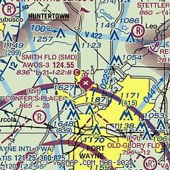
|
| Airport distance calculator |
|---|
|
|
| Sunrise and sunset |
|---|
|
Times for 08-Jun-2026
| | Local
(UTC-4) | | Zulu
(UTC) |
|---|
| Morning civil twilight | | 05:36 | | 09:36 |
| Sunrise | | 06:09 | | 10:09 |
| Sunset | | 21:10 | | 01:10 |
| Evening civil twilight | | 21:44 | | 01:44 |
|
| Current date and time |
|---|
| Zulu (UTC) | 08-Jun-2026 22:51:38 |
|---|
| Local (UTC-4) | 08-Jun-2026 18:51:38 |
|---|
|
| METAR |
|---|
| KSMD | 082235Z AUTO 20010KT 10SM CLR 29/21 A3004 RMK A01
|
KGWB
11nm N | 082235Z AUTO VRB04KT 10SM FEW042 SCT050 BKN080 28/22 A3002 RMK AO2
|
KFWA
11nm S | 082154Z 19015G20KT 10SM -RA SCT036 BKN075 OVC200 27/21 A3005 RMK AO2 RAB53 SLP171 P0000 T02670211 $
|
|
| TAF |
|---|
KFWA
11nm S | 082032Z 0821/0918 17011KT P6SM VCSH SCT025 BKN050 TEMPO 0822/0901 4SM -TSRA BR OVC025CB FM090900 15007KT 4SM -SHRA BR BKN009 FM091600 21010KT P6SM BKN020
|
|
| NOTAMs |
|---|
NOTAMs are issued by the DoD/FAA and will open in a separate window not controlled by AirNav.
|
|

