FAA INFORMATION EFFECTIVE 14 MAY 2026
Location
| FAA Identifier: | SXU |
| Lat/Long: | 34-56-08.4195N 104-38-33.2295W
34-56.140325N 104-38.553825W
34.9356721,-104.6425638
(estimated) |
| Elevation: | 4791.4 ft. / 1460 m (estimated) |
| Variation: | 10E (1990) |
| From city: | 3 miles E of SANTA ROSA, NM |
| Time zone: | UTC -6 (UTC -7 during Standard Time) |
| Zip code: | 88435 |
Airport Operations
| Airport use: | Open to the public |
| Activation date: | 05/1967 |
| Control tower: | no |
| ARTCC: | ALBUQUERQUE CENTER |
| FSS: | ALBUQUERQUE FLIGHT SERVICE STATION |
| NOTAMs facility: | ABQ (NOTAM-D service available) |
| Attendance: | UNATNDD |
| Wind indicator: | lighted |
| Segmented circle: | yes |
| Lights: | ACTVT MIRL RWY 01/19 & 08/26 PRESET MED INTST DUSK-2200; INCR INTST CTAF. AFT 2200 ACTVT - CTAF. |
| Beacon: | white-green (lighted land airport)
Operates sunset to sunrise. |
Airport Communications
| CTAF/UNICOM: | 122.8 |
| WX AWOS-3PT: | 118.1 (575-472-9943) |
Nearby radio navigation aids
| VOR radial/distance | | VOR name | | Freq | | Var |
|---|
| ACHr106/22.2 | | ANTON CHICO VORTAC | | 117.80 | | 12E |
Airport Services
| Fuel available: | 100LL JET-A1+
100LL:AVBL H24 WITH CREDIT CARD. |
| Parking: | hangars and tiedowns |
Runway Information
Runway 1/19
| Dimensions: | 5013 x 75 ft. / 1528 x 23 m |
| Surface: | asphalt, in good condition |
| Weight bearing capacity: | | PCN 5 /F/D/Y/T | | Single wheel: | 12.5 |
|
| Runway edge lights: | medium intensity |
| Operational restrictions: | +5 FT BERM W OF CNTRLN NEAR RWY 19 TOUCHDOWN BARS. |
| RUNWAY 1 | | RUNWAY 19 |
| Latitude: | 34-55.569917N | | 34-56.338633N |
| Longitude: | 104-38.603317W | | 104-38.235200W |
| Elevation: | 4779.0 ft. | | 4791.4 ft. |
| Traffic pattern: | left | | left |
| Runway heading: | 012 magnetic, 022 true | | 192 magnetic, 202 true |
| Markings: | nonprecision, in good condition | | nonprecision, in good condition |
| Visual slope indicator: | | | 2-light PAPI on left (2.45 degrees glide path) |
| Touchdown point: | yes, no lights | | yes, no lights |
Runway 8/26
| Dimensions: | 4294 x 60 ft. / 1309 x 18 m |
| Surface: | asphalt, in fair condition |
| Weight bearing capacity: | | PCN 5 /F/C/Y/T | | Single wheel: | 11.5 |
|
| Runway edge lights: | medium intensity |
| RUNWAY 8 | | RUNWAY 26 |
| Latitude: | 34-56.349750N | | 34-56.365217N |
| Longitude: | 104-39.140583W | | 104-38.281200W |
| Elevation: | 4766.6 ft. | | 4784.2 ft. |
| Traffic pattern: | left | | left |
| Runway heading: | 079 magnetic, 089 true | | 259 magnetic, 269 true |
| Markings: | nonprecision, in good condition | | nonprecision, in good condition |
| Visual slope indicator: | | | 2-light PAPI on left (3.36 degrees glide path) |
| Touchdown point: | yes, no lights | | yes, no lights |
Airport Ownership and Management from official FAA records
| Ownership: | Publicly-owned |
| Owner: | TOWN OF SANTA ROSA
244 S 5TH ST
SANTA ROSA, NM 88435
Phone 575-472-3404 |
| Manager: | ANTHONY SENA
244 S 5TH ST
SANTA ROSA, NM 88435
Phone 575-799-2296
EMERG - POLICE 575-472-3605. |
Additional Remarks
| A58-01 | +3 FT BRUSH 0-130 FT FM THR 10 FT R & 80 FT L. |
| A58-08 | +10 FT ACES ROAD 10-200 FT FM RWY END ON CNTRLN; 2-3 FT BRUSH 20-200 FT FM RWY END 40-125 FT L & 50-125 FT R OF CNTRLN. |
| - | WILDLIFE ON & INVOF ARPT. |
| - | GATE ACES - 9942. |
| - | FOR CD CTC ALBUQUERQUE ARTCC AT 505-856-4861. |
Instrument Procedures
There are no published instrument procedures at KSXU.
Some nearby airports with instrument procedures:
KLVS - Las Vegas Municipal Airport (50 nm NW)
KTCC - Tucumcari Municipal Airport (53 nm E)
0E0 - Moriarty Municipal Airport (67 nm W)
KCVS - Cannon Air Force Base (73 nm SE)
KPRZ - Portales Municipal Airport (77 nm SE)
|
|

Road maps at:
MapQuest
Bing
Google
| Aerial photo |
|---|
WARNING: Photo may not be current or correct

Do you have a better or more recent aerial photo of Santa Rosa Route 66 Airport that you would like to share? If so, please send us your photo.
|
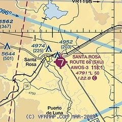
| Sectional chart |
|---|
|
| Airport distance calculator |
|---|
|
|
| Sunrise and sunset |
|---|
|
Times for 30-May-2026
| | Local
(UTC-6) | | Zulu
(UTC) |
|---|
| Morning civil twilight | | 05:19 | | 11:19 |
| Sunrise | | 05:48 | | 11:48 |
| Sunset | | 20:05 | | 02:05 |
| Evening civil twilight | | 20:34 | | 02:34 |
|
| Current date and time |
|---|
| Zulu (UTC) | 30-May-2026 15:56:16 |
|---|
| Local (UTC-6) | 30-May-2026 09:56:16 |
|---|
|
| METAR |
|---|
| KSXU | 301535Z AUTO 27016G26KT 10SM CLR 23/M06 A2996 RMK AO2 PK WND 26026/06
|
|
| NOTAMs |
|---|
NOTAMs are issued by the DoD/FAA and will open in a separate window not controlled by AirNav.
|
|


