FAA INFORMATION EFFECTIVE 16 APRIL 2026
Location
| FAA Identifier: | UKI |
| Lat/Long: | 39-07-33.4000N 123-12-03.1000W
39-07.556667N 123-12.051667W
39.1259444,-123.2008611
(estimated) |
| Elevation: | 616.8 ft. / 188.0 m (surveyed) |
| Variation: | 13E (2025) |
| From city: | 1 mile S of UKIAH, CA |
| Time zone: | UTC -7 (UTC -8 during Standard Time) |
| Zip code: | 95482 |
Airport Operations
| Airport use: | Open to the public |
| Activation date: | 04/1946 |
| Control tower: | no |
| ARTCC: | OAKLAND CENTER |
| FSS: | OAKLAND FLIGHT SERVICE STATION |
| NOTAMs facility: | UKI (NOTAM-D service available) |
| Attendance: | JUN SAT-SUN 0930-2000, JUL-AUG MON-FRI 0800-2030, JUL-AUG SAT-SUN 1000-2030, SEP MON-FRI 0800-2000, SEP SAT-SUN 0930-2000, OCT 0800-1930, NOV 0800-1800, DEC-APR 0800-1730, MAY MON-FRI 0800-1930, MAY SAT-SUN 0930-1930, JUN MON-FRI 0800-2000 |
| Wind indicator: | lighted |
| Segmented circle: | yes |
| Lights: | ACTVT PAPI RWY 15; REIL RWY 15 & 33; MIRL RWY 15/33 - CTAF. |
| Beacon: | white-green (lighted land airport)
SECOND ROTATING BCN ON MTN 250 DEGREES MAGNETIC & 2 MILES FM ARPT. DUSK-DAWN |
| Landing fee: | yes, LNDG FEE FOR ALL ACFT OVR 12500 LBS. |
Airport Communications
| CTAF/UNICOM: | 123.0 |
| WX ASOS: | 119.275 (707-462-7343) |
| WX AWOS-3 at 1O2 (16 nm SE): | 118.35 (707-262-0380) |
- APCH/DEP CTL SVC PRVDD BY OAKLAND ARTCC (ZOA) ON FREQS 127.8/353.5 (UKIAH RCAG).
Nearby radio navigation aids
| VOR radial/distance | | VOR name | | Freq | | Var |
|---|
| ENIr022/5.5 | | MENDOCINO VORTAC | | 112.30 | | 16E |
Airport Services
| Fuel available: | 100LL JET-A
100LL:SELF-SERVICE FUEL AVBL. |
| Parking: | tiedowns |
| Airframe service: | MAJOR |
| Powerplant service: | MAJOR |
| Bottled oxygen: | NONE |
| Bulk oxygen: | HIGH |
Runway Information
Runway 15/33
| Dimensions: | 4423 x 150 ft. / 1348 x 46 m |
| Surface: | asphalt, in excellent condition |
| Weight bearing capacity: | |
| Runway edge lights: | medium intensity |
| RUNWAY 15 | | RUNWAY 33 |
| Latitude: | 39-07.913900N | | 39-07.200410N |
| Longitude: | 123-12.146167W | | 123-11.956987W |
| Elevation: | 616.8 ft. | | 604.7 ft. |
| Traffic pattern: | left | | right |
| Runway heading: | 155 magnetic, 168 true | | 335 magnetic, 348 true |
| Markings: | nonprecision, in good condition | | basic, in good condition |
| Visual slope indicator: | 4-light PAPI on left (3.00 degrees glide path) | | |
| Runway end identifier lights: | yes | | yes |
| Touchdown point: | yes, no lights | | yes, no lights |
| Instrument approach: | LOC/DME | | |
| Obstructions: | 27 ft. trees, 950 ft. from runway, 190 ft. right of centerline, 27:1 slope to clear | | 27 ft. trees, 700 ft. from runway, 135 ft. left of centerline, 18:1 slope to clear |
Airport Ownership and Management from official FAA records
| Ownership: | Publicly-owned |
| Owner: | CITY OF UKIAH
300 SEMINARY AV
UKIAH, CA 95482
Phone 707-467-2855 |
| Manager: | GREG OWEN
1403 S. STATE STREET
UKIAH, CA 95482
Phone 707-467-2855 |
Additional Remarks
| - | NO JET ACFT DEPARTURES BETWEEN 2200-0700 LCL. |
| - | CALM WIND RWY IS 15 FOR NOISE ABATEMENT REASONS. |
| - | NOISE ABATEMENT PROCEDURES: AMGR REQUESTS NO VFR STRAIGHT-IN APCHS TO RY 15/33, RIGHT TURN AFTER DEP RY 33 TO AVOID OVERFLIGHT OF TOWN. |
| - | FOR CD IF UNA TO CTC ON FSS FREQ, CTC OAKLAND ARTCC AT 510-745-3380. |
Instrument Procedures
NOTE: All procedures below are presented as PDF files. If you need a reader for these files, you should download the free Adobe Reader.NOT FOR NAVIGATION. Please procure official charts for flight.
FAA instrument procedures published for use from 16 April 2026 at 0901Z to 14 May 2026 at 0900Z.
IAPs - Instrument Approach Procedures |
|---|
| RNAV (GPS) RWY 15 | |
download (427KB) |
| RNAV (GPS)-B | |
download (315KB) |
| LOC RWY 15 | |
download (408KB) |
| VOR-A | |
download (267KB) |
| NOTE: Special Alternate Minimums apply | |
download (137KB) |
Departure Procedures |
|---|
| RONHU TWO (RNAV) | |
download (186KB) |
| RYPAX TWO (RNAV) | |
download (157KB) |
| NOTE: Special Take-Off Minimums/Departure Procedures apply | |
download (347KB) |
Other nearby airports with instrument procedures:
1O2 - Lampson Field Airport (16 nm SE)
O28 - Willits Municipal Airport - Ells Field (21 nm N)
O60 - Cloverdale Municipal Airport (23 nm SE)
KLLR - Little River Airport (27 nm W)
KHES - Healdsburg Municipal Airport (32 nm SE)
|
|

Road maps at:
MapQuest
Bing
Google
| Aerial photo |
|---|
WARNING: Photo may not be current or correct
 Photo courtesy of Dick Jones, RJ Aerial Photo
Photo taken 13-Sep-2005
Photo courtesy of Dick Jones, RJ Aerial Photo
Photo taken 13-Sep-2005
Do you have a better or more recent aerial photo of Ukiah Municipal Airport that you would like to share? If so, please send us your photo.
|
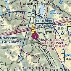
| Sectional chart |
|---|
|
CAUTION: Diagram may not be current

| Airport distance calculator |
|---|
|
|
| Sunrise and sunset |
|---|
|
Times for 26-Apr-2026
| | Local
(UTC-7) | | Zulu
(UTC) |
|---|
| Morning civil twilight | | 05:53 | | 12:53 |
| Sunrise | | 06:22 | | 13:22 |
| Sunset | | 20:00 | | 03:00 |
| Evening civil twilight | | 20:28 | | 03:28 |
|
| Current date and time |
|---|
| Zulu (UTC) | 26-Apr-2026 11:54:16 |
|---|
| Local (UTC-7) | 26-Apr-2026 04:54:16 |
|---|
|
| METAR |
|---|
| KUKI | 261121Z AUTO 04005KT 10SM SCT025 SCT032 OVC041 11/07 A2981 RMK AO2 T01060067
|
|
| TAF |
|---|
| KUKI | 260557Z 2606/2706 30002KT P6SM OVC025 FM261300 02003KT P6SM SCT030 FM262000 34008KT P6SM SCT040 FM270300 35003KT P6SM SKC
|
|
| NOTAMs |
|---|
NOTAMs are issued by the DoD/FAA and will open in a separate window not controlled by AirNav.
|
|


