FAA INFORMATION EFFECTIVE 25 DECEMBER 2025
Location
| FAA Identifier: | UNK |
| Lat/Long: | 63-53-18.6000N 160-47-56.8000W
63-53.310000N 160-47.946667W
63.8885000,-160.7991111
(estimated) |
| Elevation: | 27.3 ft. / 8.3 m (surveyed) |
| Variation: | 11E (2020) |
| From city: | 1 mile N of UNALAKLEET, AK |
| Time zone: | UTC -9 (UTC -8 during Daylight Saving Time) |
| Zip code: | 99684 |
Airport Operations
| Airport use: | Open to the public |
| Control tower: | no |
| ARTCC: | ANCHORAGE CENTER |
| FSS: | NOME FLIGHT SERVICE STATION [ 443-2291 (local call from the AIRPORT)] |
| Alternate FSS: | FAI FAIRBANKS FLIGHT SERVICE STATION [1-866-248-6516] |
| NOTAMs facility: | UNK (NOTAM-D service available) |
| Attendance: | MON-FRI 0800-1600 |
| Wind indicator: | yes |
| Segmented circle: | yes |
| Lights: | ACTVT REIL RWY 33; HIRL RWY 15/33; MIRL RWY 09/27 - CTAF. VASI RWY 15 & 33 ON CONSLY. |
| Beacon: | white-green (lighted land airport)
Operates sunset to sunrise. |
Airport Communications
| CTAF: | 123.0 |
| WX AWOS-3P: | 132.25 (907-624-3051) |
- APCH/DEP SVC PRVDD BY ANCHORAGE ARTCC ON FREQS 135.7/335.5 (UNALAKLEET RCAG).
- COMMUNICATIONS PRVDD BY NOME FSS ON FREQ 122.30 (UNALAKLEET RCO).
Nearby radio navigation aids
| VOR radial/distance | | VOR name | | Freq | | Var |
|---|
| UNKr251/3.0 | | UNALAKLEET VOR/DME | | 116.90 | | 15E |
Airport Services
| Fuel available: | 100LL JET-A |
| Parking: | tiedowns |
| Airframe service: | EMERG ONLY. |
| Powerplant service: | EMERG ONLY. |
Runway Information
Runway 15/33
| Dimensions: | 5900 x 150 ft. / 1798 x 46 m |
| Surface: | asphalt/grooved, in good condition |
| Runway edge lights: | high intensity |
| RUNWAY 15 | | RUNWAY 33 |
| Latitude: | 63-53.880425N | | 63-52.949343N |
| Longitude: | 160-48.361430W | | 160-47.761173W |
| Elevation: | 25.7 ft. | | 24.7 ft. |
| Traffic pattern: | right | | left |
| Runway heading: | 153 magnetic, 164 true | | 333 magnetic, 344 true |
| Markings: | precision, in good condition | | precision, in good condition |
| Visual slope indicator: | 4-box VASI on left (3.00 degrees glide path) | | 4-box VASI on left (3.00 degrees glide path) |
| Runway end identifier lights: | no | | yes |
| Touchdown point: | yes, no lights | | yes, no lights |
| Instrument approach: | LOC/DME | | |
| Obstructions: | 15 ft. road, 200 ft. from runway, 110 ft. left of centerline | | 25 ft. bldg, 850 ft. from runway, 300 ft. right of centerline, 26:1 slope to clear |
Runway 9/27
| Dimensions: | 1900 x 75 ft. / 579 x 23 m |
| Surface: | asphalt/grooved, in good condition |
| Weight bearing capacity: | |
| Runway edge lights: | medium intensity |
| RUNWAY 9 | | RUNWAY 27 |
| Latitude: | 63-53.006827N | | 63-52.961993N |
| Longitude: | 160-47.941243W | | 160-47.241408W |
| Elevation: | 24.1 ft. | | 19.3 ft. |
| Traffic pattern: | left | | left |
| Runway heading: | 087 magnetic, 098 true | | 267 magnetic, 278 true |
| Markings: | basic, in good condition | | basic, in good condition |
| Touchdown point: | yes, no lights | | yes, no lights |
| Obstructions: | none | | 20 ft. brdg, 690 ft. from runway, 310 ft. left of centerline, 24:1 slope to clear |
Airport Ownership and Management from official FAA records
| Ownership: | Publicly-owned |
| Owner: | ALASKA DOT&PF NORTHERN REGION
NORTHERN REGION, 2301 PEGER RD
FAIRBANKS, AK 99701
Phone 907-451-2200 |
| Manager: | JOHN WILSON
PO BOX 192
UNALAKLEET, AK 99684
Phone 907-625-1025
EMAIL: JOHN.WILSON@ALASKA.GOV |
Additional Remarks
| A30A-15 | 100 FT UNLGT TWR 0.4 NM N OF THR. |
| - | 299 FT TWR 2.4 NM E. |
| - | SNOW REMOVAL & DEICING NA 1600-0800. |
| - | RWY COND UNMNT; RCMD VISUAL INSP PRIOR TO LNDG. |
| - | WX CAMERA AVBL ON INTERNET AT HTTPS://WEATHERCAMS.FAA.GOV. |
Instrument Procedures
NOTE: All procedures below are presented as PDF files. If you need a reader for these files, you should download the free Adobe Reader.NOT FOR NAVIGATION. Please procure official charts for flight.
FAA instrument procedures published for use from 25 December 2025 at 0901z to 22 January 2026 at 0900z.
IAPs - Instrument Approach Procedures |
|---|
| RNAV (GPS) RWY 33 **CHANGED** | |
download (218KB) |
| RNAV (GPS)-A **CHANGED** | |
download (153KB) |
| LOC RWY 15 **CHANGED** | |
download (233KB) |
| NOTE: Special Alternate Minimums apply | |
download (161KB) |
|
|---|
| UNALAKLEET ONE (OBSTACLE) | |
2 pages:
[1] [2] (492KB) |
| NOTE: Special Take-Off Minimums/Departure Procedures apply | |
download (245KB) |
Other nearby airports with instrument procedures:
PFSH - Shaktoolik Airport (31 nm N)
PAMK - St Michael Airport (42 nm SW)
PFEL - Elim Airport (58 nm NW)
PAKV - Kaltag Airport (60 nm NE)
PAGX - Grayling Airport (63 nm S)
|
|

Road maps at:
MapQuest
Bing
Google
| Aerial photo |
|---|
WARNING: Photo may not be current or correct
 Photo by Vicki Eifert
Photo taken 20-Jun-2018
looking northeast.
Photo by Vicki Eifert
Photo taken 20-Jun-2018
looking northeast.
Do you have a better or more recent aerial photo of Unalakleet Airport that you would like to share? If so, please send us your photo.
|
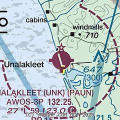
| Sectional chart |
|---|
|
| Airport distance calculator |
|---|
|
|
| Sunrise and sunset |
|---|
|
Times for 05-Jan-2026
| | Local
(UTC-9) | | Zulu
(UTC) |
|---|
| Morning civil twilight | | 10:15 | | 19:15 |
| Sunrise | | 11:27 | | 20:27 |
| Sunset | | 16:11 | | 01:11 |
| Evening civil twilight | | 17:23 | | 02:23 |
|
| Current date and time |
|---|
| Zulu (UTC) | 05-Jan-2026 14:05:54 |
|---|
| Local (UTC-9) | 05-Jan-2026 05:05:54 |
|---|
|
| METAR |
|---|
| PAUN | 051356Z AUTO 06032G40KT 10SM CLR M22/M28 A2903 RMK AO2 PK WND 06040/1355 SLP834 T12171278 FZRANO
|
|
| TAF |
|---|
| PAUN | 051132Z 0512/0612 08025G45KT 4SM BR SKC FM051500 07020G35KT 4SM BR SKC FM060000 05015KT P6SM SKC
|
|
| NOTAMs |
|---|
NOTAMs are issued by the DoD/FAA and will open in a separate window not controlled by AirNav.
|
|

