FAA INFORMATION EFFECTIVE 27 NOVEMBER 2025
Location
| FAA Identifier: | NYL |
| Lat/Long: | 32-39-23.6660N 114-36-21.5540W
32-39.394433N 114-36.359233W
32.6565739,-114.6059872
(estimated) |
| Elevation: | 213.3 ft. / 65.0 m (surveyed) |
| Variation: | 13E (2000) |
| From city: | 3 miles S of YUMA, AZ |
| Time zone: | UTC -7 (year round; does not observe DST) |
| Zip code: | 85365 |
Airport Operations
| Airport use: | Open to the public |
| Activation date: | 04/1940 |
| Control tower: | yes |
| ARTCC: | LOS ANGELES CENTER |
| FSS: | PRESCOTT FLIGHT SERVICE STATION |
| NOTAMs facility: | NYL (NOTAM-D service available) |
| Attendance: | ALL/ALL/
MIL AVN OPS NA 1430-1500Z DLY. VAL/TRANS SVC ABVL MON-FRI 1500-0600Z, CLSD SAT-SUN, HOL. |
| Pattern altitude: | TPA RWY 03L/R RIGHT TRAFFIC 1700 FT; RWY 21L/R LEFT TRAFFIC 1700FT. INITIAL ALT FOR OVERHEAD 4000 FT 6NM. INITIAL ALT FOR STRAIGHT-IN 3000 FT 6NM. COPTER - 700 FT FOR ANY RWY. |
| Wind indicator: | lighted |
| Segmented circle: | no |
| Lights: | WHEN ATCT CLSD ACTVT HIRL RWY 08/26 & 17/35; TWYS A, A1, A2, B, C, L, Z - CTAF. |
| Beacon: | white-green (lighted land airport)
Operates sunset to sunrise. |
| Fire and rescue: | ARFF index A |
| International operations: | international airport of entry |
Airport Communications
| CTAF: | 119.3 |
| UNICOM: | 122.95 |
| ATIS: | 118.8 273.5 |
| YUMA GROUND: | 121.9 314.0 [1430-0600Z DLY, CLSD HOL. MIL AVN OPS NOT AUTHORIZED 1430-1500Z DLY DUE TO AFLD MAINT.] |
| YUMA TOWER: | 119.3 377.075 [1430-0600Z DLY, CLSD HOL. MIL AVN OPS NOT AUTHORIZED 1430-1500Z DLY DUE TO AFLD MAINT.] |
| ALCP: | 337.9 |
| COMD POST: | 377.9 |
| EMERG: | 121.5 243.0 |
| PMSV METRO: | 120.7 120.725 349.75 |
- APCH CTL SVC PRVVD BY YUMA CERAP ON 124.7/371.975 (YUMA RCAG). DEP CTL SVC PRVDD BY YUMA CERAP ON 125.5/282.325 (YUMA/A RCAG).
- PMSV AVBL MON-FRI 1400-2330Z.
Nearby radio navigation aids
| VOR radial/distance | | VOR name | | Freq | | Var |
|---|
| BZAr167/6.7 | | BARD VORTAC | | 116.80 | | 14E |
Airport Services
| Fuel available: | 100 JET-A JET-A+
100:ON CALL H24. |
| Parking: | tiedowns |
| Airframe service: | MINOR |
| Powerplant service: | MINOR |
| Bottled oxygen: | HIGH/LOW |
| Bulk oxygen: | HIGH/LOW |
Runway Information
Runway 3L/21R
| Dimensions: | 13300 x 200 ft. / 4054 x 61 m |
| Surface: | concrete, in good condition |
| Weight bearing capacity: | | PCN 58 /R/C/W/T | | Single wheel: | 103.0 | | Double wheel: | 200.0 | | Double tandem: | 400.0 |
|
| Runway edge lights: | high intensity |
| RUNWAY 3L | | RUNWAY 21R |
| Latitude: | 32-38.206950N | | 32-39.781600N |
| Longitude: | 114-37.763700W | | 114-35.959133W |
| Elevation: | 192.6 ft. | | 192.7 ft. |
| Traffic pattern: | right | | left |
| Runway heading: | 031 magnetic, 044 true | | 211 magnetic, 224 true |
| Declared distances: | TORA:13300 TODA:13300 ASDA:13300 LDA:13300 | | TORA:13300 TODA:13300 ASDA:13300 LDA:13300 |
| Markings: | precision, in good condition | | precision, in good condition |
| Visual slope indicator: | 4-light PAPI on left (3.00 degrees glide path) | | 4-light PAPI on left (3.00 degrees glide path) |
| Approach lights: | | | MALSR: 1,400 foot medium intensity approach lighting system with runway alignment indicator lights |
| Runway end identifier lights: | yes | | |
| Touchdown point: | yes, no lights | | yes, no lights |
| Instrument approach: | | | ILS |
Runway 3R/21L
| Dimensions: | 9240 x 150 ft. / 2816 x 46 m |
| Surface: | asphalt/concrete, in good condition |
| Weight bearing capacity: | | PCN 48 /R/C/W/T | | Single wheel: | 162.0 | | Double wheel: | 200.0 | | Double tandem: | 400.0 |
|
| Runway edge lights: | high intensity |
| RUNWAY 3R | | RUNWAY 21L |
| Latitude: | 32-38.924333N | | 32-40.017983N |
| Longitude: | 114-36.751733W | | 114-35.497600W |
| Elevation: | 188.0 ft. | | 207.6 ft. |
| Traffic pattern: | right | | left |
| Runway heading: | 031 magnetic, 044 true | | 211 magnetic, 224 true |
| Declared distances: | TORA:9240 TODA:9240 ASDA:9240 LDA:9240 | | TORA:9240 TODA:9240 ASDA:9240 LDA:9240 |
| Markings: | nonprecision, in good condition | | nonprecision, in good condition |
| Visual slope indicator: | 4-light PAPI on left (3.00 degrees glide path) | | 4-light PAPI on left (3.00 degrees glide path) |
| Runway end identifier lights: | yes | | yes |
| Touchdown point: | yes, no lights | | yes, no lights |
| Obstructions: | 29 ft. ant, lighted, 650 ft. from runway, 300 ft. left of centerline, 15:1 slope to clear | | 18 ft. road, 1250 ft. from runway |
Runway 8/26
| Dimensions: | 6146 x 150 ft. / 1873 x 46 m |
| Surface: | asphalt, in good condition |
| Weight bearing capacity: | | PCN 46 /F/B/W/T | | Single wheel: | 63.0 | | Double wheel: | 137.0 | | Double tandem: | 206.0 |
|
| Runway edge lights: | high intensity |
| RUNWAY 8 | | RUNWAY 26 |
| Latitude: | 32-39.954033N | | 32-39.969417N |
| Longitude: | 114-36.339367W | | 114-35.141267W |
| Elevation: | 194.7 ft. | | 213.3 ft. |
| Traffic pattern: | right | | left |
| Runway heading: | 076 magnetic, 089 true | | 256 magnetic, 269 true |
| Declared distances: | TORA:6146 TODA:6146 ASDA:6146 LDA:6146 | | TORA:6146 TODA:6146 ASDA:6146 LDA:6146 |
| Markings: | basic, in good condition | | basic, in good condition |
| Runway end identifier lights: | no | | no |
| Touchdown point: | yes, no lights | | yes, no lights |
| Obstructions: | 15 ft. road, 490 ft. from runway, 19:1 slope to clear
18 FT WINDSOCK 130 FT L OF RWY END. | | 14 ft. road, 1250 ft. from runway |
Runway 17/35
| Dimensions: | 5710 x 150 ft. / 1740 x 46 m |
| Surface: | asphalt/concrete, in good condition |
| Weight bearing capacity: | | PCN 58 /R/C/W/T | | Single wheel: | 72.0 | | Double wheel: | 171.0 | | Double tandem: | 255.0 |
|
| Runway edge lights: | high intensity |
| RUNWAY 17 | | RUNWAY 35 |
| Latitude: | 32-40.062483N | | 32-39.120942N |
| Longitude: | 114-36.243817W | | 114-36.226783W |
| Elevation: | 196.3 ft. | | 182.5 ft. |
| Traffic pattern: | right | | left |
| Runway heading: | 166 magnetic, 179 true | | 346 magnetic, 359 true |
| Declared distances: | TORA:5710 TODA:5710 ASDA:5710 LDA:5710 | | TORA:5710 TODA:5710 ASDA:5710 LDA:5710 |
| Markings: | nonprecision, in good condition | | nonprecision, in good condition |
| Visual slope indicator: | 4-light PAPI on left (3.00 degrees glide path) | | |
| Runway end identifier lights: | no | | yes |
| Touchdown point: | yes, no lights | | yes, no lights |
| Obstructions: | 72 ft. tree, 1980 ft. from runway, 150 ft. left of centerline, 24:1 slope to clear
17 FT WINDSOCK 140 FT L 100 FT FM END. | | 4 ft. brush, 300 ft. from runway, 120 ft. left of centerline, 25:1 slope to clear
14 FT WINDSOCK 110 FT L 90 FT FM RWY END . |
Airport Ownership and Management from official FAA records
| Ownership: | U.S. Navy |
| Owner: | USMC & YUMA CO ARPT AUTH
2356 E O'NEILL ST, BLDG 153
YUMA, AZ 85369-9114
Phone 928-269-3327 |
| Manager: | GREGORY MCSHANE
2356 E O'NEILL ST, BLDG 153
YUMA, AZ 85369-9114
Phone 928-269-3327
ALT: 928-726-5882. MIL APCH SUPERVISOR - 928-269-2326. |
Additional Remarks
| E60-03R | HOOK E28(B) (2725 FT) |
| E60-03L | HOOK E28(B) (3495 FT) |
| E60-21R | HOOK E28(B) (1699 FT) |
| E60-21L | HOOK E28(B) (1675 FT) |
| - | CTN: JOINT USE CIVIL/MIL ARPT; GEN AVN & ACR OPR VFR ENTER ATA AT 1200 FT WHEN ASGN RWY 08/26 OR 17/35. |
| - | HEL ENTER ARPT TFC AREA AT TFC PAT ALT 1200 FT THEN DESCEND TO 700 FT PRIOR TO ALL RWYS. |
| - | PART 77 OBSTRNS-RADAR TWR E, POLES NEAR RWY 17. |
| - | CTN: TFC PAT RWY 03L/R & 21L/R OVERLAP TFC PAT RWY 08/26 & 17/35. |
| - | JASU: 1(NC-10) 1(NCPP-105) |
| - | FLUID: LOX LHNIT LPOX |
| - | FUEL - F-24(MIL)-AVBL O/R FOR SHIPBOUND ACFT. F-24(MIL). A, A+ (FBO: 928-247-9571; 131.225, AVBL MON-FRI 1300-0400Z, SAT-SUN 1300-0100Z, OT 1 HR MIN PN). (NC-100). |
| - | OIL - O-156 |
| - | RSTD: FLT CLNC MANNED DURG MIL OPS HR - D269-2326/2323/2077, C928-269-2326/2323/2077. TSNT 24 HR PPR - D269-2445/2760, C928-269-2445/2760. AV8B VSTOL TRNG TO RWY 03/21 MAY HAVE PRIORITY MON-FRI OVER MIL PRAC APCH. |
| - | MIL USE: ILS RADAR; SEE TERMINAL FLIP FOR RADAR MINIMA. |
| - | 976 FT STWY RWY 03R; 1000 FT STWY RWY 21L; 1000 FT STWY RWY 03L; 1000 FT STWY RWY 21R; 1000 FT STWY RWY 08; 251 FT STWY RWY 26; 800 FT STWY RWY 17; 262 FT STWY RWY 35. |
| - | 24 HR PPR FOR ALL TSNT FR VAL C928-269-2445, D269-2445. 24 HR PPR ALL TSNT UTILIZING MIL RAMP; D951-2445/2760, C928-269-2445/2760. MIL ACFT REQ TO RWY 03/21 MAY HAVE PRIORITY MON-SAT OVER PRACTICE APCHS. |
| - | MILITARY USE: VHF/DF |
| - | MISC: AMBULANCE OPS BTN 0500-1300Z NEEDING GND ACCESS - CIVIL ARPT AUTH C928-941-2396 OR 376-5868. |
| - | US CUSTOMS PORT OF ENTRY - 928-344-9572 OR 928- 314-1295. |
| - | CIVIL ARPT OPS - 928-726-5882 EXTN 2161 OR 928-941-2396 |
| - | TWY A2 PCN 33/F/B/W/T, TWY K PCN 30/G/B/W/T, TWY L PCN 33/F/B/W/T, TWY Z PCN 33/F/B/W/T |
| - | ROTARY WING ACFT RECOVERY NA TO VTOL PAD-4. |
| - | CTN: AVOID OVFT MEXICAN BORDER 7 NM W, JET TRNG OPS INVOF. HIGH VOLUME LCL AREA OPS ON UHF; VHF OPS EXER CTN & STRICT COMPLIANCE TO ATC INSTR. |
| - | AVOID OVFT OF MCAS YUMA INFRASTRUCTURE E OF MAIN APRON. |
| - | OPS HR APPLIES TO MIL INCLG YUMA INTL & FBO; AFT HR TWO WEEK PPR IN WRITING - 928-269-3327/D269-3327. |
| - | FOD RSTRN: HVY/WIDE BODY ARR/DEP RWY 03L/21R ONLY; MCAS YUMA S MAIN PRKG APN/VAL BACK TAX RWY 03L/21R THEN TWY D; YUMA INTL/MILLION AIR YUMA FBO DEF CONTRR CMPLX PRKG APN BACK TAX RWY 03L/21R THEN TWY H1 OR F1. OTR RWY OR TWY NA. HVY/WIDE BODY ENG RUNUPS ON RWY NA EXC USAF 1/2. |
| - | ARFF NA AFT OPS HR EXC SKED PART 121 ACR. |
| - | FOR CD CTC YUMA CERAP AT 928-269-9569. |
| - | F/W, R/W & F35 RAPID RFL HOT PIT AVBL DURG ATCT HR WITH 24 HR PPR - 928-247-9571 OR 131.225; 2 ACFT SIMUL OPS AVBL; ADZ ATC & PROCD TO S RAMP OFF TWY Z3. |
| - | MCAS BASE OPS - D269-7050/2077. MIL OPS 1430-0600Z DLY; CLSD HOL. |
| - | GEN AVN & ACR VFR DEP FLY RWY HDG MNTN 1200 FT UNTIL OUTSIDE ATA UNLESS OTRW APVD BY TWR. |
| - | MIL JET OPS FM 4000-3000 FT MSL DESCENDING TO 1700 FT MSL WI 6 NM SW STRAIGHT-IN RWY 03L & 03R & WI 6 NM NE STRAIGHT-IN RWY 21R & 21L. |
Instrument Procedures
NOTE: All procedures below are presented as PDF files. If you need a reader for these files, you should download the free Adobe Reader.NOT FOR NAVIGATION. Please procure official charts for flight.
FAA instrument procedures published for use from 27 November 2025 at 0901Z to 25 December 2025 at 0900Z.
IAPs - Instrument Approach Procedures |
|---|
| ILS OR LOC/DME RWY 21R | |
download (155KB) |
| RNAV (GPS) RWY 03L | |
download (118KB) |
| RNAV (GPS) RWY 17 | |
download (95KB) |
| RNAV (GPS) RWY 21R | |
download (110KB) |
| VOR/DME OR TACAN RWY 17 | |
download (136KB) |
| VOR RWY 17 | |
download (125KB) |
| HI-TACAN Z RWY 03L | |
download (159KB) |
| HI-TACAN Z RWY 21R | |
download (163KB) |
| TACAN Y RWY 03L | |
download (141KB) |
| TACAN Y RWY 21R | |
download (143KB) |
| Radar Approach Procedures available | |
download (192KB) |
Departure Procedures |
|---|
| ARGUS FIVE | |
download (113KB) |
| CARGO ONE | |
2 pages:
[1] [2] (195KB) |
| HEEDS THREE | |
download (128KB) |
| MOHAK FIVE | |
download (110KB) |
| PICACHO FIVE | |
download (111KB) |
| NOTE: Special Take-Off Minimums/Departure Procedures apply | |
download (357KB) |
Other nearby airports with instrument procedures:
KLGF - Laguna Army Airfield (Yuma Proving Ground) (16 nm NE)
KBWC - Brawley Municipal Airport (50 nm NW)
KIPL - Imperial County Airport (50 nm W)
KCLR - Cliff Hatfield Memorial Airport (54 nm NW)
KNJK - El Centro NAF Airport (Vraciu Field) (55 nm W)
|
|

Road maps at:
MapQuest
Bing
Google
| Aerial photo |
|---|
WARNING: Photo may not be current or correct
 Photo by Rudy Maldonado
Photo taken 23-Sep-2017
looking southwest.
Photo by Rudy Maldonado
Photo taken 23-Sep-2017
looking southwest.
Do you have a better or more recent aerial photo of Yuma Marine Corps Air Station/Yuma International Airport that you would like to share? If so, please send us your photo.
|
| Sectional chart |
|---|
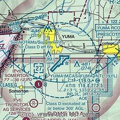
|
CAUTION: Diagram may not be current
 Download PDF
of official airport diagram from the FAA
| Airport distance calculator |
|---|
|
|
| Sunrise and sunset |
|---|
|
Times for 15-Dec-2025
| | Local
(UTC-7) | | Zulu
(UTC) |
|---|
| Morning civil twilight | | 07:07 | | 14:07 |
| Sunrise | | 07:34 | | 14:34 |
| Sunset | | 17:33 | | 00:33 |
| Evening civil twilight | | 18:00 | | 01:00 |
|
| Current date and time |
|---|
| Zulu (UTC) | 16-Dec-2025 06:41:08 |
|---|
| Local (UTC-7) | 15-Dec-2025 23:41:08 |
|---|
|
| METAR |
|---|
| KNYL | 160557Z AUTO A3003 RMK AO2 SLPNO 53003 PWINO TSNO $
|
KNOZ
12nm SE | 160559Z AUTO A3004 RMK AO2 SLPNO 53003 PWINO TSNO $
|
KLGF
16nm NE | 160555Z AUTO 36003KT 10SM CLR 14/01 A3003 RMK AO2 SLP169 T01430005 10252 20140 50007 $
|
|
| TAF |
|---|
| KNYL | 1603/1703 32004KT 9999 SKC QNH3001INS BECMG 1610/1612 34006KT 9999 SKC QNH3001INS BECMG 1622/1700 36006KT 9999 SKC QNH2997INS FM170200 34004KT 9999 SKC QNH2998INS TX27/1622Z TN14/1613Z
|
|
| NOTAMs |
|---|
NOTAMs are issued by the DoD/FAA and will open in a separate window not controlled by AirNav.
|
|


