FAA INFORMATION EFFECTIVE 27 NOVEMBER 2025
Location
| FAA Identifier: | C29 |
| Lat/Long: | 43-06-51.5880N 089-31-53.9360W
43-06.859800N 089-31.898933W
43.1143300,-89.5316489
(estimated) |
| Elevation: | 928 ft. / 282.9 m (surveyed) |
| Variation: | 01W (2000) |
| From city: | 5 miles NW of MIDDLETON, WI |
| Time zone: | UTC -6 (UTC -5 during Daylight Saving Time) |
| Zip code: | 53562 |
Airport Operations
| Airport use: | Open to the public |
| Activation date: | 09/1948 |
| Control tower: | no |
| ARTCC: | CHICAGO CENTER |
| FSS: | GREEN BAY FLIGHT SERVICE STATION |
| NOTAMs facility: | GRB (NOTAM-D service available) |
| Attendance: | 0800-1730 |
| Wind indicator: | lighted |
| Segmented circle: | no |
| Lights: | MIRL RWY 10/28 PRESET TO LOW SS-SR; TO INCR INTST & ACTVT REIL RWY 10 & 28; MIRL RWY 10/28 - CTAF. |
| Beacon: | white-green (lighted land airport)
Operates sunset to sunrise. |
Airport Communications
| CTAF/UNICOM: | 123.0 |
| WX AWOS-3: | 118.675 (608-833-1686) |
| MADISON APPROACH: | 135.45 [0600-2300] |
| MADISON DEPARTURE: | 135.45 [0600-2300] |
| WX ASOS at MSN (9 nm E): | PHONE 608-410-1285 |
- APCH/DEP SVC PRVDD BY CHICAGO ARTCC ON FREQS 133.3/257.925 (LONE ROCK RCAG) WHEN MADISON APCH CTL CLSD.
Nearby radio navigation aids
| VOR radial/distance | | VOR name | | Freq | | Var |
|---|
| MSNr255/8.6 | | MADISON VORTAC | | 108.60 | | 03E |
| DLLr156/28.1 | | DELLS VORTAC | | 117.00 | | 03E |
| JVLr328/38.3 | | JANESVILLE VOR/DME | | 114.30 | | 03E |
| NDB name | | Hdg/Dist | | Freq | | Var | | ID |
|---|
| ROCK RIVER | | 265/35.5 | | 371 | | 01W | | RYV | .-. -.-- ...- |
Airport Services
| Fuel available: | 100LL JET-A+ |
| Parking: | hangars and tiedowns |
| Airframe service: | MAJOR |
| Powerplant service: | MAJOR |
| Bottled oxygen: | NONE |
| Bulk oxygen: | HIGH/LOW |
Runway Information
Runway 10/28
| Dimensions: | 4001 x 100 ft. / 1220 x 30 m |
| Surface: | asphalt, in fair condition |
| Runway edge lights: | medium intensity |
| RUNWAY 10 | | RUNWAY 28 |
| Latitude: | 43-06.891977N | | 43-06.781640N |
| Longitude: | 089-32.438878W | | 089-31.552763W |
| Elevation: | 927.9 ft. | | 926.8 ft. |
| Traffic pattern: | left | | left |
| Runway heading: | 101 magnetic, 100 true | | 281 magnetic, 280 true |
| Markings: | nonprecision, in fair condition | | nonprecision, in fair condition |
| Visual slope indicator: | 2-light PAPI on left (4.00 degrees glide path) | | 2-light PAPI on left (4.00 degrees glide path) |
| Runway end identifier lights: | yes | | yes |
| Touchdown point: | yes, no lights | | yes, no lights |
| Instrument approach: | LOC/DME | | |
Runway 1/19
| Dimensions: | 1780 x 120 ft. / 543 x 37 m |
| Surface: | turf, in good condition |
| Runway edge markings: | MKD WITH YELLOW CONES. |
| RUNWAY 1 | | RUNWAY 19 |
| Latitude: | 43-06.766150N | | 43-07.056713N |
| Longitude: | 089-31.707118W | | 089-31.655287W |
| Elevation: | 926.1 ft. | | 927.6 ft. |
| Traffic pattern: | left | | left |
| Runway heading: | 008 magnetic, 007 true | | 188 magnetic, 187 true |
| Markings: | NSTD, in fair condition | | NSTD, in fair condition |
| Touchdown point: | yes, no lights | | yes, no lights |
Airport Ownership and Management from official FAA records
| Ownership: | Publicly-owned |
| Owner: | CITY OF MIDDLETON
7426 HUBBARD AVENUE
MIDDLETON, WI 53562
Phone 608-827-1050 |
| Manager: | RICHARD MOREY
8300 AIRPORT ROAD, 7426 HUBBARD AVE
MIDDLETON, WI 53562
Phone 608-836-1711 |
Additional Remarks
| - | FOR CD CTC MADISON APP/DEP CON AT 608-249-8240. WHEN MADISON APCH CLSD, FOR CD CTC CHICAGO ARTCC AT 630-906-8921. |
| - | RWY 01/19 CLSD FM NOV 01 THRU APR 30. |
| - | BIRDS ON & INVOF ARPT. |
| - | AVOID NOISE SENSITIVE AREA 1 MI SW; SEE CITY OR MOREY CO WEBSITES FOR DETAILS. |
Instrument Procedures
NOTE: All procedures below are presented as PDF files. If you need a reader for these files, you should download the free Adobe Reader.NOT FOR NAVIGATION. Please procure official charts for flight.
FAA instrument procedures published for use from 27 November 2025 at 0901Z to 25 December 2025 at 0900Z.
IAPs - Instrument Approach Procedures |
|---|
| RNAV (GPS) RWY 10 | |
download (273KB) |
| RNAV (GPS) RWY 28 | |
download (253KB) |
| LOC/DME RWY 10 | |
download (254KB) |
| VOR RWY 28 | |
download (256KB) |
| NOTE: Special Alternate Minimums apply | |
download (161KB) |
| NOTE: Special Take-Off Minimums/Departure Procedures apply | |
download (483KB) |
Other nearby airports with instrument procedures:
KMSN - Dane County Regional Airport-Truax Field (9 nm E)
91C - Sauk/Prairie Airport (15 nm NW)
87Y - Blackhawk Airfield (15 nm E)
KDLL - Baraboo/Wisconsin Dells Regional Airport (27 nm NW)
C47 - Portage Municipal Airport (27 nm N)
|
|

Road maps at:
MapQuest
Bing
Google
| Aerial photo |
|---|
WARNING: Photo may not be current or correct
 Photo by Sue Golden
Photo taken 12-Oct-2008
Photo by Sue Golden
Photo taken 12-Oct-2008
Do you have a better or more recent aerial photo of Middleton Municipal Airport - Morey Field that you would like to share? If so, please send us your photo.
|
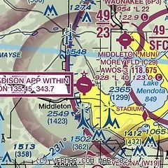
| Sectional chart |
|---|
|
| Airport distance calculator |
|---|
|
|
| Sunrise and sunset |
|---|
|
Times for 01-Dec-2025
| | Local
(UTC-6) | | Zulu
(UTC) |
|---|
| Morning civil twilight | | 06:39 | | 12:39 |
| Sunrise | | 07:11 | | 13:11 |
| Sunset | | 16:23 | | 22:23 |
| Evening civil twilight | | 16:55 | | 22:55 |
|
| Current date and time |
|---|
| Zulu (UTC) | 01-Dec-2025 17:44:52 |
|---|
| Local (UTC-6) | 01-Dec-2025 11:44:52 |
|---|
|
| METAR |
|---|
| KC29 | 011735Z AUTO 19004KT 10SM BKN031 BKN060 OVC080 M05/M06 A3027 RMK AO1 T10501062
|
KMSN
8nm E | 011730Z 19004KT 10SM FEW065 OVC080 M05/M08 A3027 RMK AO2 SNE30 P0000 T10501083
|
|
| TAF |
|---|
KMSN
8nm E | 011454Z 0115/0212 VRB03KT P6SM BKN150 FM011800 20005KT P6SM OVC022 FM012000 20005KT 5SM -SN OVC024 FM012200 VRB04KT 3SM -SN OVC012 TEMPO 0122/0124 2SM -SN OVC010 FM020100 VRB04KT P6SM OVC008 FM020300 VRB04KT P6SM OVC012
|
|
| NOTAMs |
|---|
NOTAMs are issued by the DoD/FAA and will open in a separate window not controlled by AirNav.
|
|


