FAA INFORMATION EFFECTIVE 18 APRIL 2024
Location
| FAA Identifier: | DHN |
| Lat/Long: | 31-19-15.7000N 085-26-58.1000W
31-19.261667N 085-26.968333W
31.3210278,-85.4494722
(estimated) |
| Elevation: | 400.8 ft. / 122.2 m (surveyed) |
| Variation: | 03W (2010) |
| From city: | 5 miles NW of DOTHAN, AL |
| Time zone: | UTC -5 (UTC -6 during Standard Time) |
| Zip code: | 36350 |
Airport Operations
| Airport use: | Open to the public |
| Activation date: | 07/1942 |
| Control tower: | yes |
| ARTCC: | JACKSONVILLE CENTER |
| FSS: | ANNISTON FLIGHT SERVICE STATION |
| NOTAMs facility: | DHN (NOTAM-D service available) |
| Attendance: | CONTINUOUS |
| Wind indicator: | lighted |
| Segmented circle: | yes |
| Lights: | WHEN ATCT CLSD, ACTVT MALSR RWY 32; REIL RWY 14; PAPI RWY 14; HIRL RWY 14/32 - CTAF. PAPI RWY 18; HIRL RWY 18/36 AVBL BY PRIOR REQ DURG ATNDD HRS, CALL 334-983-8100/8103. REIL RWY 18 OPR BY ATCT WHEN RWY 18 ACTV. |
| Beacon: | white-green (lighted land airport)
Operates sunset to sunrise. |
| Landing fee: | no, MISC: LDG FEE FOR PART 135 OPS. |
| Fire and rescue: | ARFF index A |
| Airline operations: | ARFF INDEX B AVAILABLE; 48 HR PPR FOR UNSKED ACR OPNS WITH MORE THAN 30 PSGR SEATS 2300-0600 CALL AMGR 334-983-8100. |
Airport Communications
| CTAF: | 118.4 |
| UNICOM: | 122.95 |
| ATIS: | 135.725 |
| WX ASOS: | PHONE 334-983-5999 |
| DOTHAN GROUND: | 121.7 348.6 [0600-2100 MON-FRI; 0800-2000 SAT & SUN.] |
| DOTHAN TOWER: | 118.4 257.6 [0600-2100 MON-FRI; 0800-2000 SAT & SUN.] |
| CAIRNS APPROACH: | 125.4 |
| CAIRNS DEPARTURE: | 125.4 |
| VFR ADZY: | 118.4 |
| WX AWOS-3PT at HDL (7 nm E): | 119.575 (334-693-0508) |
- APCH/DEP SVC PRVDD BY JACKSONVILLE ARTCC ON FREQS 134.3/322.55 (DOTHAN RCAG) WHEN CAIRNS APCH/DEP CLSD.
Nearby radio navigation aids
| VOR radial/distance | | VOR name | | Freq | | Var |
|---|
| RRSr335/2.4 | | WIREGRASS VORTAC | | 111.60 | | 02E |
| HEYr110/(10.9) | | HANCHEY VOR | | 110.60 | | 03W |
| OZRr081/14.5 | | CAIRNS VOR/DME | | 111.20 | | 03W |
| EDNr089/(23.3) | | ENTERPRISE VOR | | 116.60 | | 03W |
| MAIr332/36.2 | | MARIANNA VORTAC | | 114.00 | | 00E |
| NDB name | | Hdg/Dist | | Freq | | Var | | ID |
|---|
| LOWE | | 102/15.3 | | 269 | | 03W | | LOR | .-.. --- .-. |
| BOLL WEEVIL | | 095/27.3 | | 352 | | 03W | | BVG | -... ...- --. |
Airport Services
| Fuel available: | 100LL JET-A |
| Parking: | hangars and tiedowns |
| Airframe service: | MAJOR |
| Powerplant service: | MAJOR |
| Bottled oxygen: | NONE |
| Bulk oxygen: | NONE |
Runway Information
Runway 14/32
| Dimensions: | 8499 x 150 ft. / 2590 x 46 m |
| Surface: | asphalt/grooved, in good condition |
| Weight bearing capacity: | | PCN 34 /F/B/X/T | | Single wheel: | 75.0 | | Double wheel: | 105.0 | | Double tandem: | 190.0 |
|
| Runway edge lights: | high intensity |
| RUNWAY 14 | | RUNWAY 32 |
| Latitude: | 31-19.835353N | | 31-18.844943N |
| Longitude: | 085-27.698747W | | 085-26.542985W |
| Elevation: | 400.6 ft. | | 381.6 ft. |
| Traffic pattern: | left | | left |
| Runway heading: | 138 magnetic, 135 true | | 318 magnetic, 315 true |
| Declared distances: | TORA:8496 TODA:8496 ASDA:8496 LDA:8496 | | TORA:8496 TODA:8496 ASDA:8496 LDA:8496 |
| Markings: | precision, in good condition | | precision, in good condition |
| Visual slope indicator: | 2-light PAPI on left (3.00 degrees glide path) | | |
| RVR equipment: | rollout | | touchdown |
| Approach lights: | | | MALSR: 1,400 foot medium intensity approach lighting system with runway alignment indicator lights |
| Runway end identifier lights: | yes | | |
| Touchdown point: | yes, no lights | | yes, no lights |
| Instrument approach: | ILS/DME | | ILS |
Runway 18/36
| Dimensions: | 5498 x 100 ft. / 1676 x 30 m |
| Surface: | asphalt/grooved, in excellent condition |
| Weight bearing capacity: | | PCN 30 /F/B/X/T | | Single wheel: | 75.0 | | Double wheel: | 105.0 | | Double tandem: | 190.0 |
|
| Runway edge lights: | high intensity |
| RUNWAY 18 | | RUNWAY 36 |
| Latitude: | 31-19.592488N | | 31-18.685603N |
| Longitude: | 085-26.733603W | | 085-26.733453W |
| Elevation: | 394.7 ft. | | 378.4 ft. |
| Traffic pattern: | left | | left |
| Runway heading: | 183 magnetic, 180 true | | 003 magnetic, 360 true |
| Displaced threshold: | 499 ft. | | no |
| Declared distances: | TORA:5500 TODA:5500 ASDA:5500 LDA:5000 | | TORA:5000 TODA:5000 ASDA:5000 LDA:5000 |
| Markings: | nonprecision, in good condition | | nonprecision, in good condition |
| Visual slope indicator: | 4-light PAPI on left (3.00 degrees glide path) | | |
| Runway end identifier lights: | yes | | |
| Touchdown point: | yes, no lights | | yes, no lights |
| Obstructions: | 48 ft. trees, 1400 ft. from runway, 100 ft. left of centerline, 25:1 slope to clear | | 80 ft. trees, 2050 ft. from runway, 450 ft. left of centerline, 23:1 slope to clear |
Airport Ownership and Management from official FAA records
| Ownership: | Publicly-owned |
| Owner: | DOTHAN-HOUSTON CO ARPT AUTH
800 ARPT DR SUITE 15
DOTHAN, AL 36303
Phone 334-983-8100 |
| Manager: | ADAM HARTZOG
800 ARPT DR SUITE 15
DOTHAN, AL 36303
Phone 334-983-8108 |
Airport Operational Statistics
| Aircraft based on the field: | | 70 | | Single engine airplanes: | | 23 | | Multi engine airplanes: | | 28 | | Jet airplanes: | | 9 | | Military aircraft: | | 10 |
| |  | |
| Aircraft operations: avg 231/day * | | 60% | military | | 22% | transient general aviation | | 15% | local general aviation | | 2% | commercial | | 1% | air taxi | | * for 12-month period ending 31 October 2023 | |
Additional Remarks
| - | MAXI WID TWY A IS 75 FT FOR RWY 14/32. |
| - | RSTD: USAF NOT AUTH TO OPER C130 & C135 ACFT ON RWY 18/36. |
| - | ARFF PSNL ON DUTY AT ARPT 24 HRS. |
| - | FUEL A, A+ (C334 983 4541) (NC 100LL). |
| - | LN OF SIGHT FROM DOTHAN ATC TO A PTN OF TXY BRAVO BTN TXY ALPHA AND THE APCH END OF RWY 36 OBSTD BY THE AP BLDG. |
| - | FOR CD WHEN TWR CLSD IF UNA RDO, CTC CAIRNS APCH C334-255-8402. WHEN APCH CLSD CTC JACKSONVILLE ARTCC C904-845-1592. |
| - | APRON NORTH CLSD EXC MIL. 24 HR PPR OTRW 334-873-2408. |
Instrument Procedures
NOTE: All procedures below are presented as PDF files. If you need a reader for these files, you should download the free Adobe Reader.NOT FOR NAVIGATION. Please procure official charts for flight.
FAA instrument procedures published for use from 18 April 2024 at 0901Z to 16 May 2024 at 0900Z.
IAPs - Instrument Approach Procedures |
|---|
| ILS OR LOC RWY 14 | |
download (323KB) |
| ILS OR LOC RWY 32 | |
download (361KB) |
| RNAV (GPS) RWY 14 | |
download (222KB) |
| RNAV (GPS) RWY 18 | |
download (219KB) |
| RNAV (GPS) RWY 32 | |
download (231KB) |
| RNAV (GPS) RWY 36 | |
download (221KB) |
| VOR RWY 18 | |
download (178KB) |
| VOR OR TACAN RWY 14 | |
download (254KB) |
| VOR OR TACAN-A | |
download (211KB) |
| COPTER VOR RWY 36 | |
download (238KB) |
| NOTE: Special Alternate Minimums apply | |
download (155KB) |
| NOTE: Special Take-Off Minimums/Departure Procedures apply | |
download (189KB) |
Other nearby airports with instrument procedures:
KHDL - Headland Municipal Airport (7 nm E)
KHEY - Hanchey Army Heliport (Fort Novosel) (11 nm W)
71J - Ozark/Blackwell Field Airport (11 nm NW)
KOZR - Cairns Army Air Field (Fort Novosel) (14 nm W)
KLOR - Lowe Army Heliport (Fort Novosel) (16 nm W)
|
|

Road maps at:
MapQuest
Bing
Google
| Aerial photo |
|---|
WARNING: Photo may not be current or correct
 Taken in May 2007
Do you have a better or more recent aerial photo of Dothan Regional Airport that you would like to share? If so, please send us your photo.
|
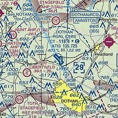
| Sectional chart |
|---|
|
CAUTION: Diagram may not be current
 Download PDF
of official airport diagram from the FAA
| Airport distance calculator |
|---|
|
|
| Sunrise and sunset |
|---|
|
Times for 24-Apr-2024
| | Local
(UTC-5) | | Zulu
(UTC) |
|---|
| Morning civil twilight | | 05:38 | | 10:38 |
| Sunrise | | 06:04 | | 11:04 |
| Sunset | | 19:16 | | 00:16 |
| Evening civil twilight | | 19:41 | | 00:41 |
|
| Current date and time |
|---|
| Zulu (UTC) | 24-Apr-2024 19:10:01 |
|---|
| Local (UTC-5) | 24-Apr-2024 14:10:01 |
|---|
|
| METAR |
|---|
| KDHN | 241853Z 34008KT 10SM CLR 27/11 A3016 RMK AO2 SLP207 T02670111
|
KHDL
7nm E | 241855Z AUTO 28005KT 3SM -RA HZ CLR 26/09 A3012 RMK AO2
|
KHEY
11nm W | 241855Z AUTO 23005KT 10SM CLR 26/22 A3009 RMK AO2 SLP190 T02630217
|
KOZR
14nm W | 241855Z AUTO 28008KT 10SM FEW190 27/11 A3011 RMK AO2 SLP197 T02650114 $
|
KLOR
15nm W | 241855Z AUTO 29004KT 10SM CLR 27/13 A3011 RMK AO2 SLP179 T02650129
|
|
| TAF |
|---|
| KDHN | 241720Z 2418/2518 28005KT P6SM SCT040 FM251400 03004KT P6SM SKC
|
KOZR
14nm W | 241800Z 2418/2524 VRB05KT 9999 SKC QNH3008INS BECMG 2421/2422 31006KT 9999 SCT040 QNH3009INS BECMG 2501/2502 VRB05KT 9999 BKN040 QNH3010INS TEMPO 2509/2512 8000 BR TX27/2420Z TN08/2511Z
|
|
| NOTAMs |
|---|
NOTAMs are issued by the DoD/FAA and will open in a separate window not controlled by AirNav.
|
|


