FAA INFORMATION EFFECTIVE 04 SEPTEMBER 2025
Location
| FAA Identifier: | CVO |
| Lat/Long: | 44-29-48.7530N 123-17-22.0460W
44-29.812550N 123-17.367433W
44.4968758,-123.2894572
(estimated) |
| Elevation: | 249.9 ft. / 76.2 m (surveyed) |
| Variation: | 15E (2020) |
| From city: | 4 miles SW of CORVALLIS, OR |
| Time zone: | UTC -7 (UTC -8 during Standard Time) |
| Zip code: | 97333 |
Airport Operations
| Airport use: | Open to the public |
| Activation date: | 12/1943 |
| Control tower: | no |
| ARTCC: | SEATTLE CENTER |
| FSS: | MC MINNVILLE FLIGHT SERVICE STATION |
| NOTAMs facility: | CVO (NOTAM-D service available) |
| Attendance: | 0800-DUSK |
| Pattern altitude: | 1049.9 ft. MSL |
| Wind indicator: | lighted |
| Segmented circle: | yes |
| Lights: | ACTVT MALSR RWY 17, REIL RWY 35; PAPI RWY 28; VASI RWY 17 & 35; HIRL RWY 17/35 & MIRL RWY 10/28 - CTAF. |
| Beacon: | white-green (lighted land airport)
Operates sunset to sunrise. |
Airport Communications
| CTAF/UNICOM: | 123.075 |
| WX AWOS-3PT: | 135.775 (541-754-0081) |
| CASCADE APPROACH: | 127.5 |
| CASCADE DEPARTURE: | 127.5 |
| WX AWOS-3PT at S12 (13 nm NE): | 119.925 (541-967-3508) |
- APCH/DEP CTL SVC PRVDD BY SEATTLE ARTCC (ZSE) ON FREQ 125.8/291.7 (HORTON RCAG) WHEN CASCADE APCH CTL (EUG) CLSD.
Nearby radio navigation aids
| VOR radial/distance | | VOR name | | Freq | | Var |
|---|
| CVO at field | | CORVALLIS VOR/DME | | 115.40 | | 18E |
| EUGr338/22.7 | | EUGENE VORTAC | | 112.90 | | 15E |
| ONPr083/33.3 | | NEWPORT VORTAC | | 117.10 | | 15E |
Airport Services
| Fuel available: | 100LL JET-A |
| Parking: | hangars and tiedowns |
| Airframe service: | MAJOR |
| Powerplant service: | MAJOR |
| Bottled oxygen: | HIGH |
| Bulk oxygen: | HIGH/LOW |
Runway Information
Runway 17/35
| Dimensions: | 5900 x 150 ft. / 1798 x 46 m |
| Surface: | asphalt, in good condition |
| Weight bearing capacity: | | Single wheel: | 35.0 | | Double wheel: | 73.0 | | Double tandem: | 100.0 |
|
| Runway edge lights: | high intensity |
| RUNWAY 17 | | RUNWAY 35 |
| Latitude: | 44-30.207133N | | 44-29.243338N |
| Longitude: | 123-17.464172W | | 123-17.628605W |
| Elevation: | 244.6 ft. | | 248.9 ft. |
| Traffic pattern: | left | | left |
| Runway heading: | 172 magnetic, 187 true | | 352 magnetic, 007 true |
| Declared distances: | TORA:5900 TODA:5900 ASDA:5900 LDA:5900 | | TORA:5900 TODA:5900 ASDA:5900 LDA:5900 |
| Markings: | precision, in fair condition | | nonprecision, in fair condition |
| Visual slope indicator: | 4-box VASI on left (3.00 degrees glide path) | | 4-box VASI on left (3.00 degrees glide path) |
| Approach lights: | MALSR: 1,400 foot medium intensity approach lighting system with runway alignment indicator lights | | |
| Runway end identifier lights: | | | yes |
| Touchdown point: | yes, no lights | | yes, no lights |
| Instrument approach: | ILS | | |
Runway 10/28
| Dimensions: | 3100 x 75 ft. / 945 x 23 m |
| Surface: | asphalt, in fair condition |
| Weight bearing capacity: | | Single wheel: | 51.0 | | Double wheel: | 65.0 | | Double tandem: | 100.0 |
|
| Runway edge lights: | medium intensity |
| Runway edge markings: | RWY 10/28 HAS WHITE SIDE STRIPES. |
| RUNWAY 10 | | RUNWAY 28 |
| Latitude: | 44-30.074140N | | 44-29.883275N |
| Longitude: | 123-17.357350W | | 123-16.696273W |
| Elevation: | 245.7 ft. | | 246.1 ft. |
| Traffic pattern: | left | | left |
| Runway heading: | 097 magnetic, 112 true | | 277 magnetic, 292 true |
| Displaced threshold: | no | | 228 ft. |
| Declared distances: | TORA:3100 TODA:3100 ASDA:3100 LDA:3100 | | TORA:3100 TODA:3100 ASDA:3100 LDA:2872 |
| Markings: | basic, in good condition | | basic, in good condition |
| Visual slope indicator: | | | 4-light PAPI on left (3.00 degrees glide path) |
| Touchdown point: | yes, no lights | | yes, no lights |
| Obstructions: | none | | 21 ft. rr, 380 ft. from runway, 8:1 slope to clear
APCH RATIO 29:1 FM DSPLCD THR. |
Airport Ownership and Management from official FAA records
| Ownership: | Publicly-owned |
| Owner: | CITY OF CORVALLIS
PUBLIC WORKS DEPT
CORVALLIS, OR 97339
Phone 541-766-6916 |
| Manager: | PAUL YAGER
PO BOX 1083
CORVALLIS, OR 97339-1083
Phone (541) 766-6783 |
Additional Remarks
| - | MIGRATORY WATERFOWL & OTR BIRDS ON & INVOF ARPT. |
| - | SURF COND NOT RPRT DLY 1700-0800 AND ALL TIMES SATURDAYS AND SUNDAYS. |
| - | FOR CD CTC CASCADE APCH AT 541-607-4674/4675, WHEN APCH CLSD CTC SEATTLE ARTCC AT 253-351-3694. |
Instrument Procedures
NOTE: All procedures below are presented as PDF files. If you need a reader for these files, you should download the free Adobe Reader.NOT FOR NAVIGATION. Please procure official charts for flight.
FAA instrument procedures published for use from 04 September 2025 at 0901Z to 02 October 2025 at 0900z.
IAPs - Instrument Approach Procedures |
|---|
| ILS OR LOC RWY 17 | |
download (303KB) |
| ILS OR LOC RWY 17 | |
download (303KB) |
| RNAV (GPS) RWY 17 | |
download (257KB) |
| RNAV (GPS) RWY 35 | |
download (243KB) |
| VOR RWY 17 | |
download (238KB) |
| VOR-A | |
download (183KB) |
| NOTE: Special Alternate Minimums apply | |
download (211KB) |
Departure Procedures |
|---|
| SHEDD FOUR | |
download (179KB) |
| NOTE: Special Take-Off Minimums/Departure Procedures apply | |
download (534KB) |
Other nearby airports with instrument procedures:
S12 - Albany Municipal Airport (13 nm NE)
KEUG - Mahlon Sweet Field Airport (23 nm S)
KSLE - McNary Field Airport (28 nm NE)
KONP - Newport Municipal Airport (33 nm W)
77S - Hobby Field Airport (36 nm S)
|
|

Road maps at:
MapQuest
Bing
Google
| Aerial photo |
|---|
WARNING: Photo may not be current or correct
 Photo by Jerry Wilken
Photo taken 22-Jun-2010
Photo by Jerry Wilken
Photo taken 22-Jun-2010
Do you have a better or more recent aerial photo of Corvallis Municipal Airport that you would like to share? If so, please send us your photo.
|
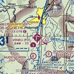
| Sectional chart |
|---|
|
CAUTION: Diagram may not be current

| Airport distance calculator |
|---|
|
|
| Sunrise and sunset |
|---|
|
Times for 18-Sep-2025
| | Local
(UTC-7) | | Zulu
(UTC) |
|---|
| Morning civil twilight | | 06:28 | | 13:28 |
| Sunrise | | 06:57 | | 13:57 |
| Sunset | | 19:18 | | 02:18 |
| Evening civil twilight | | 19:47 | | 02:47 |
|
| Current date and time |
|---|
| Zulu (UTC) | 19-Sep-2025 02:39:06 |
|---|
| Local (UTC-7) | 18-Sep-2025 19:39:06 |
|---|
|
| METAR |
|---|
| KCVO | 190156Z 33009KT 10SM CLR 22/13 A2991 RMK AO2 SLP132 T02220133
|
|
| TAF |
|---|
KEUG
22nm S | 181731Z 1818/1918 36009KT P6SM BKN018 FM181900 01016G23KT P6SM FEW018 SCT250 FM190100 36009KT P6SM BKN250 FM190800 35004KT P6SM SCT250
|
KSLE
27nm NE | 181731Z 1818/1918 36008KT P6SM SCT027 FM182000 36012G21KT P6SM SKC FM190100 36008KT P6SM FEW250
|
|
| NOTAMs |
|---|
NOTAMs are issued by the DoD/FAA and will open in a separate window not controlled by AirNav.
|
|


