FAA INFORMATION EFFECTIVE 16 APRIL 2026
Location
| FAA Identifier: | S12 |
| Lat/Long: | 44-38-16.1350N 123-03-34.0160W
44-38.268917N 123-03.566933W
44.6378153,-123.0594489
(estimated) |
| Elevation: | 226.5 ft. / 69.0 m (surveyed) |
| Variation: | 15E (2025) |
| From city: | 3 miles E of ALBANY, OR |
| Time zone: | UTC -7 (UTC -8 during Standard Time) |
| Zip code: | 97321 |
Airport Operations
| Airport use: | Open to the public |
| Activation date: | 01/1940 |
| Control tower: | no |
| ARTCC: | SEATTLE CENTER |
| FSS: | MC MINNVILLE FLIGHT SERVICE STATION |
| NOTAMs facility: | MMV (NOTAM-D service available) |
| Attendance: | 0800-1700 |
| Wind indicator: | lighted |
| Segmented circle: | yes |
| Lights: | ACTVT REIL RWY 16 & 34; PAPI RWY 16 & 34; MIRL RWY 16/34 - CTAF. |
| Beacon: | white-green (lighted land airport)
Operates sunset to sunrise. |
Airport Communications
| CTAF/UNICOM: | 122.725 |
| WX AWOS-3PT: | 119.925 (541-967-3508) |
| CASCADE APPROACH: | 127.5 |
| CASCADE DEPARTURE: | 127.5 |
| WX AWOS-3PT at CVO (13 nm SW): | 135.775 (541-754-0081) |
| WX ASOS at SLE (16 nm N): | 124.55 (458-322-0305) |
- APCH/DEP CTL SVC PRVDD BY SEATTLE ARTCC (ZSE) ON FREQ 125.8/291.7 (HORTON RCAG) WHEN CASCADE APCH CTL (EUG) CLSD.
Nearby radio navigation aids
| VOR radial/distance | | VOR name | | Freq | | Var |
|---|
| CVOr032/13.0 | | CORVALLIS VOR/DME | | 115.40 | | 18E |
| EUGr358/31.8 | | EUGENE VORTAC | | 112.90 | | 15E |
| NDB name | | Hdg/Dist | | Freq | | Var | | ID |
|---|
| TURNO | | 183/13.4 | | 266 | | 17E | | SL | ... .-.. |
Airport Services
| Fuel available: | 100LL |
| Parking: | tiedowns |
| Airframe service: | NONE |
| Powerplant service: | NONE |
| Bottled oxygen: | NONE |
Runway Information
Runway 16/34
| Dimensions: | 3004 x 75 ft. / 916 x 23 m |
| Surface: | asphalt, in good condition |
| Weight bearing capacity: | | Single wheel: | 30.0 | | Double wheel: | 43.0 | | Double tandem: | 71.0 |
|
| Runway edge lights: | medium intensity |
| RUNWAY 16 | | RUNWAY 34 |
| Latitude: | 44-38.516300N | | 44-38.021935N |
| Longitude: | 123-03.567338W | | 123-03.566345W |
| Elevation: | 225.8 ft. | | 226.3 ft. |
| Traffic pattern: | left | | left |
| Runway heading: | 165 magnetic, 180 true | | 345 magnetic, 360 true |
| Markings: | basic, in good condition | | basic, in good condition |
| Visual slope indicator: | 2-light PAPI on left (4.00 degrees glide path) | | 2-light PAPI on left (4.00 degrees glide path) |
| Runway end identifier lights: | yes | | yes |
| Touchdown point: | yes, no lights | | yes, no lights |
| Obstructions: | 13 ft. road, 427 ft. from runway, 148 ft. right of centerline, 17:1 slope to clear
RY 16 80 FT UNMARKED TREE AT 1530 FT ON CNTRLN AT 18:1. | | 80 ft. trees, 1520 ft. from runway, 16:1 slope to clear
65 FT MKD PLINE AT 1575 FT ON CNTRLN AT 20:1. |
Airport Ownership and Management from official FAA records
| Ownership: | Publicly-owned |
| Owner: | CITY OF ALBANY
P O BOX 490
ALBANY, OR 97321
Phone 541-917-7600 |
| Manager: | ROBB ROMEO
310 NE WAVERLY DRIVE
ALBANY, OR 97321
Phone 541-917-7605 |
Additional Remarks
| - | TWY MKD BY REFLECTORS. NON STD COLOR ON NORTH AND SOUTH ENDS. |
| - | RWY 34 HAS A 160 FT OVERRUN. |
| - | RWY 16 HAS A 497 FT OVERRUN. |
| - | FOR CD CTC CASCADE APCH AT 541-607-4674/4675, WHEN APCH CLSD CTC SEATTLE ARTCC AT 253-351-3694. |
Instrument Procedures
NOTE: All procedures below are presented as PDF files. If you need a reader for these files, you should download the free Adobe Reader.NOT FOR NAVIGATION. Please procure official charts for flight.
FAA instrument procedures published for use from 16 April 2026 at 0901Z to 14 May 2026 at 0900Z.
IAPs - Instrument Approach Procedures |
|---|
| VOR-A | |
download (179KB) |
| NOTE: Special Take-Off Minimums/Departure Procedures apply | |
download (540KB) |
Other nearby airports with instrument procedures:
KCVO - Corvallis Municipal Airport (13 nm SW)
KSLE - McNary Field Airport (16 nm N)
KEUG - Mahlon Sweet Field Airport (31 nm S)
KMMV - Mc Minnville Municipal Airport (34 nm N)
KUAO - Aurora State Airport (39 nm N)
|
|

Road maps at:
MapQuest
Bing
Google
| Aerial photo |
|---|
WARNING: Photo may not be current or correct
 Photo by Jerry Wilken
Photo taken 08-Jan-2011
looking north.
Photo by Jerry Wilken
Photo taken 08-Jan-2011
looking north.
Do you have a better or more recent aerial photo of Albany Municipal Airport that you would like to share? If so, please send us your photo.
|
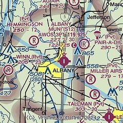
| Sectional chart |
|---|
|
| Airport distance calculator |
|---|
|
|
| Sunrise and sunset |
|---|
|
Times for 10-May-2026
| | Local
(UTC-7) | | Zulu
(UTC) |
|---|
| Morning civil twilight | | 05:18 | | 12:18 |
| Sunrise | | 05:51 | | 12:51 |
| Sunset | | 20:26 | | 03:26 |
| Evening civil twilight | | 21:00 | | 04:00 |
|
| Current date and time |
|---|
| Zulu (UTC) | 10-May-2026 22:26:40 |
|---|
| Local (UTC-7) | 10-May-2026 15:26:40 |
|---|
|
| METAR |
|---|
KCVO
12nm SW | 102156Z AUTO 04011G18KT 10SM SCT060 22/12 A3011 RMK AO2 SLP200 T02220117
|
KSLE
16nm N | 102156Z VRB04KT 10SM BKN038 21/10 A3010 RMK AO2 SLP193 T02060100
|
|
| TAF |
|---|
KSLE
16nm N | 101734Z 1018/1118 VRB04KT P6SM BKN025 FM102000 32010KT P6SM SCT025 BKN150 FM110500 34003KT P6SM SCT150 FM111500 36008KT P6SM SCT150
|
|
| NOTAMs |
|---|
NOTAMs are issued by the DoD/FAA and will open in a separate window not controlled by AirNav.
|
|

