FAA INFORMATION EFFECTIVE 16 APRIL 2026
Location
| FAA Identifier: | EMP |
| Lat/Long: | 38-19-50.0280N 096-11-23.7550W
38-19.833800N 096-11.395917W
38.3305633,-96.1899319
(estimated) |
| Elevation: | 1207.7 ft. / 368.1 m (surveyed) |
| Variation: | 05E (2000) |
| From city: | 4 miles S of EMPORIA, KS |
| Time zone: | UTC -5 (UTC -6 during Standard Time) |
| Zip code: | 66801 |
Airport Operations
| Airport use: | Open to the public |
| Activation date: | 12/1944 |
| Control tower: | no |
| ARTCC: | KANSAS CITY CENTER |
| FSS: | WICHITA FLIGHT SERVICE STATION |
| NOTAMs facility: | EMP (NOTAM-D service available) |
| Attendance: | 0730-1730 |
| Wind indicator: | lighted |
| Segmented circle: | yes |
| Lights: | ACTVT PAPI & REIL RY 01/19 - CTAF. ACTVT MIRL RY 01/19 AFT 1800 - CTAF. |
| Beacon: | white-green (lighted land airport)
SS-SR. |
Airport Communications
| CTAF/UNICOM: | 122.8 |
| WX ASOS: | 126.125 (620-343-3733) |
- APCH/DEP CTL SVC PRVDD BY KANSAS CITY ARTCC (ZKC) ON FREQS 127.725/270.25 (EMPORIA RCAG).
Nearby radio navigation aids
| VOR radial/distance | | VOR name | | Freq | | Var |
|---|
| EMPr306/3.4 | | EMPORIA VORTAC | | 112.80 | | 08E |
| NDB name | | Hdg/Dist | | Freq | | Var | | ID |
|---|
| HERINGTON | | 121/36.4 | | 407 | | 06E | | HRU | .... .-. ..- |
Airport Services
| Fuel available: | 100LL JET-A1+ MOGAS
100LL:100 LL & MOGAS 24 HR SELF-SERVE..
A1+:JET A FULL SERVE. AFTR HRS ON REQ. |
| Parking: | hangars and tiedowns |
| Airframe service: | NONE |
| Powerplant service: | NONE |
| Bottled oxygen: | NONE |
| Bulk oxygen: | NONE |
Runway Information
Runway 1/19
| Dimensions: | 5005 x 100 ft. / 1526 x 30 m |
| Surface: | asphalt/concrete, in good condition |
| Weight bearing capacity: | | PCN 11 /F/C/X/U | | Single wheel: | 30.0 | | Double wheel: | 45.0 |
|
| Runway edge lights: | medium intensity |
| Operational restrictions: | NO LINE OF SIGHT BETWEEN RWY ENDS. |
| RUNWAY 1 | | RUNWAY 19 |
| Latitude: | 38-19.523807N | | 38-20.330012N |
| Longitude: | 096-11.580277W | | 096-11.361193W |
| Elevation: | 1204.4 ft. | | 1192.9 ft. |
| Traffic pattern: | left | | left |
| Runway heading: | 007 magnetic, 012 true | | 187 magnetic, 192 true |
| Markings: | nonprecision, in good condition | | nonprecision, in good condition |
| Visual slope indicator: | 4-light PAPI on left (3.00 degrees glide path) | | 4-light PAPI on left (3.00 degrees glide path) |
| Runway end identifier lights: | yes | | yes |
| Touchdown point: | yes, no lights | | yes, no lights |
| Obstructions: | none | | 35 ft. trees, 856 ft. from runway, 250 ft. right of centerline, 18:1 slope to clear |
Runway 6/24
| Dimensions: | 3881 x 300 ft. / 1183 x 91 m |
| Surface: | turf, in fair condition
SOFT WHEN WET. |
| RUNWAY 6 | | RUNWAY 24 |
| Latitude: | 38-19.576790N | | 38-19.850658N |
| Longitude: | 096-11.666093W | | 096-10.932698W |
| Elevation: | 1204.5 ft. | | 1201.4 ft. |
| Traffic pattern: | left | | left |
| Runway heading: | 060 magnetic, 065 true | | 240 magnetic, 245 true |
| Touchdown point: | yes, no lights | | yes, no lights |
Airport Ownership and Management from official FAA records
| Ownership: | Publicly-owned |
| Owner: | CITY OF EMPORIA
104 E 5TH STREET, P O BOX 928
EMPORIA, KS 66801
Phone 620-342-5105
CITY MGR, TREY COCKING. |
| Manager: | KEN ADAMS
1005 COUNTY RD 120
EMPORIA, KS 66801
Phone 620-343-5600 |
Additional Remarks
| - | ULTRALIGHT ACTVTY ON & INVOF ARPT. |
| - | FOR CD IF UNA TO CTC ON FSS FREQ, CTC KANSAS CITY ARTCC AT 913-254-8508. |
| - | RCO AVBL 127.725 KANSAS CITY CTR. |
| - | RWY 6/24 ENDS AND EDGES MARKED WITH ORANGE AND WHITE PANELS. |
Instrument Procedures
NOTE: All procedures below are presented as PDF files. If you need a reader for these files, you should download the free Adobe Reader.NOT FOR NAVIGATION. Please procure official charts for flight.
FAA instrument procedures published for use from 16 April 2026 at 0901Z to 14 May 2026 at 0900Z.
IAPs - Instrument Approach Procedures |
|---|
| RNAV (GPS) RWY 01 | |
download (212KB) |
| RNAV (GPS) RWY 19 | |
download (200KB) |
| VOR-A | |
download (177KB) |
| NOTE: Special Take-Off Minimums/Departure Procedures apply | |
download (375KB) |
Other nearby airports with instrument procedures:
KUKL - Coffey County Airport (22 nm E)
13K - Lt. William M. Milliken Airport (29 nm S)
KHRU - Herington Regional Airport (36 nm NW)
KFOE - Topeka Regional Airport (45 nm NE)
KEQA - El Dorado/Capt Jack Thomas Memorial Airport (45 nm SW)
|
|

Road maps at:
MapQuest
Bing
Google
| Aerial photo |
|---|
WARNING: Photo may not be current or correct

Do you have a better or more recent aerial photo of Emporia Municipal Airport that you would like to share? If so, please send us your photo.
|
| Sectional chart |
|---|
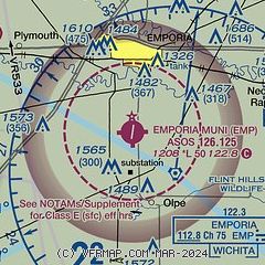
|
| Airport distance calculator |
|---|
|
|
| Sunrise and sunset |
|---|
|
Times for 12-May-2026
| | Local
(UTC-5) | | Zulu
(UTC) |
|---|
| Morning civil twilight | | 05:48 | | 10:48 |
| Sunrise | | 06:17 | | 11:17 |
| Sunset | | 20:25 | | 01:25 |
| Evening civil twilight | | 20:54 | | 01:54 |
|
| Current date and time |
|---|
| Zulu (UTC) | 12-May-2026 06:12:53 |
|---|
| Local (UTC-5) | 12-May-2026 01:12:53 |
|---|
|
| METAR |
|---|
| KEMP | 120553Z AUTO 20010KT 10SM CLR 13/07 A3012 RMK AO2 SLP195 T01330072 10244 20133 402610072 58003
|
|
| TAF |
|---|
KFOE
44nm NE | 120534Z 1206/1306 19011KT P6SM FEW200 FM121500 23014G24KT P6SM SCT060 FM122200 29011KT P6SM SCT060 FM130000 34008KT P6SM FEW250
|
|
| NOTAMs |
|---|
NOTAMs are issued by the DoD/FAA and will open in a separate window not controlled by AirNav.
|
|

