FAA INFORMATION EFFECTIVE 30 OCTOBER 2025
Location
| FAA Identifier: | FCH |
| Lat/Long: | 36-43-55.6470N 119-49-13.1970W
36-43.927450N 119-49.219950W
36.7321242,-119.8203325
(estimated) |
| Elevation: | 279.8 ft. / 85.3 m (surveyed) |
| Variation: | 15E (1985) |
| From city: | 2 miles W of FRESNO, CA |
| Time zone: | UTC -8 (UTC -7 during Daylight Saving Time) |
| Zip code: | 93706 |
Airport Operations
| Airport use: | Open to the public |
| Activation date: | 04/1940 |
| Control tower: | no |
| ARTCC: | OAKLAND CENTER |
| FSS: | RANCHO MURIETA FLIGHT SERVICE STATION |
| NOTAMs facility: | FCH (NOTAM-D service available) |
| Attendance: | 0800-1700 |
| Pattern altitude: | VFR HEL 520 FT AGL, VFR 1020 FT AGL. |
| Wind indicator: | yes |
| Segmented circle: | yes |
| Lights: | ACTVT REIL RWY 12 & 30; PAPI RWY 12 & 30; MIRL RWY 12/30 AND TWY LGTS - CTAF BTN SS-SR. |
| Beacon: | white-green (lighted land airport)
Operates sunset to sunrise. |
Airport Communications
| CTAF/UNICOM: | 123.0 |
| WX AWOS-3: | 135.225 (559-488-1040) |
| FRESNO APPROACH: | 119.0 119.6 |
| FRESNO DEPARTURE: | 119.0 |
| CLEARANCE DELIVERY: | 119.0 |
| WX ASOS at FAT (6 nm NE): | PHONE 559-203-3918 |
| WX AWOS-3PT at O32 (18 nm E): | 120.175 (559-637-9453) |
Nearby radio navigation aids
| VOR radial/distance | | VOR name | | Freq | | Var |
|---|
| FRAr189/24.8 | | FRIANT VORTAC | | 115.60 | | 17E |
Airport Services
| Fuel available: | 100LL JET-A
100LL:100LL FUEL AVBL 24/7 |
| Parking: | hangars and tiedowns |
| Airframe service: | MINOR |
| Powerplant service: | MINOR |
| Bulk oxygen: | NONE |
Runway Information
Runway 12/30
| Dimensions: | 3627 x 75 ft. / 1106 x 23 m |
| Surface: | asphalt, in good condition |
| Weight bearing capacity: | |
| Runway edge lights: | medium intensity |
| RUNWAY 12 | | RUNWAY 30 |
| Latitude: | 36-44.101708N | | 36-43.753168N |
| Longitude: | 119-49.521612W | | 119-48.918327W |
| Elevation: | 278.1 ft. | | 279.2 ft. |
| Traffic pattern: | right | | left |
| Runway heading: | 110 magnetic, 125 true | | 290 magnetic, 305 true |
| Displaced threshold: | 415 ft. | | 538 ft. |
| Markings: | nonprecision, in good condition | | nonprecision, in good condition |
| Visual slope indicator: | 2-light PAPI on left (3.00 degrees glide path) | | 4-light PAPI on right (3.00 degrees glide path) |
| Runway end identifier lights: | yes | | yes |
| Touchdown point: | yes, no lights | | yes, no lights |
| Obstructions: | 15 ft. road, 450 ft. from runway, 150 ft. left of centerline, 16:1 slope to clear
APCH RATIO 46:1 FM DSPLCD THR. | | 15 ft. road, 360 ft. from runway, 140 ft. left of centerline, 10:1 slope to clear
APCH RATIO 43:1 FM DSPLCD THR. |
Airport Ownership and Management from official FAA records
| Ownership: | Publicly-owned |
| Owner: | CITY OF FRESNO
4995 E. CLINTON WAY
FRESNO, CA 93727-1525
Phone 559-621-4500 |
| Manager: | FRANCISCO PARTIDA
510 WEST KEARNEY BLVD
FRESNO, CA 93706
Phone 559-621-4531 |
Additional Remarks
| - | NMRS BIRDS IN VCNTY OF ARPT. |
| - | PRACTICE LDGS & LOW APCHS & TGL OR STOP-AND-GO OPNS AUTH ONLY BTN 0700-2200. |
| - | RY 30 CALM WIND RY WHEN WIND REPORTED BY AWOS LESS THAN 5 KNOTS. |
| - | RY 12 PRACTICE LDGS & LOW APCHS & TGL OR STOP-AND-GO OPNS NOT PERMITTED DUE TO NOISE SENSITIVE RESIDENTIAL AREAS SE OF ARPT. |
| - | AFT TKOF CLIMB ON RY HEADING UNTIL PASSING 800 FT MSL; FOR SAFETY & NOISE ABATEMENT INITIAL CLIMBOUT AT BEST RATE-OF-CLIMB RECOMMENDED. |
| - | FOR CD CTC FRESNO APCH AT 559-454-9828. |
Instrument Procedures
NOTE: All procedures below are presented as PDF files. If you need a reader for these files, you should download the free Adobe Reader.NOT FOR NAVIGATION. Please procure official charts for flight.
FAA instrument procedures published for use from 30 October 2025 at 0901Z to 27 November 2025 at 0900Z.
IAPs - Instrument Approach Procedures |
|---|
| RNAV (GPS) RWY 12 | |
download (209KB) |
| RNAV (GPS) RWY 30 | |
download (176KB) |
| NOTE: Special Alternate Minimums apply | |
download (132KB) |
| NOTE: Special Take-Off Minimums/Departure Procedures apply | |
download (347KB) |
Other nearby airports with instrument procedures:
KFAT - Fresno Yosemite International Airport (6 nm NE)
O32 - Reedley Municipal Airport (18 nm E)
KMAE - Madera Municipal Airport (21 nm NW)
KNLC - Lemoore Naval Air Station (Reeves Field) (25 nm S)
KHJO - Hanford Municipal Airport (27 nm S)
|
|

Road maps at:
MapQuest
Bing
Google
| Aerial photo |
|---|
WARNING: Photo may not be current or correct
 Photo by Bjorn Beijens
Photo taken 01-May-2006
Photo by Bjorn Beijens
Photo taken 01-May-2006
Do you have a better or more recent aerial photo of Fresno Chandler Executive Airport that you would like to share? If so, please send us your photo.
|
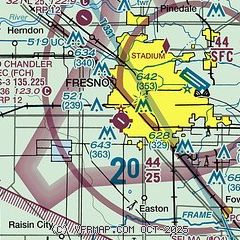
| Sectional chart |
|---|
|
CAUTION: Diagram may not be current
 Download PDF
of official airport diagram from the FAA
| Airport distance calculator |
|---|
|
|
| Sunrise and sunset |
|---|
|
Times for 02-Nov-2025
| | Local
(UTC-8) | | Zulu
(UTC) |
|---|
| Morning civil twilight | | 05:58 | | 13:58 |
| Sunrise | | 06:25 | | 14:25 |
| Sunset | | 17:01 | | 01:01 |
| Evening civil twilight | | 17:28 | | 01:28 |
|
| Current date and time |
|---|
| Zulu (UTC) | 03-Nov-2025 00:04:36 |
|---|
| Local (UTC-8) | 02-Nov-2025 16:04:36 |
|---|
|
| METAR |
|---|
| KFCH | 022335Z AUTO 00000KT 10SM CLR 25/12 A3003 RMK A01
|
KFAT
6nm NE | 022353Z 00000KT 10SM SCT160 BKN200 BKN250 26/12 A3002 RMK AO2 SLP163 T02560122 10256 20194 56011 $
|
KO32
18nm E | 022355Z AUTO 00000KT 10SM CLR 24/14 A2999 RMK AO2 T02450141
|
|
| TAF |
|---|
KFAT
6nm NE | 022027Z 0220/0318 VRB05KT P6SM SCT200 FM031200 VRB02KT 4SM BR SKC
|
|
| NOTAMs |
|---|
NOTAMs are issued by the DoD/FAA and will open in a separate window not controlled by AirNav.
|
|


