FAA INFORMATION EFFECTIVE 16 APRIL 2026
Location
| FAA Identifier: | MHV |
| Lat/Long: | 35-03-32.2000N 118-09-02.2000W
35-03.536667N 118-09.036667W
35.0589444,-118.1506111
(estimated) |
| Elevation: | 2801.3 ft. / 853.8 m (surveyed) |
| Variation: | 14E (2000) |
| From city: | 1 mile E of MOJAVE, CA |
| Time zone: | UTC -7 (UTC -8 during Standard Time) |
| Zip code: | 93501 |
Airport Operations
| Airport use: | Open to the public |
| Activation date: | 04/1940 |
| Control tower: | yes |
| ARTCC: | LOS ANGELES CENTER |
| FSS: | RIVERSIDE FLIGHT SERVICE STATION |
| NOTAMs facility: | MHV (NOTAM-D service available) |
| Attendance: | CONTINUOUS |
| Pattern altitude: | CAT C/D & ALL TBJT ACFT TPA 4301 FT MSL (1500 FT AGL); CAT A/B ACFT TPA 3801 FT MSL (1000 FT AGL); HEL TPA 3301 FT MSL (500 FT AGL) AND USE SOUTH ENTRY AND DEP. |
| Wind indicator: | lighted |
| Segmented circle: | yes |
| Lights: | ACTVT REIL RWYS 12 & 30; MIRL RWYS 08/26 & 04/22; HIRL RWY 12/30 - CTAF. |
| Beacon: | white-green (lighted land airport)
Operates sunset to sunrise. |
Airport Communications
| CTAF: | 127.6 |
| WX AWOS-3PT: | 132.225 (661-824-5218) |
| MOJAVE GROUND: | 123.9 [0700-1700 MON-FRI] |
| MOJAVE TOWER: | 127.6 288.35 [0700-1700 MON-FRI] |
| JOSHUA APPROACH: | 133.65 |
| JOSHUA DEPARTURE: | 133.65 |
| WX AWOS-1 at L71 (9 nm NE): | 120.875 (760-373-7670) |
| WX AWOS-3P at TSP (15 nm W): | 120.025 (661-823-0473) |
| WX ASOS at WJF (19 nm S): | PHONE 661-743-6026 |
Nearby radio navigation aids
| VOR radial/distance | | VOR name | | Freq | | Var |
|---|
| EDWr271/21.0 | | EDWARDS VORTAC | | 116.40 | | 12E |
| PMDr336/26.0 | | PALMDALE VORTAC | | 115.55 | | 15E |
| LHSr028/30.8 | | LAKE HUGHES VORTAC | | 114.35 | | 15E |
| GMNr050/38.2 | | GORMAN VORTAC | | 116.10 | | 16E |
Airport Services
| Fuel available: | 100LL JET-A JET-A+
100LL:FUEL AVBL 0700-1700, MON-SAT. OTR TIMES CTC ARPT OPNS ON CTAF OR CALL 661-824-2434; FEE CHARGED.
A+:FUEL AVBL 0700-1700, MON-SAT. OTR TIMES CTC ARPT OPNS ON CTAF OR CALL 661-824-2434; FEE CHARGED. |
| Parking: | tiedowns |
| Airframe service: | MAJOR |
| Powerplant service: | MAJOR |
| Bottled oxygen: | NONE |
| Bulk oxygen: | NONE |
Runway Information
Runway 12/30
| Dimensions: | 12503 x 200 ft. / 3811 x 61 m |
| Surface: | asphalt, in excellent condition |
| Weight bearing capacity: | | Single wheel: | 120.0 | | Double wheel: | 150.0 | | Double tandem: | 450.0 |
|
| Runway edge lights: | high intensity |
| RUNWAY 12 | | RUNWAY 30 |
| Latitude: | 35-04.148750N | | 35-02.687950N |
| Longitude: | 118-09.625633W | | 118-07.858097W |
| Elevation: | 2801.3 ft. | | 2680.2 ft. |
| Traffic pattern: | left | | right |
| Runway heading: | 121 magnetic, 135 true | | 301 magnetic, 315 true |
| Displaced threshold: | 600 ft. | | 900 ft. |
| Markings: | nonprecision, in fair condition | | nonprecision, in fair condition |
| Visual slope indicator: | 4-light PAPI on left (3.50 degrees glide path)
PAPI UNUSBL BYD 2.5 NM. | | 4-light PAPI on left (3.00 degrees glide path) |
| Runway end identifier lights: | yes | | yes |
| Touchdown point: | yes, no lights | | yes, no lights |
| Obstructions: | 375 ft. other, 14400 ft. from runway, 250 ft. left of centerline, 37:1 slope to clear
APPROACH SLOPE 40:1 TO THE DSPLCD THR. | | none |
Runway 8/26
| Dimensions: | 7049 x 100 ft. / 2149 x 30 m
300 FT PAVED OVERRUN EAST END OF RY; 300 FT PAVED OVERRUN WEST END OF RY. |
| Surface: | asphalt, in good condition |
| Weight bearing capacity: | | Single wheel: | 40.0 | | Double wheel: | 60.0 | | Double tandem: | 88.0 |
|
| Runway edge lights: | medium intensity |
| RUNWAY 8 | | RUNWAY 26 |
| Latitude: | 35-03.553058N | | 35-03.549992N |
| Longitude: | 118-09.964400W | | 118-08.551457W |
| Elevation: | 2780.4 ft. | | 2734.9 ft. |
| Traffic pattern: | left | | right |
| Runway heading: | 076 magnetic, 090 true | | 256 magnetic, 270 true |
| Markings: | nonprecision, in good condition | | nonprecision, in good condition |
| Visual slope indicator: | 2-light PAPI on left (4.00 degrees glide path) | | 2-light PAPI on left (3.00 degrees glide path) |
| Runway end identifier lights: | no | | no |
| Touchdown point: | yes, no lights | | yes, no lights |
Runway 4/22
| Dimensions: | 4747 x 60 ft. / 1447 x 18 m |
| Surface: | asphalt, in excellent condition |
| Weight bearing capacity: | | Single wheel: | 40.0 | | Double wheel: | 60.0 | | Double tandem: | 60.0 |
|
| Runway edge lights: | medium intensity |
| RUNWAY 4 | | RUNWAY 22 |
| Latitude: | 35-03.584037N | | 35-04.068087N |
| Longitude: | 118-09.857918W | | 118-09.110313W |
| Elevation: | 2779.9 ft. | | 2779.1 ft. |
| Traffic pattern: | left | | right |
| Runway heading: | 038 magnetic, 052 true | | 218 magnetic, 232 true |
| Markings: | nonprecision, in good condition | | nonprecision, in good condition |
| Visual slope indicator: | 2-light PAPI on left (4.00 degrees glide path) | | 2-light PAPI on left (3.00 degrees glide path) |
| Runway end identifier lights: | no | | no |
| Touchdown point: | yes, no lights | | yes, no lights |
| Obstructions: | 44 ft. pole, 2200 ft. from runway, 45:1 slope to clear | | none |
Airport Ownership and Management from official FAA records
| Ownership: | Publicly-owned |
| Owner: | MOJAVE AIR AND SPACE PORT
1434 FLIGHTLINE
MOJAVE, CA 93501
Phone 661-824-2433 |
| Manager: | DAVID SMITH
1434 FLIGHTLINE
MOJAVE, CA 93501
Phone 661-824-2433 |
Additional Remarks
| - | BE ALERT TO HIGH SPEED ACTIVITY INVOF ARPT. |
| - | DUE TO RAPIDLY RISING TERRAIN AND WIND TURBINES W - NW OF ARPT, CAT C/D & ALL TURBOJET ACFT LDG RWY 8 MUST REMAIN AT OR ABOVE 4301 FT MSL UNTIL COMMENCING BASE LEG TURN AND AT OR ABOVE 3800 FT MSL UNTIL ESTABLISHED ON A 2.25 NM FINAL. |
| - | TWY F IS CLSD WEST OF TWY A. |
Instrument Procedures
NOTE: All procedures below are presented as PDF files. If you need a reader for these files, you should download the free Adobe Reader.NOT FOR NAVIGATION. Please procure official charts for flight.
FAA instrument procedures published for use from 16 April 2026 at 0901Z to 14 May 2026 at 0900Z.
IAPs - Instrument Approach Procedures |
|---|
| RNAV (GPS) RWY 04 | |
download (354KB) |
| RNAV (GPS) RWY 22 | |
download (471KB) |
| RNAV (GPS) RWY 30 | |
download (336KB) |
| NOTE: Special Alternate Minimums apply | |
download (140KB) |
Departure Procedures |
|---|
| GLAZY ONE (RNAV) | |
download (147KB) |
| JERID FIVE (RNAV) | |
download (164KB) |
| NOTE: Special Take-Off Minimums/Departure Procedures apply | |
download (355KB) |
Other nearby airports with instrument procedures:
L71 - California City Municipal Airport (9 nm NE)
KEDW - Edwards Air Force Base (16 nm SE)
KWJF - General Wm J Fox Airfield (19 nm S)
KPMD - Palmdale USAF Plant 42 Airport (26 nm S)
KIYK - Inyokern Airport (39 nm NE)
|
|

Road maps at:
MapQuest
Bing
Google
| Aerial photo |
|---|
WARNING: Photo may not be current or correct
 Photo courtesy of focalflight.com
Photo taken 04-Jun-2017
looking southeast.
Photo courtesy of focalflight.com
Photo taken 04-Jun-2017
looking southeast.
Do you have a better or more recent aerial photo of Mojave Air & Space Port/Rutan Field that you would like to share? If so, please send us your photo.
|
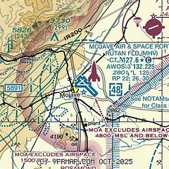
| Sectional chart |
|---|
|
 Download PDF
of official airport diagram from the FAA
| Airport distance calculator |
|---|
|
|
| Sunrise and sunset |
|---|
|
Times for 29-Apr-2026
| | Local
(UTC-7) | | Zulu
(UTC) |
|---|
| Morning civil twilight | | 05:38 | | 12:38 |
| Sunrise | | 06:05 | | 13:05 |
| Sunset | | 19:35 | | 02:35 |
| Evening civil twilight | | 20:02 | | 03:02 |
|
| Current date and time |
|---|
| Zulu (UTC) | 29-Apr-2026 14:46:15 |
|---|
| Local (UTC-7) | 29-Apr-2026 07:46:15 |
|---|
|
| METAR |
|---|
| KMHV | 291435Z AUTO 00000KT 10SM CLR 14/05 A3008 RMK AO2 T01410046 $
|
KTSP
15nm W | 291435Z AUTO 00000KT 9SM CLR 07/06 A3014 RMK AO2
|
KEDW
17nm SE | 291355Z 22005KT 40SM CLR 08/02 A3005 RMK AO2A SLP167 T00790015
|
|
| TAF |
|---|
KEDW
17nm SE | 291200Z 2912/3018 VRB06KT 9999 SKC 510006 QNH2992INS BECMG 3000/3001 21010G18KT 9999 SKC 510006 QNH2992INS BECMG 3006/3007 VRB05KT 9999 SKC QNH2991INS TX26/2922Z TN06/2913Z
|
KWJF
21nm S | 291125Z 2912/3012 VRB05KT P6SM SKC FM292100 26008KT P6SM SKC FM300000 26015KT P6SM SKC FM300600 26010KT P6SM SKC FM301000 26005KT P6SM SKC
|
|
| NOTAMs |
|---|
NOTAMs are issued by the DoD/FAA and will open in a separate window not controlled by AirNav.
|
|


