FAA INFORMATION EFFECTIVE 22 JANUARY 2026
Location
| FAA Identifier: | PTV |
| Lat/Long: | 36-01-46.5000N 119-03-45.8000W
36-01.775000N 119-03.763333W
36.0295833,-119.0627222
(estimated) |
| Elevation: | 443.2 ft. / 135.1 m (surveyed) |
| Variation: | 15E (1980) |
| From city: | 3 miles SW of PORTERVILLE, CA |
| Time zone: | UTC -8 (UTC -7 during Daylight Saving Time) |
| Zip code: | 93257 |
Airport Operations
| Airport use: | Open to the public |
| Activation date: | 09/1942 |
| Control tower: | no |
| ARTCC: | LOS ANGELES CENTER |
| FSS: | RANCHO MURIETA FLIGHT SERVICE STATION |
| NOTAMs facility: | PTV (NOTAM-D service available) |
| Attendance: | MAY-OCT 0700-1900, NOV-APR 0800-1700
ARPT ATTENDANT 559-782-7540. |
| Wind indicator: | lighted |
| Segmented circle: | yes |
| Lights: | HIRL RY 12/30 PRESET LOW INTST DUSK-2300; AFTER 2300 ACTVT - CTAF. ACTVT VASI RY 12 - CTAF, VASI RY 30 OPER CONTINUOUSLY. |
| Beacon: | white-green (lighted land airport)
Operates sunset to sunrise. |
Airport Communications
| CTAF/UNICOM: | 122.8 |
| WX AWOS-3PT: | 134.625 (559-784-3874) |
| BAKERSFIELD APPROACH: | 119.075 [1500-0700Z++, OT CTC LOS ANGELES CENTER] |
| BAKERSFIELD DEPARTURE: | 119.075 [1500-0700Z++, OT CTC LOS ANGELES CENTER] |
| WX AWOS-3PT at TLR (15 nm NW): | 120.0 (559-686-2613) |
| WX AWOS-3P at DLO (19 nm SW): | 119.55 (661-721-2668) |
- APCH/DEP CTL SVC PRVDD BY LOS ANGELES ARTCC (ZLA) ON FREQS 127.1/317.7 (BAKERSFIELD RCAG) WHEN BAKERSFIELD APCH CTL (BFL) CLSD.
- COMMUNICATIONS PRVDD BY RANCHO MURIETA RADIO ON FREQS 122.1R/109.2T (TULE RCO).
Nearby radio navigation aids
| VOR radial/distance | | VOR name | | Freq | | Var |
|---|
| TTEr328/7.3 | | TULE VOR/DME | | 116.25 | | 16E |
| EHFr349/32.7 | | SHAFTER VORTAC | | 115.40 | | 14E |
| NDB name | | Hdg/Dist | | Freq | | Var | | ID |
|---|
| SALYER FARMS | | 080/22.8 | | 205 | | 16E | | COR | -.-. --- .-. |
Airport Services
| Fuel available: | 100LL JET-A
100LL:SELF SERVICE FUEL AVBL 24 HRS WITH CREDIT CARD. |
| Parking: | tiedowns |
| Airframe service: | MAJOR |
| Powerplant service: | MAJOR |
| Bottled oxygen: | NONE |
Runway Information
Runway 12/30
| Dimensions: | 5960 x 150 ft. / 1817 x 46 m |
| Surface: | asphalt/grooved, in good condition |
| Weight bearing capacity: | | Single wheel: | 30.0 | | Double wheel: | 70.0 | | Double tandem: | 110.0 |
|
| Runway edge lights: | high intensity |
| RUNWAY 12 | | RUNWAY 30 |
| Latitude: | 36-02.124392N | | 36-01.426462N |
| Longitude: | 119-04.188060W | | 119-03.337013W |
| Elevation: | 431.2 ft. | | 443.1 ft. |
| Traffic pattern: | left | | left |
| Runway heading: | 120 magnetic, 135 true | | 300 magnetic, 315 true |
| Markings: | nonprecision, in fair condition | | nonprecision, in fair condition |
| Visual slope indicator: | 4-box VASI on right (3.00 degrees glide path) | | 4-box VASI on right (3.00 degrees glide path) |
| Runway end identifier lights: | no | | yes |
| Touchdown point: | yes, no lights | | yes, no lights |
| Obstructions: | 15 ft. road, 480 ft. from runway, 292 ft. left of centerline, 18:1 slope to clear | | 15 ft. road, 520 ft. from runway, 298 ft. left of centerline, 21:1 slope to clear |
Airport Ownership and Management from official FAA records
| Ownership: | Publicly-owned |
| Owner: | CITY OF PORTERVILLE
291 N. MAIN STREET
PORTERVILLE, CA 93257-7466
Phone 559-782-7540 |
| Manager: | RICHARD TREE
1893 SOUTH NEWCOMB ROAD
PORTERVILLE, CA 93257-7466
Phone 559-483-0904
EMERGENCY CONTACT PORTERVILLE PD 559-782-7400 |
Instrument Procedures
NOTE: All procedures below are presented as PDF files. If you need a reader for these files, you should download the free Adobe Reader.NOT FOR NAVIGATION. Please procure official charts for flight.
FAA instrument procedures published for use from 22 January 2026 at 0901Z to 19 February 2026 at 0900z.
IAPs - Instrument Approach Procedures |
|---|
| GPS RWY 12 | |
download (236KB) |
| GPS RWY 30 | |
download (347KB) |
| VOR-A | |
download (305KB) |
| NOTE: Special Alternate Minimums apply | |
download (139KB) |
| NOTE: Special Take-Off Minimums/Departure Procedures apply | |
download (246KB) |
Other nearby airports with instrument procedures:
KTLR - Mefford Field Airport (15 nm NW)
KDLO - Delano Municipal Airport (19 nm SW)
KVIS - Visalia Municipal Airport (24 nm NW)
KMIT - Shafter Airport-Minter Field (32 nm S)
KHJO - Hanford Municipal Airport (32 nm NW)
|
|

Road maps at:
MapQuest
Bing
Google
| Aerial photo |
|---|
WARNING: Photo may not be current or correct
 Photo courtesy of www.focalflight.com
Photo taken 04-Oct-2017
looking west.
Photo courtesy of www.focalflight.com
Photo taken 04-Oct-2017
looking west.
Do you have a better or more recent aerial photo of Porterville Municipal Airport that you would like to share? If so, please send us your photo.
|
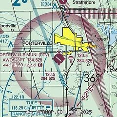
| Sectional chart |
|---|
|
| Airport distance calculator |
|---|
|
|
| Sunrise and sunset |
|---|
|
Times for 09-Feb-2026
| | Local
(UTC-8) | | Zulu
(UTC) |
|---|
| Morning civil twilight | | 06:24 | | 14:24 |
| Sunrise | | 06:51 | | 14:51 |
| Sunset | | 17:30 | | 01:30 |
| Evening civil twilight | | 17:57 | | 01:57 |
|
| Current date and time |
|---|
| Zulu (UTC) | 10-Feb-2026 07:23:08 |
|---|
| Local (UTC-8) | 09-Feb-2026 23:23:08 |
|---|
|
| METAR |
|---|
| KPTV | 100656Z AUTO 00000KT 5SM BR OVC013 11/10 A2998 RMK AO2 SLP153 T01060100 $
|
KDLO
19nm SW | 100655Z AUTO 00000KT 5SM BR CLR 09/08 A2998 RMK AO2 T00880081
|
|
| TAF |
|---|
KVIS
24nm NW | 100520Z 1006/1106 04006KT 5SM BR SCT013 FM101200 VRB03KT 1SM BR OVC250 TEMPO 1012/1016 1/4SM FG OVC003 FM102000 17006KT 4SM BR OVC007 FM102200 17004KT P6SM OVC050 FM110500 14014KT 4SM BR OVC050
|
|
| NOTAMs |
|---|
NOTAMs are issued by the DoD/FAA and will open in a separate window not controlled by AirNav.
|
|

