FAA INFORMATION EFFECTIVE 16 APRIL 2026
Location
| FAA Identifier: | ROW |
| Lat/Long: | 33-17-59.5590N 104-31-45.8510W
33-17.992650N 104-31.764183W
33.2998775,-104.5294031
(estimated) |
| Elevation: | 3671 ft. / 1118.9 m (surveyed) |
| Variation: | 10E (1995) |
| From city: | 3 miles S of ROSWELL, NM |
| Time zone: | UTC -6 (UTC -7 during Standard Time) |
| Zip code: | 88203 |
Airport Operations
| Airport use: | Open to the public |
| Activation date: | 10/1967 |
| Control tower: | yes |
| ARTCC: | ALBUQUERQUE CENTER |
| FSS: | ALBUQUERQUE FLIGHT SERVICE STATION |
| NOTAMs facility: | ROW (NOTAM-D service available) |
| Attendance: | 0600-2100
AFT HR - 575-347-2054 OR 575-626-3697. |
| Wind indicator: | lighted |
| Segmented circle: | yes |
| Lights: | ACTVT MALSR RWY 21; MIRL RWY 17/35 - CTAF. VASI RWY 03; PAPI RWY 17 & 35 - ON CONSLY. WHEN ATCT CLSD MIRL RWY 03/21 ON MED INTST. |
| Beacon: | white-green (lighted land airport)
Operates sunset to sunrise. |
| Fire and rescue: | ARFF index A |
| International operations: | customs landing rights airport |
Airport Communications
| CTAF: | 118.5 |
| UNICOM: | 122.95 |
| ATIS: | 128.45 306.2 |
| WX ASOS: | 128.45 (575-286-1096) |
| ROSWELL GROUND: | 121.9 348.6 [0600-2100] |
| ROSWELL TOWER: | 118.5 233.7 [0600-2100] |
| ROSWELL APPROACH: | 119.6 ;EAST OF V291 120.35 ;WEST OF V291 229.4 ;WEST OF V291 239.0 ;EAST OF V291 [0600-2100] |
| ROSWELL DEPARTURE: | 119.6 ;EAST OF V291 120.35 ;WEST OF V291 229.4 ;WEST OF V291 239.0 ;EAST OF V291 [0600-2100] |
| CLEARANCE DELIVERY: | 132.875 282.25 |
| EMERG: | 121.5 243.0 |
| IC: | 119.6 ;EAST OF V291 239.0 ;EAST OF V291 |
- APCH/DEP SVC PRVDD BY ALBUQUERQUE ARTCC (ZAB) ON FREQS 132.65/257.6 (ROSWELL RCAG) WHEN ROSWELL APCH CTL (ROW) CLSD.
Nearby radio navigation aids
| VOR radial/distance | | VOR name | | Freq | | Var |
|---|
| CMEr104/5.1 | | CHISUM VORTAC | | 116.10 | | 12E |
| NDB name | | Hdg/Dist | | Freq | | Var | | ID |
|---|
| TOPAN | | 218/5.9 | | 305 | | 10E | | RO | .-. --- |
Airport Services
| Fuel available: | 100LL JET-A JET-A1+
100LL:AFT HR - 575-347-2054. |
| Parking: | hangars and tiedowns |
| Airframe service: | MINOR |
| Powerplant service: | MINOR |
| Bulk oxygen: | LOW |
Runway Information
Runway 3/21
| Dimensions: | 13000 x 150 ft. / 3962 x 46 m |
| Surface: | concrete, in excellent condition |
| Weight bearing capacity: | | Single wheel: | 100.0 | | Double wheel: | 200.0 | | Double tandem: | 400.0 |
|
| Runway edge lights: | medium intensity
NSTD 75 FT FM RWY EDGE. |
| RUNWAY 3 | | RUNWAY 21 |
| Latitude: | 33-17.165648N | | 33-18.677720N |
| Longitude: | 104-32.214137W | | 104-30.405427W |
| Elevation: | 3667.2 ft. | | 3623.7 ft. |
| Traffic pattern: | right | | left |
| Runway heading: | 035 magnetic, 045 true | | 215 magnetic, 225 true |
| Declared distances: | TORA:13000 TODA:13000 ASDA:13000 LDA:13000 | | TORA:13000 TODA:13000 ASDA:13000 LDA:13000 |
| Markings: | nonprecision, in good condition | | precision, in good condition |
| Visual slope indicator: | 6-box VASI on left (3.00 degrees glide path) | | |
| Approach lights: | | | MALSR: 1,400 foot medium intensity approach lighting system with runway alignment indicator lights |
| Touchdown point: | yes, no lights | | yes, no lights |
| Instrument approach: | | | ILS/DME |
Runway 17/35
| Dimensions: | 10008 x 100 ft. / 3050 x 30 m |
| Surface: | asphalt/grooved, in good condition |
| Weight bearing capacity: | | Single wheel: | 77.0 | | Double wheel: | 104.0 | | Double tandem: | 165.0 |
|
| Runway edge lights: | medium intensity |
| RUNWAY 17 | | RUNWAY 35 |
| Latitude: | 33-18.909707N | | 33-17.259718N |
| Longitude: | 104-32.352225W | | 104-32.356340W |
| Elevation: | 3662.4 ft. | | 3671.0 ft. |
| Traffic pattern: | right | | left |
| Runway heading: | 170 magnetic, 180 true | | 350 magnetic, 000 true |
| Declared distances: | TORA:10008 TODA:10008 ASDA:10008 LDA:10008 | | TORA:10008 TODA:10008 ASDA:10008 LDA:10008 |
| Markings: | precision, in good condition | | precision, in good condition |
| Visual slope indicator: | 4-light PAPI on left (3.00 degrees glide path)
PAPI UNUSBL BYD 8 DEG RIGHT OF CNTRLN. | | 4-light PAPI on left (3.00 degrees glide path) |
| Touchdown point: | yes, no lights | | yes, no lights |
Helipad H1
| Dimensions: | 55 x 55 ft. / 17 x 17 m |
| Surface: | asphalt |
| Latitude: | 33-18.453000N | | |
| Longitude: | 104-31.820833W | | |
| Elevation: | 3660.0 ft. | | |
| Traffic pattern: | left | | left |
Helipad H2
| Dimensions: | 55 x 55 ft. / 17 x 17 m |
| Surface: | asphalt |
| Latitude: | 33-18.310500N | | |
| Longitude: | 104-31.578833W | | |
| Elevation: | 3653.0 ft. | | |
| Traffic pattern: | left | | left |
Airport Ownership and Management from official FAA records
| Ownership: | Publicly-owned |
| Owner: | CITY OF ROSWELL
425 N RICHARDSON AVE
ROSWELL, NM 88201-4730
Phone 575-624-6700
J GRIEGO. |
| Manager: | BOBBI THOMPSON
1 JERRY SMITH CIR
ROSWELL, NM 88203-8427
Phone 239-980-5114 |
Additional Remarks
| A39-03/21 | PCR VALUE: 1140/R/C/W/T |
| A39-17/35 | PCR VALUE: 150/R/C/W/T |
| - | AFT HR EXIT RAMP/FBO AREA USE LGTD PEDESTRIAN GATE - 575-347-2054. |
| - | BIRDS ON & INVOF ARPT. |
| - | LRG ACFT LONG TERM STORAGE AVBL. |
| - | FOR CD IF UNA TO CTC ON FSS FREQ, CTC ALBUQUERQUE ARTCC AT 505-856-4561. |
Instrument Procedures
NOTE: All procedures below are presented as PDF files. If you need a reader for these files, you should download the free Adobe Reader.NOT FOR NAVIGATION. Please procure official charts for flight.
FAA instrument procedures published for use from 16 April 2026 at 0901Z to 14 May 2026 at 0900Z.
IAPs - Instrument Approach Procedures |
|---|
| ILS Z OR LOC Z RWY 21 **CHANGED** | |
download (327KB) |
| RNAV (GPS) RWY 03 | |
download (264KB) |
| RNAV (GPS) RWY 17 | |
download (252KB) |
| RNAV (GPS) RWY 21 | |
download (274KB) |
| RNAV (GPS) RWY 35 | |
download (261KB) |
| LOC BC RWY 03 | |
download (251KB) |
| VOR-B | |
download (205KB) |
| Radar Approach Procedures available | |
download (145KB) |
| NOTE: Special Alternate Minimums apply | |
download (144KB) |
| NOTE: Special Take-Off Minimums/Departure Procedures apply | |
download (298KB) |
Other nearby airports with instrument procedures:
KATS - Artesia Municipal Airport (27 nm S)
KSRR - Sierra Blanca Regional Airport (51 nm W)
KCNM - Cavern City Air Terminal (59 nm S)
E06 - Lea County/Zip Franklin Memorial Airport (60 nm E)
KPRZ - Portales Municipal Airport (75 nm NE)
|
|

Road maps at:
MapQuest
Bing
Google
| Aerial photo |
|---|
WARNING: Photo may not be current or correct
 Photo by Joshua Griffin
Photo taken 21-Dec-2011
looking west.
Photo by Joshua Griffin
Photo taken 21-Dec-2011
looking west.
Do you have a better or more recent aerial photo of Roswell Air Center Airport that you would like to share? If so, please send us your photo.
|
| Sectional chart |
|---|
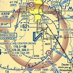
|
CAUTION: Diagram may not be current
 Download PDF
of official airport diagram from the FAA
| Airport distance calculator |
|---|
|
|
| Sunrise and sunset |
|---|
|
Times for 08-May-2026
| | Local
(UTC-6) | | Zulu
(UTC) |
|---|
| Morning civil twilight | | 05:38 | | 11:38 |
| Sunrise | | 06:05 | | 12:05 |
| Sunset | | 19:45 | | 01:45 |
| Evening civil twilight | | 20:12 | | 02:12 |
|
| Current date and time |
|---|
| Zulu (UTC) | 08-May-2026 16:45:20 |
|---|
| Local (UTC-6) | 08-May-2026 10:45:20 |
|---|
|
| METAR |
|---|
| KROW | 081551Z 16006KT 10SM CLR 19/06 A2995 RMK AO2 SLP092 T01940056 $
|
|
| TAF |
|---|
| KROW | 081120Z 0812/0912 VRB05KT P6SM SCT250 FM081600 11007KT P6SM SCT250 FM090300 19006KT P6SM SCT250
|
|
| NOTAMs |
|---|
NOTAMs are issued by the DoD/FAA and will open in a separate window not controlled by AirNav.
|
|


