FAA INFORMATION EFFECTIVE 12 JUNE 2025
Location
| FAA Identifier: | L08 |
| Lat/Long: | 33-15-32.5000N 116-19-15.5000W
33-15.541667N 116-19.258333W
33.2590278,-116.3209722
(estimated) |
| Elevation: | 522.2 ft. / 159.2 m (surveyed) |
| Variation: | 13E (2000) |
| From city: | 3 miles E of BORREGO SPRINGS, CA |
| Time zone: | UTC -7 (UTC -8 during Standard Time) |
| Zip code: | 92004 |
Airport Operations
| Airport use: | Open to the public |
| Activation date: | 04/1947 |
| Control tower: | no |
| ARTCC: | LOS ANGELES CENTER |
| FSS: | SAN DIEGO FLIGHT SERVICE STATION |
| NOTAMs facility: | SAN (NOTAM-D service available) |
| Attendance: | 0800-1600 |
| Wind indicator: | lighted |
| Segmented circle: | yes |
| Lights: | ACTVT MIRL RWY 08/26; TWY LGTS - CTAF (5 CLICKS ON). |
| Beacon: | white-green (lighted land airport)
Operates sunset to sunrise. |
Airport Communications
| CTAF/UNICOM: | 122.8 |
| WX AWOS-3P: | 126.575 (760-767-3308) |
- STAFFED 0800-1600
- APCH/DEP CTL SVC PRVDD BY LOS ANGELES ARTCC (ZLA) ON FREQS 128.6/291.7 (LAGUNA RCAG).
Nearby radio navigation aids
| VOR radial/distance | | VOR name | | Freq | | Var |
|---|
| JLIr047/15.1 | | JULIAN VORTAC | | 114.00 | | 15E |
| TRMr187/23.6 | | THERMAL VORTAC | | 116.20 | | 13E |
| PSPr159/37.1 | | PALM SPRINGS VORTAC | | 115.50 | | 13E |
Airport Services
| Fuel available: | 100LL
100LL:SELF SVC 24 HR. |
| Parking: | tiedowns |
| Airframe service: | NONE |
| Powerplant service: | NONE |
| Bottled oxygen: | NONE |
| Bulk oxygen: | NONE |
Runway Information
Runway 8/26
| Dimensions: | 5011 x 75 ft. / 1527 x 23 m
RWY 08/26 400 FT BLAST PAD BYD EACH END OF RWY AREA. |
| Surface: | asphalt, in good condition |
| Weight bearing capacity: | | Single wheel: | 30.0 | | Double wheel: | 54.0 | | Double tandem: | 90.0 |
|
| Runway edge lights: | medium intensity |
| RUNWAY 8 | | RUNWAY 26 |
| Latitude: | 33-15.533333N | | 33-15.550000N |
| Longitude: | 116-19.750000W | | 116-18.766667W |
| Elevation: | 521.4 ft. | | 522.1 ft. |
| Traffic pattern: | right | | left |
| Runway heading: | 076 magnetic, 089 true | | 256 magnetic, 269 true |
| Markings: | nonprecision, in good condition | | nonprecision, in good condition |
| Visual slope indicator: | 2-light PAPI on left (3.00 degrees glide path)
UNUSBL BYD 3.0 NM DUE TO TRRN. | | 2-light PAPI on left (3.00 degrees glide path) |
| Runway end identifier lights: | no | | no |
| Touchdown point: | yes, no lights | | yes, no lights |
Airport Ownership and Management from official FAA records
| Ownership: | Publicly-owned |
| Owner: | COUNTY OF SAN DIEGO
1960 JOE CROSSON DRIVE
EL CAJON, CA 92020-1235
Phone 619-956-4800 |
| Manager: | MEADOW CHASE
1820 PALM CANYON DR
BORREGO SPRINGS, CA 92004-1235
Phone (760) 767-7415
EMERG: 760-884-0252 |
Additional Remarks
| - | 140 FT TWR 1600 FT N OF RWY 08. |
| - | TSNT TIE-DOWN RAMP RSTRD TO ACFT WITH WINGSPAN 40 FT OR LESS. ACFT WITH GTR THAN 40 FT WINGSPAN PARK ON PORTION OF TSNT RAMP E OF A6. |
| - | MIL ROTORCRAFT OPS RSTRD TO REMAIN ON OR OVER PAVEMENT AREA, TGL RSTRD TO RWY. |
| - | HOVERS, SKID LNDGS, AUTO-ROTATIONS PROHIBITED. |
| - | FOR CD CTC LOS ANGELES ARTCC AT 661-575-2079. |
| - | PARACHUTE JUMPING. |
| - | DURING HOT WX HVY ACFT PRKG RSTRD TO CONCRETE PADS ON OUTER TSNT RAMP. |
| - | AEROBATIC BOX N SIDE OF ARPT DURING DALGT HRS FROM SFC TO 5000 FT MSL, CK NOTAMS FOR ACT. |
| - | NOISE SENSITIVE AREA W-NW. DO NOT OVERFLY ELEMENTARY SCHOOL 1 NM W OF ARPT. |
| - | BE AWARE OF FRQ CHGS IN WIND DIR, STRONG UP/DN DRAFTS AND TURB POSS DURG HIGH WIND CONDS. |
| - | ALL ACFT TFC PATS TO S. |
| - | COYOTES AND MIGRATORY BIRDS OCNLLY ON OR IN VACINITY OF ARPT. |
| - | PPR FOR ALL MIL ACFT, CTC AMGR. |
| - | ACFT MUST SELF-ANNOUNCE ON CTAF PRIOR TO LDG OR TKOF. |
Instrument Procedures
NOTE: All procedures below are presented as PDF files. If you need a reader for these files, you should download the free Adobe Reader.NOT FOR NAVIGATION. Please procure official charts for flight.
FAA instrument procedures published for use from 12 June 2025 at 0901Z to 10 July 2025 at 0900z.
IAPs - Instrument Approach Procedures |
|---|
| RNAV (GPS) RWY 26 **CHANGED** | |
download (324KB) |
| NOTE: Special Alternate Minimums apply | |
download (118KB) |
Departure Procedures |
|---|
| KUMBA ONE (RNAV) | |
download (146KB) |
|
|---|
| ZUNGU ONE (OBSTACLE) (RNAV) | |
download (181KB) |
| NOTE: Special Take-Off Minimums/Departure Procedures apply | |
download (132KB) |
Other nearby airports with instrument procedures:
KTRM - Jacqueline Cochran Regional Airport (23 nm N)
KUDD - Bermuda Dunes Airport (29 nm N)
KRNM - Ramona Airport (33 nm SW)
KPSP - Palm Springs International Airport (35 nm N)
KCLR - Cliff Hatfield Memorial Airport (41 nm E)
|
|

Road maps at:
MapQuest
Bing
Google
| Aerial photo |
|---|
WARNING: Photo may not be current or correct
 Photo courtesy of FocalFlight.com
Photo taken 23-Jan-2019
looking northeast.
Photo courtesy of FocalFlight.com
Photo taken 23-Jan-2019
looking northeast.
Do you have a better or more recent aerial photo of Borrego Valley Airport that you would like to share? If so, please send us your photo.
|
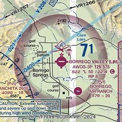
| Sectional chart |
|---|
|
| Airport distance calculator |
|---|
|
|
| Sunrise and sunset |
|---|
|
Times for 26-Jun-2025
| | Local
(UTC-7) | | Zulu
(UTC) |
|---|
| Morning civil twilight | | 05:10 | | 12:10 |
| Sunrise | | 05:39 | | 12:39 |
| Sunset | | 19:57 | | 02:57 |
| Evening civil twilight | | 20:26 | | 03:26 |
|
| Current date and time |
|---|
| Zulu (UTC) | 27-Jun-2025 00:49:48 |
|---|
| Local (UTC-7) | 26-Jun-2025 17:49:48 |
|---|
|
| METAR |
|---|
| KL08 | 270035Z AUTO 15010KT 10SM CLR 39/04 A2971 RMK AO2
|
|
| TAF |
|---|
KTRM
24nm N | 261720Z 2618/2718 14010KT P6SM SKC FM270200 34006KT P6SM SKC FM270900 VRB04KT P6SM SKC FM271700 14007KT P6SM SKC
|
|
| NOTAMs |
|---|
NOTAMs are issued by the DoD/FAA and will open in a separate window not controlled by AirNav.
|
|


