FAA INFORMATION EFFECTIVE 16 APRIL 2026
Location
| FAA Identifier: | PSP |
| Lat/Long: | 33-49-46.8110N 116-30-24.0990W
33-49.780183N 116-30.401650W
33.8296697,-116.5066942
(estimated) |
| Elevation: | 476.6 ft. / 145.3 m (surveyed) |
| Variation: | 13E (1990) |
| From city: | 2 miles E of PALM SPRINGS, CA |
| Time zone: | UTC -7 (UTC -8 during Standard Time) |
| Zip code: | 92262 |
Airport Operations
| Airport use: | Open to the public |
| Activation date: | 07/1942 |
| Control tower: | yes |
| ARTCC: | LOS ANGELES CENTER |
| FSS: | RIVERSIDE FLIGHT SERVICE STATION |
| NOTAMs facility: | PSP (NOTAM-D service available) |
| Attendance: | CONTINUOUS |
| Pattern altitude: | TPA: 1,500 FT. AGL LARGE ACFT, 1,000 FT AGL SMALL ACFT. |
| Wind indicator: | lighted |
| Segmented circle: | yes |
| Lights: | WHEN TWR CLSD ACTVT REIL RWY 13R & 31L; PAPI RWY 13R & 31L; HIRL RWY 13R/31L - CTAF. REIL RWY 13L & 31R; PAPI RWY 13L & 31R; MIRL RWY 13L/31R; TWY E NOT LGTD WHEN TWR CLSD. |
| Beacon: | white-green (lighted land airport)
Operates sunset to sunrise. |
| Fire and rescue: | ARFF index C |
| International operations: | US CUSTOMS AVBL 24 HRS; 4 HRS PRIOR NOTIFICATION REQD,
CALL (760) 318-3880, FAX 3883. |
Airport Communications
| CTAF: | 119.7 |
| UNICOM: | 122.95 |
| ATIS: | 124.65 |
| WX ASOS: | PHONE 760-322-7597 |
| PALM SPRINGS GROUND: | 121.9 [0600-2300] |
| PALM SPRINGS TOWER: | 119.7 377.05 [0600-2300] |
| SOCAL APPROACH: | 126.7 ;9000-13000 FT 135.275 ;8000 FT & BLW |
| SOCAL DEPARTURE: | 126.7 ;9000-13000 FT 135.275 ;8000 FT & BLW |
| CLEARANCE DELIVERY: | 128.35 |
| CLOWD STAR: | 126.7 |
| EMERG: | 121.5 234.0 |
| HWRRD DP: | 126.7 |
| IKONE DP: | 135.275 |
| JEEON DP: | 126.7 |
| LGANN DP: | 135.275 |
| RDBUL STAR: | 126.7 |
| SBONO STAR: | 126.7 |
| SIZLR STAR: | 134.0 |
| TRSA: | 126.7 ;9000-13000 FT 135.275 ;8000 FT & BLW |
| YUCCA DP: | 126.7 |
| WX AWOS-3 at BNG (18 nm W): | 134.625 (951-922-4674) |
Nearby radio navigation aids
| VOR radial/distance | | VOR name | | Freq | | Var |
|---|
| PSPr225/4.5 | | PALM SPRINGS VORTAC | | 115.50 | | 13E |
| TRMr292/21.1 | | THERMAL VORTAC | | 116.20 | | 13E |
| HDFr071/(34.0) | | HOMELAND VOR | | 112.05 | | 14E |
Airport Services
| Fuel available: | 100LL JET-A |
| Parking: | hangars and tiedowns |
| Airframe service: | MAJOR |
| Powerplant service: | MAJOR |
| Bottled oxygen: | LOW |
Runway Information
Runway 13R/31L
| Dimensions: | 10000 x 150 ft. / 3048 x 46 m |
| Surface: | asphalt/grooved, in good condition |
| Weight bearing capacity: | | Single wheel: | 105.0 | | Double wheel: | 200.0 | | Double tandem: | 330.0 | | Dual double tandem: | 800.0 |
|
| Runway edge lights: | high intensity |
| RUNWAY 13R | | RUNWAY 31L |
| Latitude: | 33-50.440933N | | 33-49.117290N |
| Longitude: | 116-31.046795W | | 116-29.868863W |
| Elevation: | 476.6 ft. | | 398.5 ft. |
| Traffic pattern: | left | | right |
| Runway heading: | 130 magnetic, 143 true | | 310 magnetic, 323 true |
| Displaced threshold: | 3000 ft. | | 1500 ft. |
| Declared distances: | TORA:10000 TODA:10000 ASDA:9857 LDA:6857 | | TORA:10000 TODA:10000 ASDA:10000 LDA:8500 |
| Markings: | precision, in good condition | | precision, in good condition |
| Visual slope indicator: | 4-light PAPI on left (3.00 degrees glide path)
UNUSBL BYD 9 DEGS LEFT OF CNTRLN | | 4-light PAPI on right (3.00 degrees glide path)
RWY 31L PAPI UNUSBL BYD 4 NM FROM THLD DUE TO MOUNTAINOUS TER |
| Runway end identifier lights: | yes | | yes |
| Touchdown point: | yes, no lights | | yes, no lights |
Runway 13L/31R
| Dimensions: | 4953 x 75 ft. / 1510 x 23 m |
| Surface: | asphalt, in good condition |
| Weight bearing capacity: | | Single wheel: | 12.5 | | Double wheel: | 60.0 |
|
| Runway edge lights: | medium intensity |
| RUNWAY 13L | | RUNWAY 31R |
| Latitude: | 33-50.110048N | | 33-49.454550N |
| Longitude: | 116-30.580105W | | 116-29.996707W |
| Elevation: | 449.0 ft. | | 406.8 ft. |
| Traffic pattern: | left | | right |
| Runway heading: | 130 magnetic, 143 true | | 310 magnetic, 323 true |
| Declared distances: | TORA:4953 TODA:4953 ASDA:4953 LDA:4953 | | TORA:4953 TODA:4953 ASDA:4953 LDA:4953 |
| Markings: | basic, in good condition | | basic, in good condition |
| Visual slope indicator: | 4-light PAPI on left (3.20 degrees glide path) | | 4-light PAPI on left (3.20 degrees glide path)
UNUSBL BYD 8 DEGS RIGHT OF CNTRLN AND BYD 4 NM FROM THR DUE TO MOUNTAINOUS TRRN. |
| Runway end identifier lights: | yes | | yes |
| Touchdown point: | yes, no lights | | yes, no lights |
Airport Ownership and Management from official FAA records
| Ownership: | Publicly-owned |
| Owner: | CITY OF PALM SPRINGS
3400 E. TAHQUITZ CANYON WAY
PALM SPRINGS, CA 92262
Phone 760-318-3800 |
| Manager: | HARRY BARRETT
3400 E. TAHQUITZ-CANYON WAY, SUITE OFC
PALM SPRINGS, CA 92262
Phone 760-318-3800 |
Additional Remarks
| A39-13L/31R | PCR VALUE: 140/F/C/X/T |
| A39-13R/31L | PCR VALUE: 450/F/B/X/T |
| A58-13R | RISING TERRAIN N OF APCH END OF RY 13R. |
| A57-31L | APCH RATIO 50:1 TO DSPLCD THR. |
| A57-13R | APCH RATIO 50:1 TO DSPLCD THR. |
| - | ACCESS TO/FROM FBO RAMP VIA TWY G LMTD TO ACFT WITH WINGSPAN OF LESS THAN 40 FT. |
| - | LENGTHY ENG IDLING AND RUN-UPS ON RAMP AREA PROHIBITED. CTC ARPT OPS 760-318-3820 FOR NOISE MEDIATION PROCEDURES. |
| - | RWY 13L/31R LGTD DIST RMNG MKRS ON E SIDE ONLY. RWY 13R/31L LGTD DIST RMNG MKRS ON W SIDE ONLY. |
| - | DO NOT MISTAKE CENTER TWY (TWY C) AS RWY 13R/31L. |
| - | FOR CD WHEN ATCT CLSD CTC SOCAL APCH AT 800-448-3724. |
| - | NOISE SENSITIVE AREA ALL QUADRANTS; EXERCISE QUIET FLT PROCEDURES. FOR FURTHER INFO CTC DUTY SUPERVISOR (760) 318-3820. |
| - | RY 13R DESIGNATED CALM WIND RY. |
| - | NO FORMATION LDGS OR TAKEOFFS OR OVERHEAD MANEUVERS |
Instrument Procedures
NOTE: All procedures below are presented as PDF files. If you need a reader for these files, you should download the free Adobe Reader.NOT FOR NAVIGATION. Please procure official charts for flight.
FAA instrument procedures published for use from 16 April 2026 at 0901Z to 14 May 2026 at 0900Z.
STARs - Standard Terminal Arrivals |
|---|
| CLOWD ONE | |
download (243KB) |
| RDBUL ONE (RNAV) | |
download (243KB) |
| SBONO ONE | |
download (252KB) |
| SIZLR FOUR (RNAV) | |
2 pages:
[1] [2] (348KB) |
IAPs - Instrument Approach Procedures |
|---|
| RNAV (RNP) Y RWY 31L | |
download (399KB) |
| RNAV (RNP) Z RWY 13R | |
download (369KB) |
| RNAV (GPS) Z RWY 31L | |
download (457KB) |
| VOR-B | |
download (467KB) |
| NOTE: Special Alternate Minimums apply | |
download (139KB) |
Departure Procedures |
|---|
| CATHEDRAL ONE | |
download (257KB) |
| HWRRD ONE (RNAV) | |
download (248KB) |
| IKONE ONE (RNAV) | |
download (199KB) |
| JEEON ONE (RNAV) | |
download (160KB) |
| LGANN ONE (RNAV) | |
download (167KB) |
| THERMAL SIX | |
download (168KB) |
| YUCCA ONE (RNAV) | |
download (191KB) |
| NOTE: Special Take-Off Minimums/Departure Procedures apply | |
download (132KB) |
Other nearby airports with instrument procedures:
KUDD - Bermuda Dunes Airport (13 nm SE)
KTRM - Jacqueline Cochran Regional Airport (21 nm SE)
KHMT - Hemet-Ryan Airport (26 nm W)
L35 - Big Bear City Airport (31 nm NW)
KTNP - Twentynine Palms Airport (33 nm NE)
|
|

Road maps at:
MapQuest
Bing
Google
| Aerial photo |
|---|
WARNING: Photo may not be current or correct
 Photo by Jassen Photography
Photo taken 15-Nov-2015
looking west.
Photo by Jassen Photography
Photo taken 15-Nov-2015
looking west.
Do you have a better or more recent aerial photo of Palm Springs International Airport that you would like to share? If so, please send us your photo.
|
| Sectional chart |
|---|
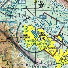
|
CAUTION: Diagram may not be current
 Download PDF
of official airport diagram from the FAA
| Airport distance calculator |
|---|
|
|
| Sunrise and sunset |
|---|
|
Times for 21-Apr-2026
| | Local
(UTC-7) | | Zulu
(UTC) |
|---|
| Morning civil twilight | | 05:43 | | 12:43 |
| Sunrise | | 06:09 | | 13:09 |
| Sunset | | 19:21 | | 02:21 |
| Evening civil twilight | | 19:47 | | 02:47 |
|
| Current date and time |
|---|
| Zulu (UTC) | 21-Apr-2026 21:17:56 |
|---|
| Local (UTC-7) | 21-Apr-2026 14:17:56 |
|---|
|
| METAR |
|---|
| KPSP | 212053Z 32011G20KT 10SM CLR 29/M03 A2988 RMK AO2 SLP114 T02941028 58022
|
|
| TAF |
|---|
| KPSP | 211728Z 2118/2218 VRB05KT P6SM SKC FM212000 32018G28KT P6SM FEW060 SCT100 FM220900 32010KT P6SM SKC
|
|
| NOTAMs |
|---|
NOTAMs are issued by the DoD/FAA and will open in a separate window not controlled by AirNav.
|
|
FBO, Fuel Providers, and Aircraft Ground Support |
|---|
| | 
Business Name | |
Contact | |
Services / Description | |
Fuel Prices | |
Comments | |
|---|
 |
|
ASRI 129.975
760-320-7704
[web site]
[email] |
|
Atlantic Aviation is your premier aviation service provider with more than 100 locations in North America, including Hawaii and the Caribbean. We provide standard ground services you'd expect, with a detailed focus on ensuring an unforgettable customer experience.


|
|
 | | 100LL | Jet A | SAF | | FS | | $9.69 | | $10.54 | | $12.50 | | Updated 21-Apr-2026 |
|
|

1 read write
|
|
 |
|
ASRI 129.725
760-327-1201
[web site]
[email] |
|
Signature Aviation at Palm Springs International Airport (PSP) provides safe, seamless private aviation access to the Coachella Valley, connecting travelers to Palm Springs' renowned golf, desert landscapes, and cultural attractions, including the Indian Wells Tennis Garden.
To request Palm Springs FBO services or manage your visit, log into your Signature Vision account at
https://www.signatureaviation.com/services/signature-vision

|
|
| | 100LL | Jet A | SAF | | FS | | $8.85 | | $9.64 | | $11.49 | | Updated 21-Apr-2026 |
|
|
1 read write
|
|
Alternatives at nearby airports
IMPORTANT: Note that the FBOs below are NOT at KPSP but at other nearby airports. Do not expect services from these FBOs to be available at KPSP. |
 |
|
ASRI 130.85
760-925-5876
toll-free 800-338-5876
[web site]
[email] |
|
At KTRM (Jacqueline Cochran Regional Airport), 21 miles SE
Desert Jet Center, an award-winning full-service FBO at KTRM, provides a cost-effective alternative to KPSP.
As a CAA Preferred FBO, we ensure top-notch service, safety, and modern amenities--all with NO SPECIAL EVENT FEES.
Located just 30 minutes from Rancho Mirage and Indian Wells and 15 minutes from La Quinta and Indio, we are the closest FBO to major events like the Empire Polo Club's music festivals and Thermal Club INDYCAR.
Enjoy competitive pricing, a hangar for aircraft up to a Global 7000, and convenient onsite services, including maintenance, detailing, and rental vehicles.
|
|
|
|

6 read write
|
|

|
| |
Aviation Businesses, Services, and Facilities |
|---|
| |
Business Name | |
Contact | |
Services / Description | |
Distance | |
Comments | |
|---|
|
|
|
760-325-7106
760-333-9020
[web site]
[email] |
|
CheckSix AeroSolutions, LLC is an FAA-Certified Part 145 Repair Station. Our in-house team of licensed A&P mechanics and avionics technicians offer maintenance, repair, and modification to the GA aircraft community in Southern California and beyond.


|
|
on airport |
|
write
|
|
|
|
|
760-394-8500
[web site]
[email] |
|
ALERT: Enjoy 50% OFF LABOR for Scheduled Maintenance at our FAA Part 145 Repair Station in Thermal until Sept. 30th. We also provide unscheduled maintenance and AOG support, ensuring precision, experience, and timeliness for your aircraft.

|
|
on airport |
|
write
|
|
| |
Things to do: Attractions on or near the airport |
|---|
| |
Business Name | |
Contact | |
Services / Description | |
Distance | |
Comments | |
|---|
| Palm Springs Air Museum |
|
760-778-6262
|
|
no information available
If you are affiliated with Palm Springs Air Museum and would like to show here your services, contact info, web link, logo, and more, click here
|
|
on airport |
|
write
|
|
| |
Would you like to see your business listed on this page? |
|---|
| | If your business provides an interesting product or service to pilots, flight crews, aircraft, or users of the Palm Springs International Airport, you should consider listing it here. To start the listing process, click on the button below

|


